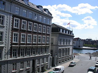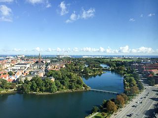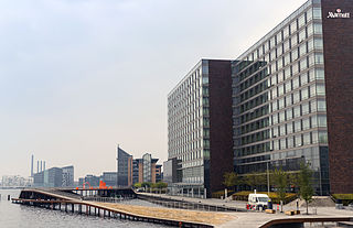
Christianshavn is a neighbourhood in Copenhagen, Denmark. Part of the Indre By District, it is located on several artificial islands between the islands of Zealand and Amager and separated from the rest of the city centre by the Inner Harbour. It was founded in the early 17th century by Christian IV as part of his extension of the fortifications of Copenhagen. Originally, it was laid out as an independent privileged merchant's town with inspiration from Dutch cities but it was soon incorporated into Copenhagen proper. Dominated by canals, it is the part of Copenhagen with the most nautical atmosphere.

Kongens Enghave, commonly known as Sydhavnen or the postal district of 2450 Copenhagen SV (southwest) is a district in southern Copenhagen. While its core is a largely pre-WWII former working class district, it also contains an upscale residential area along the harbour having been developed after 2000, scattered industrial areas, large parks such as Valbyparken and Sydhavnstippen, allotment gardens and parts of Vestre Kirkegård, the city's largest cemetery.

Islands Brygge station is a rapid transit station of the Copenhagen Metro in Copenhagen, Denmark. The first station on the M1 Line after its split from the M2 Line at Christianshavn, it is located in zone 1 in the northwestern section of the island of Amager.

Amagerbanen was a Danish railroad line from Copenhagen to Dragør on the island Amager, inaugurated on July 10, 1907.

North Atlantic House is a cultural centre located on the harbour front in Copenhagen, Denmark, dedicated to preserve, promote and communicate culture and art from the North Atlantic area. It is made as a cooperation between Denmark, Iceland, Greenland and the Faroe Islands and includes three galleries and conference facilities. The centre also houses the Icelandic embassy and the permanent representations of Greenland and the Faroe Islands, as well as some commercial activities and enterprises related to the area.

Holmen is a water-bound neighbourhood in Copenhagen, Denmark, occupying the former grounds of the Royal Naval Base and Dockyards. In spite of its name, deceptively in singular, Holmen is a congregation of small islands, forming a north-eastern extension of Christianshavn between Zealand and the northern tip of Amager.

Bryggebroen is one of the new bicycle/pedestrian bridges in Copenhagen inner harbour and is a 190 metres (620 ft) combined pedestrian and bicyclist bridge directed east-west. The bridge is joined to Kalvebod Brygge and Cykelslangen bridge (west) and Islands Brygge (east) and thus connects Vesterbro on Zealand and Amager. The bridge has become a popular place for attaching love padlocks.

Havneparken is a public park located directly on the waterfront in the district of Islands Brygge in central Copenhagen, Denmark. It is one of the most lively and popular places along the Copenhagen harbourfront. Located in a former dockland area, the park has retained a number of features from the area's industrial past, including disused railway tracks and an abandoned railway car used as an exhibition space, while am old ship hull turned upside-down serves as an idiosyncratic bandstand and pavilion. The park is also the location of the Islands Brygge Cultural Centre and the Islands Brygge Harbour Bath.

Teglholmen is a peninsula in the South Harbour of Copenhagen, Denmark, located between Sluseholmen and Enghave Brygge. The former dockland area used to house heavy industry. While some industry activities remain in the area, but since most industry left the area, starting in the 1970s, it has undergone massive redevelopment, though some industrial activities remain, most notably MAN B&W Diesel's motor development plant. Today the area houses both a considerable number of Danish and regional headquarters of multinational companies and residential developments. Teglholmen is home to Aalborg University's AAU Cph Campus as well as TV 2's activities in Copenhagen.
Districts of Copenhagen are often based on informal designations based on historic origins, often with alternative names and loosely defined boundaries. Copenhagen Municipality is divided into 10 official administrative districts but they often comprise areas of a heterogeneous character which are informally not seen as one district. Some districts have earlier been official subdivisions and thus have semi-official boundaries. Copenhagen postal code designations often correspond to district boundaries but in some cases differ from them, as an example parts of the city centre has the postal code København V which is generally associated with Vesterbro.

Gammelholm is a predominantly residential neighbourhood in the city centre of Copenhagen, Denmark. It is bounded by the Nyhavn canal, Kongens Nytorv, Holmens Kanal, Niels Juels Gade and the waterfront along Havnegade. For centuries, the area was the site of the Royal Naval Shipyard, known as Bremerholm, but after the naval activities relocated to Nyholm, it came under residential redevelopment in the 1860s and 1870s. The new neighbourhood was planned by Ferdinand Meldahl and has also been referred to as "Meldahl's Nine Streets". Apart from the buildings which face Kongens Nytorv, which include the Royal Danish Theatre and Charlottenborg Palace, the area is characterized by homogeneous Historicist architecture consisting of perimeter blocks with richly decorated house fronts.

Christianshavns Vold is a former rampart which was part of the bastioned fortification ring which used to surround Copenhagen, Denmark. Running along the full south-eastern perimeter of Christianshavn and Holmen, it used to form a protective barrier towards the island of Amager. It consists of earthworks with 12 bastions and in front of it ran a moat, Stadsgraven, now forming a broad canal which separates Christianshavn from the rest of Amager. On the other side of Stadsgraven. on Amager, was a lower system of outworks called Christianshavns Enveloppe of which only the northern half survives. Along with Kastellet on the other side of the harbour, it is the only intact part of the fortification system.

Christian IV's Arsenal, is a historic building on Slotsholmen in central Copenhagen, Denmark. It was built by Christian IV of Denmark in 1604 as part of a grand scheme for the construction of a new naval harbour. The arsenal, along with several other buildings, surrounded the harbour basin which was connected to the main harbour by a narrow canal. Later, when ships became too large to enter the harbour, the fleet moved to Bremerholm and the decommissioned naval harbour was later filled in.

Kalvebod Brygge is a waterfront area in the Vesterbro district of Copenhagen, Denmark. The name also refers to a section of the Ring 2 ring road which follows the waterfront from Langebro in the north to the H. C. Ørsted Power Station in the south. The area is dominated by office buildings, Tivoli Conference Center, several hotels and the shopping centre Fisketorvet.

Applebyes Plads is a triangular area located between Langebro Bridge and the southernmost portion of Christianshavn Canal at the southern tip of the Christianshavn neighbourhood in Copenhagen, Denmark. The area takes its name from Peter Applebye, Christian VI's rope maker, who ran his manufactury from the site in the late 18th century, although no buildings remain from that time. The Danish Sugar Factories' building along the waterfront dates from 1912 while the rest of the grounds have undergone residential redevelopment in later years.

Strandgade is one of the principal streets in the Christianshavn district of Copenhagen, Denmark. It runs along the full length of the neighbourhood, following the harbourfront, from Christian's Church in the south-west to Grønlandske Handels Plads in the north

Enghave Brygge is a waterfront area in the Southern Docklands of Copenhagen, Denmark. It is located between Teglholmen to the south and Kalvebod Brygge to the north. Currently an abandoned industrial site, a plan for its redevelopment was adopted in July 2013. The most prominent landmark in the area is the H. C. Ørsted Power Station.

Havneholmen is a mixed-use development located on reclaimed land off Kalvebod Brygge in the harbor of Copenhagen, Denmark. It is located just east of the shopping centre Fisketorvet from which it is separated by a narrow canal, although it is annexed to mainland Kalvebod Brygge at its southern end.

(Kongelige) Grønlandske Handels Plads is a waterfront area at the end of Strandgade in the northwestern corner of the Christianshavn neighbourhood of Copenhagen, Denmark. The area is bounded by the Trangraven canal to the north, Christianshavn Canal to the east, Krøyers Plads to the south and the main harbor to the west. The waterfront is also known as Nordatlantens Brygge. It is named for the Royal Greenland Trading Department and was for more than 200 years a hub for Danish trade on Greenland, Iceland and the Faroe Islands. The most notable building is North Atlantic House, an 18th-century warehouse now used as a cultural centre for the North Atlantic area.

Amager Boulevard is a street on Amager in Copenhagen, Denmark. It begins at Langebro Bridge and initially follows Stadsgraven east to a Y-junction from where it continues inland to Amagerbrogade while the street Ved Stadsgraven continues along the water to the Christmas Møllers Plads.


