
The Nez Perce are an Indigenous people of the Plateau who still live on a fraction of the lands on the southeastern Columbia River Plateau in the Pacific Northwest. This region has been occupied for at least 11,500 years.
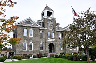
Wallowa County is the northeastern most county in the U.S. state of Oregon. As of the 2020 census, the population was 7,391, making it Oregon's fifth-least populous county. Its county seat is Enterprise. According to Oregon Geographic Names, the origins of the county's name are uncertain, with the most likely explanation being it is derived from the Nez Perce term for a structure of stakes used in fishing. An alternative explanation is that Wallowa is derived from a Nez Perce word for "winding water". The journals of Lewis and Clark Expedition record the name of the Wallowa River as Wil-le-wah.

Wallowa is a city in Wallowa County, Oregon, United States. The population was 808 at the 2010 census.

Hin-mah-too-yah-lat-kekt, popularly known as Chief Joseph, Young Joseph, or Joseph the Younger, was a leader of the wal-lam-wat-kain (Wallowa) band of Nez Perce, a Native American tribe of the interior Pacific Northwest region of the United States, in the latter half of the 19th century. He succeeded his father tuekakas in the early 1870s.

The Wallowa Mountains are a mountain range located in the Columbia Plateau of northeastern Oregon in the United States. The range runs approximately 40 miles (64 km) northwest to southeast in southwestern Wallowa County and eastern Union County between the Blue Mountains to the west and the Snake River to the east. The range is sometimes considered to be an eastern spur of the Blue Mountains, and it is known as the "Alps of Oregon". Much of the range is designated as the Eagle Cap Wilderness, part of the Wallowa–Whitman National Forest.

The Nez Perce War was an armed conflict in 1877 in the Western United States that pitted several bands of the Nez Perce tribe of Native Americans and their allies, a small band of the Palouse tribe led by Red Echo (Hahtalekin) and Bald Head, against the United States Army. Fought between June and October, the conflict stemmed from the refusal of several bands of the Nez Perce, dubbed "non-treaty Indians," to give up their ancestral lands in the Pacific Northwest and move to an Indian reservation in Idaho Territory. This forced removal was in violation of the 1855 Treaty of Walla Walla, which granted the tribe 7.5 million acres of their ancestral lands and the right to hunt and fish on lands ceded to the U.S. government.

The Wallowa River is a tributary of the Grande Ronde River, approximately 55 miles (89 km) long, in northeastern Oregon in the United States. It drains a valley on the Columbia Plateau in the northeast corner of the state north of Wallowa Mountains.

The Nez Perce National Historical Park is a United States National Historical Park comprising 38 sites located across the states of Idaho, Montana, Oregon, and Washington, which include traditional aboriginal lands of the Nez Perce people. The sites are strongly associated with the resistance of Chief Joseph and his band, who in June 1877 migrated from Oregon in an attempt to reach freedom in Canada and avoid being forced on to a reservation. They were pursued by U.S. Army cavalry forces and fought numerous skirmishes against them during the so-called Nez Perce War, which eventually ended with Chief Joseph's surrender in the Montana Territory.

Big Hole National Battlefield preserves a battlefield in the western United States, located in Beaverhead County, Montana. In 1877, the Nez Perce fought a delaying action against the U.S. Army's 7th Infantry Regiment here on August 9 and 10, during their failed attempt to escape to Canada. This action, the Battle of the Big Hole, was the largest battle fought between the Nez Perce and U.S. Government forces in the five-month conflict known as the Nez Perce War.

The Nez Perce (Nee-Me-Poo) National Historic Trail follows the route taken by a large group of the Nez Perce tribe in 1877 to avoid being forced onto a reservation. The 1,170-mile (1,883 km) trail was created in 1986 as part of the National Trails System Act and is managed by the U.S. Forest Service. The trail traverses through portions of the U.S. states of Oregon, Idaho, Wyoming, and Montana and connects sites across these states that commemorate significant events of the Nez Perce War that took place between June and October 1877, as several bands of the Nez Perce tried to escape capture by the U.S. Cavalry. The sites are among the 38 that are part of the National Park service's Nez Perce National Historical Park, managed over all by the National Park Service, with some sites managed by local and state affiliated organizations.

The Lostine River is a 31.4-mile-long (50.5 km) tributary of the Wallowa River in northeastern Oregon in the United States. It drains a portion of the Eagle Cap Wilderness of the Wallowa Mountains in the Wallowa–Whitman National Forest and joins the Wallowa River at Wallowa.
The Wallowa–Whitman National Forest is a United States National Forest in the U.S. states of Oregon and Idaho. Formed upon the merger of the Wallowa and Whitman national forests in 1954, it is located in the northeastern corner of the state, in Wallowa, Baker, Union, Grant, and Umatilla counties in Oregon, and includes small areas in Nez Perce and Idaho counties in Idaho. The forest is named for the Wallowa band of the Nez Perce people, who originally lived in the area, and Marcus and Narcissa Whitman, Presbyterian missionaries who settled just to the north in 1836. Forest headquarters are located in Baker City, Oregon with ranger districts in La Grande, Joseph and Baker City.
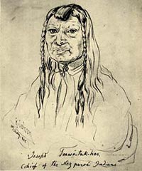
tuekakas, commonly known as Old Chief Joseph or Joseph the Elder, was a Native American leader of the Wallowa Band of the Nez Perce. Old Joseph was one of the first Nez Percé converts to Christianity and a vigorous advocate of the tribe's early peace with whites. In 1855 he aided Washington's territorial governor and set up a Nez Percé reservation that expanded from Oregon into Idaho. The Nez Perce agreed to give up a section of their tribal lands in return for an assurance whites would not intrude upon the sacred Wallowa Valley.

Wallowa Lake is a ribbon lake 1 mile (1.6 km) south of Joseph, Oregon, United States, at an elevation of 4,372 ft (1,333 m). Impounded by high moraines, it was formed by a series of Pleistocene glaciers. On the south end of the lake is a small community made up of vacation homes, lodging, restaurants, as well as other small businesses. Wallowa Lake has been used for recreation since at least 1880. The Wallowa Lake State Park is at the southern tip of the lake.

The Old Chief Joseph Gravesite, also known as Nez Perce Traditional Site, Wallowa Lake, Chief Joseph Cemetery and Joseph National Indian Cemetery is a Native American cemetery near Joseph, Oregon. The area was also a traditional campsite of the Nez Perce and may be archaeologically significant. It was declared a National Historic Landmark in 1985, listed as Wallowa Lake Site. It is a component of the Nez Perce National Historical Park.
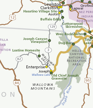
Joseph Canyon is a 2,000-foot (610 m)-deep basalt canyon in northern Wallowa County, Oregon, and southern Asotin County, Washington, United States.

Chief Joseph Mountain is a 9,616-foot elevation (2,931 m) mountain summit located in Wallowa County, Oregon, US.


