Jacksonville, Vermont

Last updated

Jacksonville, Vermont
Jacksonville, Vermont.jpg
Street in Jacksonville, Vermont
USA Vermont location map.svg
Red pog.svg
Jacksonville, Vermont
Location within the state of Vermont
Coordinates: 42°47′50″N72°49′13″W / 42.79722°N 72.82028°W / 42.79722; -72.82028
Country United States
State Vermont
County Windham
Area
[1]
  Total1.16 sq mi (3.01 km2)
  Land1.14 sq mi (2.95 km2)
  Water0.03 sq mi (0.07 km2)
Elevation
1,358 ft (414 m)
Population
 (2020)
  Total213
  Density180/sq mi (71/km2)
Time zone UTC-5 (Eastern (EST))
  Summer (DST) UTC-4 (EDT)
ZIP code
05342
Area code 802
FIPS code 50-36025 [2]
GNIS feature ID1457983 [3]

Jacksonville is a village in the town of Whitingham, Windham County, Vermont, United States. The population was 213 at the 2020 census. [4]

Contents

Geography

According to the United States Census Bureau, the village has a total area of 1.2 square miles (3.0 km2), of which 1.1 square miles (3.0 km2) is land and 0.04 square mile (0.1 km2) (1.71%) is water.

Demographics

Historical population
CensusPop.Note
1910 212
1920 2214.2%
1930 220−0.5%
1940 2409.1%
1950 220−8.3%
1960 2409.1%
1970 2514.6%
1980 2520.4%
1990 244−3.2%
2000 237−2.9%
2010 223−5.9%
2020 213−4.5%
U.S. Decennial Census [5]

As of the census [2] of 2000, there were 237 people, 88 households, and 60 families residing in the village. The population density was 207.5 people per square mile (80.3/km2). There were 108 housing units at an average density of 94.6/sq mi (36.6/km2). The racial makeup of the village was 98.73% White, 0.84% Native American, and 0.42% from two or more races. Hispanic or Latino of any race were 1.27% of the population.

There were 88 households, out of which 43.2% had children under the age of 18 living with them, 54.5% were married couples living together, 10.2% had a female householder with no husband present, and 31.8% were non-families. 23.9% of all households were made up of individuals, and 10.2% had someone living alone who was 65 years of age or older. The average household size was 2.69 and the average family size was 3.28.

In the village, the population was spread out, with 29.1% under the age of 18, 11.4% from 18 to 24, 30.4% from 25 to 44, 18.6% from 45 to 64, and 10.5% who were 65 years of age or older. The median age was 33 years. For every 100 females, there were 76.9 males. For every 100 females age 18 and over, there were 76.8 males.

The median income for a household in the village was $33,438, and the median income for a family was $34,821. Males had a median income of $26,500 versus $21,786 for females. The per capita income for the village was $17,485. About 9.8% of families and 9.2% of the population were below the poverty line, including 16.2% of those under the age of eighteen and 18.5% of those 65 or over.

Notable person

Matt Johnson from the music duo Matt & Kim grew up in Jacksonville.

Climate

This climatic region is typified by large seasonal temperature differences, with warm to hot (and often humid) summers and cold (sometimes severely cold) winters. According to the Köppen Climate Classification system, Jacksonville has a humid continental climate, abbreviated "Dfb" on climate maps. [6]

Related Research Articles

<span class="mw-page-title-main">Jacksonville, Arkansas</span> City in Arkansas, United States

Jacksonville is a city in Pulaski County, Arkansas, United States, and a suburb of Little Rock. As of the 2010 census, the population of the city was 28,364. It is part of the Little Rock–North Little Rock–Conway Metropolitan Statistical Area with 729,135 people as of 2014.

<span class="mw-page-title-main">Cottondale, Florida</span> City in Florida, United States

Cottondale is a city in Jackson County, Florida, United States. It is part of the Florida Panhandle and North Florida. The population was 848 at the 2020 census, down from 933 at the 2010 census.

<span class="mw-page-title-main">Fraser, Michigan</span> City in Michigan, United States

Fraser is a city in Macomb County in the U.S. state of Michigan. A northern suburb of Detroit, Fraser is located roughly 15 miles (24.1 km) northeast of downtown Detroit. As of the 2020 census, the city had a population of 14,726.

<span class="mw-page-title-main">Millersburg, Michigan</span> Village in Michigan, United States

Millersburg is a village in Presque Isle County of the U.S. state of Michigan. The population was 206 at the 2010 census. The village is within Case Township.

<span class="mw-page-title-main">Waltham, Minnesota</span> City in Minnesota, United States

Waltham is a city in Mower County, Minnesota, United States. The population was 164 at the 2020 census.

<span class="mw-page-title-main">Jacksonville, Ohio</span> Village in Ohio, United States

Jacksonville is a village in Athens County, Ohio, United States. The population was 400 at the 2020 census.

Arroyo Alto is a neighborhood of the city of La Feria in Cameron County, in the U.S. state of Texas. Annexed by the city in 2004, Arroyo Alto was a census-designated place (CDP) at the 2000 census, at which time it had a population of 320. It is part of the Brownsville–Harlingen Metropolitan Statistical Area.

<span class="mw-page-title-main">Lakeside, Tarrant County, Texas</span> Place in Texas, United States

Lakeside is a town in Tarrant County, Texas, United States. The population was 1,649 at the 2020 census.

<span class="mw-page-title-main">Manchester Center, Vermont</span> Census-designated place in Vermont, United States

Manchester Center is a census-designated place (CDP) in the town of Manchester in Bennington County, Vermont, United States. As of the 2010 census, the CDP had a population of 2,120, out of 4,391 people in the entire town of Manchester.

<span class="mw-page-title-main">Enosburgh, Vermont</span> Town in Vermont, United States

Enosburgh is a town in Franklin County, Vermont, in the United States. The population was 2,810 at the 2020 census. Enosburgh includes the village of Enosburg Falls and the settlements of Bordoville, East Enosburgh, North Enosburgh, Sampsonville, West Enosburgh, and Enosburgh Center. Enosburgh was named for Roger Enos, who had been a commander of all the Vermont Forces in the American Revolution. He was also the father-in-law of Ira Allen, founder of Vermont. The spelling of Enosburgh differs from the spelling of Enosburg Falls.

<span class="mw-page-title-main">Enosburg Falls, Vermont</span> Village in Vermont, United States

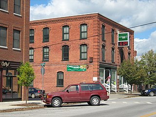
Enosburg Falls is a village in the town of Enosburgh in Franklin County, Vermont, in the United States. The population was 1,356 at the 2020 census.

<span class="mw-page-title-main">Morristown, Vermont</span> Town in Vermont, United States

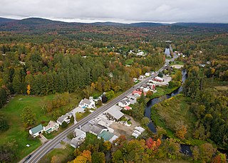
Morristown is a town in Lamoille County, Vermont, United States. As of the 2020 census, the population was 5,434. Morristown is the largest town by population in Lamoille County, and its central village of Morrisville serves as the county's main commercial center.

<span class="mw-page-title-main">Derby Center, Vermont</span> Village in Vermont, United States

Derby Center is a village in the town of Derby, Orleans County, Vermont, United States. The population was 635 at the 2020 census.

<span class="mw-page-title-main">Chittenden, Vermont</span> Town in Vermont, United States

Chittenden is a town in Rutland County, Vermont, United States. The population was 1,237 at the 2020 census.

<span class="mw-page-title-main">Dover, Vermont</span> Town in Vermont, United States

Dover is a town in Windham County, Vermont, United States. The population was 1,798 at the 2020 census. It is famed for being the location of the Mount Snow ski area.

<span class="mw-page-title-main">Londonderry, Vermont</span> Town in Vermont, United States

Londonderry is a town in Windham County, Vermont, United States. It is bounded on the north by Landgrove and Weston, on the east by Windham, on the south by Jamaica and on the west by Winhall and Landgrove. The population was 1,919 in the 2020 census. The town contains the villages of Londonderry and South Londonderry.

North Westminster is a census-designated place (CDP) in Windham County, Vermont, United States. The population was 262 at the 2020 census. Formerly an incorporated village, it surrendered its charter on April 20, 2010 and reverted to the town of Westminster. The village area and additional surroundings were defined by the U.S. Census Bureau as a CDP in 2012.

<span class="mw-page-title-main">Onley, Virginia</span> Town in Virginia, United States

Onley is a town in Accomack County, Virginia, United States. The population was 516 at the 2010 census.

<span class="mw-page-title-main">Potter Lake, Wisconsin</span> CDP in Wisconsin, United States

Potter Lake is a census-designated place (CDP) in the town of East Troy, Walworth County, Wisconsin, United States. The population was 1,117 at the 2020 census.

<span class="mw-page-title-main">Johnson, Vermont</span> Town in Vermont, United States

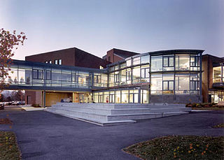
Johnson is a town in Lamoille County, Vermont, United States. The population was 3,491 at the 2020 census. The town is home to Northern Vermont University-Johnson, a part the Vermont State Colleges system. The Vermont Studio Center is located in the village of Johnson. Since 1842, the town has been the home to Johnson Woolen Mills.

References

  1. "2019 U.S. Gazetteer Files". United States Census Bureau. Retrieved August 7, 2020.
  2. 1 2 "U.S. Census website". United States Census Bureau . Retrieved January 31, 2008.
  3. "US Board on Geographic Names". United States Geological Survey. October 25, 2007. Retrieved January 31, 2008.
  4. "Census - Geography Profile: Jacksonville village, Vermont". United States Census Bureau . Retrieved December 26, 2021.
  5. "Census of Population and Housing". Census.gov. Retrieved June 4, 2015.
  6. Climate Summary for Jacksonville, Vermont

42°47′49″N72°49′18″W / 42.79694°N 72.82167°W / 42.79694; -72.82167