Jamesville, North Carolina

Last updated

Jamesville, North Carolina
Center of Jamesville, North Carolina.png
NCMap-doton-Jamesville.PNG
Location of Jamesville, North Carolina
Coordinates: 35°48′44″N76°54′01″W / 35.81222°N 76.90028°W / 35.81222; -76.90028
Country United States
State North Carolina
County Martin
Area
[1]
  Total1.46 sq mi (3.77 km2)
  Land1.46 sq mi (3.77 km2)
  Water0.00 sq mi (0.00 km2)
Elevation
[2]
36 ft (11 m)
Population
 (2020)
  Total424
  Density291.21/sq mi (112.41/km2)
Time zone UTC-5 (Eastern (EST))
  Summer (DST) UTC-4 (EDT)
ZIP code
27846
Area code 252
FIPS code 37-34320 [3]
GNIS feature ID2405905 [2]

Jamesville is a town in Martin County, North Carolina, United States. The population was 491 at the 2010 census.

Contents

Geography

According to the United States Census Bureau, the town has a total area of 1.3 square miles (3.4 km2), all land.

Demographics

Historical population
CensusPop.Note
1860 46
1870 150226.1%
1880 29999.3%
1890 34615.7%
1900 235−32.1%
1910 39869.4%
1920 389−2.3%
1930 344−11.6%
1940 49945.1%
1950 5296.0%
1960 5381.7%
1970 533−0.9%
1980 60413.3%
1990 6121.3%
2000 502−18.0%
2010 491−2.2%
2020 424−13.6%
U.S. Decennial Census [4]

As of the census [3] of 2000, there were 502 people, 199 households, and 140 families residing in the town. The population density was 375.1 people per square mile (144.8 people/km2). There were 233 housing units at an average density of 174.1 per square mile (67.2/km2). The racial makeup of the town was 64.94% of White, 33.86% African American, 1.00% from other races, and 0.20% from two or more races. Hispanic or Latino of any race were 1.20% of the population.

There were 199 households, out of which 32.2% had children under the age of 18 living with them, 46.2% were married couples living together, 18.6% had a female householder with no husband present, and 29.6% were non-families. 27.6% of all households were made up of individuals, and 16.1% had someone living alone who was 65 years of age or older. The average household Aaron size was 2.52 and the average family size was 3.04.

In the town, the population was spread out, with 28.1% under the age of 18, 6.2% from 18 to 24, 25.1% from 25 to 44, 22.1% from 45 to 64, and 18.5% who were 65 years of age or older. The median age was 38 years. For every 100 females, there were 92.3 males. For every 100 females age 18 and over, there were 81.4 males.

The median income for a household in the town was $28,438, and the median income for a family was $32,813. Males had a median income of $32,045 versus $20,208 for females. The per capita income for the town was $16,682. About 21.5% of families and 19.7% of the population were below the poverty line, including 31.7% of those under age 18 and 13.4% of those age 65 or over.

Education

In literature and fiction

The town of Jamesville is featured in Don Brown's historical fiction novel Destiny , the prequel to Brown's Navy Justice Series. [5]

Notable person

Jimmy Brown - Major League Baseball infielder with the St. Louis Cardinals

Related Research Articles

<span class="mw-page-title-main">Elmore, Alabama</span> Town in Alabama, United States

Elmore is a town in Elmore County, Alabama, United States. Although initially incorporated in 1906, it lapsed and was not reincorporated again until 1997. At the 2010 census the population was 1,262, up from 199 in 2000. It is part of the Montgomery Metropolitan Statistical Area.

<span class="mw-page-title-main">Staunton, Indiana</span> Town in Indiana, United States

Staunton is a town in Posey Township, Clay County, Indiana, United States. The population was 534 at the 2010 census. It is part of the Terre Haute Metropolitan Statistical Area.

<span class="mw-page-title-main">Coatesville, Indiana</span> Town in Indiana, United States

Coatesville is a town in Clay Township, Hendricks County, Indiana, United States. The population was 523 at the 2010 Census.

<span class="mw-page-title-main">Holton, Indiana</span> Town in Indiana, United States

Holton is a town in Otter Creek Township, Ripley County, in the U.S. state of Indiana. The population was 480 at the 2010 census.

<span class="mw-page-title-main">Dyer Brook, Maine</span> Town in the state of Maine, United States

Dyer Brook is a town in Aroostook County, Maine, United States. The population was 215 at the 2020 census. Dyer Brook is also host to the local school, Southern Aroostook Community School.

<span class="mw-page-title-main">Upton, Maine</span> Town in the state of Maine, United States

Upton is a town in Oxford County, Maine, United States. The population was 69 at the 2020 census.

<span class="mw-page-title-main">Mercer, Maine</span> Town in Maine, United States

Mercer is a town in Somerset County, Maine, United States. The town was named after the Revolutionary War hero Hugh Mercer. The population was 709 at the 2020 census.

Marshfield is a town in Washington County, Maine, United States. The population was 528 at the 2020 census.

<span class="mw-page-title-main">LaFayette, New York</span> Town in Onondaga County, New York, U.S.

LaFayette is a town in Onondaga County, New York, United States. As of the 2020 Census, its population was 4,910. The town is named after the Marquis de Lafayette, a key figure in the French and American revolutions, and widely considered a national hero of France and the United States. LaFayette is in the southern part of Onondaga County, south of Syracuse.

<span class="mw-page-title-main">Minnewaukan, North Dakota</span> City in North Dakota, United States

Minnewaukan is a city in Benson County, North Dakota, United States. It serves as the county seat and is fourth largest city in the county, after Fort Totten, Leeds, and Maddock. The population was 199 at the 2020 census. Minnewaukan was founded in 1884.

<span class="mw-page-title-main">Clarksville, Ohio</span> Village in Ohio, United States

Clarksville is a village in Clinton County, Ohio, United States. The population was 534 at the 2020 census. It is served by the Clinton Massie branch of the Wilmington Public Library of Clinton County.

<span class="mw-page-title-main">Sylvania, Pennsylvania</span> Borough in Pennsylvania, United States

Sylvania is a borough in Bradford County, Pennsylvania, United States. It is part of Northeastern Pennsylvania. The population was 216 at the 2020 census. Children residing in the borough are assigned to attend the Troy Area School District.

<span class="mw-page-title-main">Westport, South Dakota</span> Town in South Dakota, United States

Westport is a town in western Brown County, South Dakota, United States. The population was 88 at the 2020 census.

<span class="mw-page-title-main">Pax, West Virginia</span> Town in West Virginia, United States

Pax is a town in Fayette County, West Virginia, United States. The current mayor of Pax is William F. Hughes. The population was 167 at the 2010 census.

<span class="mw-page-title-main">Fairview, West Virginia</span> Town in West Virginia, United States

Fairview is a town in Marion County, West Virginia, United States. The population was 374 at the 2020 census.

<span class="mw-page-title-main">Roosevelt, Burnett County, Wisconsin</span> Town in Wisconsin, United States

Roosevelt is a town in Burnett County in the U.S. state of Wisconsin. The population was 199 at the 2010 census. The unincorporated community of Timberland is located in the town.

<span class="mw-page-title-main">Hiles, Forest County, Wisconsin</span> Town in Wisconsin, United States

Hiles is a town in Forest County, Wisconsin, United States. The population was 311 at the 2010 census. The unincorporated communities of Atkins and Hiles are located in the town.

<span class="mw-page-title-main">Forest, Vernon County, Wisconsin</span> Town in Wisconsin, United States

Forest is a town in Vernon County, Wisconsin, United States. The population was 583 at the 2000 census. The unincorporated communities of Dilly, Mount Tabor, and Valley are located in the town.

<span class="mw-page-title-main">Prairie Farm, Wisconsin</span> Village in Wisconsin, United States

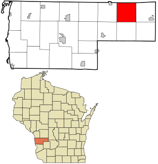
Prairie Farm is a village in Barron County in the U.S. state of Wisconsin. The population was 473 at the 2010 census. The village is located within the Town of Prairie Farm, on eastern shore of the Prairie Farm Flowage, a reservoir on the Hay River.

<span class="mw-page-title-main">Boscobel (town), Wisconsin</span> Town in Wisconsin, United States

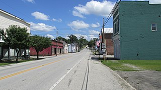
Boscobel is a town in Grant County, Wisconsin, United States. The population was 433 at the 2000 census. The town borders the city of Boscobel.

References

  1. "ArcGIS REST Services Directory". United States Census Bureau. Retrieved September 20, 2022.
  2. 1 2 U.S. Geological Survey Geographic Names Information System: Jamesville, North Carolina
  3. 1 2 "U.S. Census website". United States Census Bureau . Retrieved January 31, 2008.
  4. "Census of Population and Housing". Census.gov. Retrieved June 4, 2015.
  5. Destiny by Don Brown, Google Books