
The 2002 Pacific typhoon season was a slightly above average Pacific typhoon season, producing twenty-six named storms, fifteen becoming typhoons, and eight super typhoons. It had an ACE over 400 units, making it one of the most active seasons worldwide. It was an event in the annual cycle of tropical cyclone formation, in which tropical cyclones form in the western Pacific Ocean. The season ran throughout 2002, though most tropical cyclones typically develop between May and October. The season's first named storm, Tapah, developed on January 11, while the season's last named storm, Pongsona, dissipated on December 11. The season's first typhoon, Mitag, reached typhoon status on March 1, and became the first super typhoon of the year four days later.

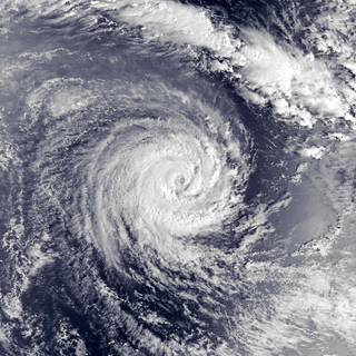
Severe Tropical Cyclone Percy was an extremely powerful tropical cyclone which was the third and last Category 5 cyclone to form in the 2004–05 South Pacific cyclone season. The seventh named storm and the fourth and final severe tropical cyclone to form during the 2004–05 South Pacific cyclone season. Percy originated as a tropical disturbance on February 23. Over the course of the next few days, the system organized while moving east-southeastward, before intensifying into a Category 1 tropical cyclone on the Australian region scale on February 26. The system quickly intensified, reaching Category 4 status later that day. On the next day, Percy was steered southward by a blocking ridge of high pressure, while stretched out the structure of the storm into an elliptical shape, weakening it back to Category 3 status. Afterward, the storm rapidly reintensified, reaching its peak intensity as a Category 5 tropical cyclone on March 2. Afterward, Percy encountered increasing wind shear and weakened once again, turning southeastward on the next day. On March 5, Percy transitioned into an extratropical storm, before dissipating soon afterward.

The 2004–05 South Pacific cyclone season was an above-average season in which tropical cyclones formed within the South Pacific Ocean to the east of 160°E. The season officially ran from November 1, 2004 to April 30, 2005, however a tropical cyclone could form at any time between July 1, 2004 and June 30, 2005 and would count towards the season total. The season got off to an early start, when Tropical Depression 01F developed near the Solomon Islands on October 28, three days before the official start of the season. The final disturbance of the season dissipated as the season was drawing to a close on May 1. The season was above-average in terms of activity, with 9 tropical cyclones and 5 severe tropical cyclones forming during the season. The season featured Cyclone Percy, the most intense of the season in terms of pressure.

The 2002–03 South Pacific cyclone season was the most active and longest tropical cyclone season since 1997–98, with ten tropical cyclones occurring within the South Pacific basin between 160°E and 120°W. The season started earlier than normal, with two systems developing before the official start of the season on November 1, 2002, while the final system dissipated on June 9, 2003, after the season had officially ended on April 30. During the season, tropical cyclones were officially monitored by the Regional Specialized Meteorological Centre (RSMC) in Nadi, Fiji and the Tropical Cyclone Warning Centres in Brisbane, Australia and Wellington, New Zealand. The United States Armed Forces through the Joint Typhoon Warning Center (JTWC), also monitored the basin and issued unofficial warnings for American interests. RSMC Nadi attaches a number and an F suffix to tropical disturbances that occur within the basin, while the JTWC designates significant tropical cyclones with a number and a P suffix. RSMC Nadi, TCWC Wellington and TCWC Brisbane all use the Australian Tropical Cyclone Intensity Scale and estimate windspeeds over a ten-minute period, while the JTWC estimates sustained winds over a one-minute period, which are subsequently compared to the Saffir–Simpson Hurricane Scale (SSHS).

Severe Tropical Cyclone Daman was the strongest cyclone of the 2007–08 South Pacific cyclone season. Cyclone Daman was the fourth tropical depression and the first severe tropical cyclone to form east of longitude 180° during the 2007–08 South Pacific cyclone season. Due to the severity of the storm, the name Daman was retired and replaced with Denia.

The 2001–02 South Pacific cyclone season was a below-average year in which only five named storms formed or entered the South Pacific basin. It began on November 1, 2001, and ended on April 30, 2002. These dates conventionally delimit the period of each year when most tropical cyclones form in the southern Pacific Ocean east of 160°E. Additionally, the regional tropical cyclone operational plan defines a tropical cyclone year separately from a tropical cyclone season, and the "tropical cyclone year" runs from July 1, 2001, to June 30, 2002. The season's sixteen tropical depressions existed within these dates with the first developing on November 29 and the last dissipating on April 22.

Intense Tropical Cyclone Ivan was a powerful tropical cyclone that struck Madagascar in February 2008. Forming from a persistent area of convection on 7 February, Ivan initially tracked southeastward, before looping to the west-southwest. Encountering favourable conditions, it strengthened to attain peak winds on 17 February before striking northeastern Madagascar. It degenerated into a remnant low pressure area as it crossed the island, and briefly re-organized into a weak tropical depression before dissipating on 22 February.

The 2008–09 South Pacific cyclone season was a below average tropical cyclone season, which featured six named tropical cyclones compared to an average of about nine. Ahead of the season officially starting on November 1, 2008, the Island Climate Update tropical cyclone outlook predicted that the season, would feature an average risk of tropical cyclones impacting the South Pacific between 160°E and 120°W. The first tropical disturbance of the season developed to the northeast of the Samoan Islands on December 1, however, it remained weak and was last noted during the next day.

The 1998–99 South Pacific cyclone season was a near average South Pacific tropical cyclone season, with 8 tropical cyclones occurring within the South Pacific Ocean basin between 160°E and 120°W. Despite the season starting on November 1, the first tropical system of the season did not form until December 1, while the final disturbance of the season dissipated on May 27, 1999. During the season the most intense tropical cyclone was Severe Tropical Cyclone Cora, which had a minimum pressure of 930 hPa (27.46 inHg). After the season had ended the names Cora and Dani were retired from the naming lists, after they had caused significant impacts to South Pacific islands.
The 2008–09 South Pacific cyclone season was a below-average season with only six tropical cyclones occurring within the South Pacific between 160°E and 120°W. The season officially ran from November 1, 2008 to April 30, 2009 with the first disturbance of the season forming on December 1 and the last disturbance moving out of the region on April 11.

Tropical Cyclone Tam was the first named storm of the 2005–06 South Pacific cyclone season. Forming out of a tropical depression on January 6, the storm gradually intensified, becoming a tropical cyclone on January 12 and receiving the name Tam. Although it was traveling at a quick pace, the storm gained organization and reached its peak intensity with winds of 85 km/h (53 mph) the following day. However, the increasing forward motion of the storm, combined with strengthening wind shear, caused Tam to rapidly weaken on January 14. Around that time, it entered the Tropical Cyclone Warning Centre in Wellington, New Zealand's area of responsibility. Shortly thereafter, the storm transitioned into an extratropical cyclone and dissipated early the next day. Cyclone Tam produced heavy rainfall and strong winds over American Samoa upon being named. The precipitation caused several mudslides and flooding, which inflicted $26,000 in damage. The storm also had minor effects on Niue, Tonga, and Futuna.

The 1988–89 South Pacific cyclone season was an active tropical cyclone season with an above average number of tropical cyclones observed.

Tropical Depression 10F was a small tropical depression that became the deadliest tropical cyclone of the 2004 season, claiming 11 lives in the Fiji islands.

Severe Tropical Cyclone Ami was one of the worst cyclones to affect Fiji. The system was the third cyclone and the second severe tropical cyclone of the 2002–03 South Pacific cyclone season. Cyclone Ami developed from a low-pressure area east of Tuvalu on January 12. Originally, the storm moved slowly towards the southwest early in its existence. Influenced by an upper-level trough, Ami slowed and began moving towards the south and then southeast. The cyclone attained severe tropical cyclone intensity on January 13. Ami made its first landfall at Vanua Levu, before subsequently making another landfall on Taveuni. Still intensifying, Ami reached peak intensity as an equivalent Category 3 cyclone on the Australian and Fiji cyclone scales on January 14. Accelerating to the southeast, the cyclone began to cross over cool sea surface temperatures and encountered wind shear. Ami transitioned into an extratropical cyclone the day after.

Severe Tropical Cyclone Pat was a small but strong tropical cyclone that passed directly over Aitutaki, Cook Islands, in southern Pacific Ocean on February 10, 2010. Part of a series of storms to impact the group of islands early that year, Pat was first identified as a tropical depression on February 6 well to the northeast of the Samoan Islands. The storm steadily organized as it moved generally southeast, becoming a tropical cyclone on February 8. Turning to the south, intensification began in earnest and the system acquired hurricane-force winds within 48 hours of being named. The 445 km (275 mi) wide system displayed annular characteristics and a 19 km (12 mi) wide eye. Pat reached its peak strength early on February 10 as a severe tropical cyclone with winds of 140 km/h (85 mph) and a barometric pressure of 960 mbar. Hours later it struck Aitutaki, producing gusts in excess of 185 km/h (115 mph) on the island. Hostile wind shear then prompted rapid weakening of the cyclone. The system degraded below gale-intensity on February 11, just 24 hours after it peaked, and was last noted early on February 12.

Severe Tropical Cyclone Namu was considered to be one of the worst tropical cyclones to impact the Solomon Islands on record, after it caused over 100 deaths within the island nations. It was first noted as a weak tropical depression to the north of the Solomon Islands during May 15, 1986. Over the next couple of days, the storm steadily intensified while meandering. After briefly moving west, the storm attained Category 2 intensity on the Australian intensity scale on May 18, as it moved through the island chain on the next day. Cyclone Namu attained peak intensity of 150 km/h (90 mph). After retaining its peak intensity for a day, Namu turned south and weakened steadily. By May 21, the winds of Cyclone Namu had been reduced to only 80 km/h (50 mph). Continuing to weaken, Namu turned east and dissipated on May 22, away from the island chain.

Severe Tropical Cyclone Eric was one of two tropical cyclones to affect the island nations of Vanuatu and Fiji within a week during January 1985. The precursor shallow depression developed within the monsoon trough during 13 January, to the west of Espiritu Santo, Vanuatu. On 16 January, the storm developed-hurricane-force winds and Eric began to undergo rapid deepening. While two different agencies differ on when and how strong Eric was at its peak, it was believed to have peaked on 17 January while passing through the Fiji island group. Shortly after its peak, Eric began to weaken steadily, and by 20 January, Severe Tropical Cyclone Eric had ceased to exist as a tropical cyclone. Combined with another storm – Cyclone Nigel – Eric caused 25 fatalities and $40 million worth of damage. A total of 299 farms were affected as well as the airport in Nadi. About 30,000 people were left homeless. Severe crop damage was also reported. Viti Levu sustained the worst effects from Cyclone Eric. During the aftermath of the storm, a number of first world countries distributed aid for victims of Eric.
Severe Tropical Cyclone Raja was a tropical cyclone that holds the 24-hour rainfall record of 674.9 mm (26.57 in) for the French Overseas Territory of Wallis and Futuna. The system was first noted by the Fiji Meteorological Service (FMS) as a weak tropical disturbance northeast of Tokelau in mid-December 1986. The system developed further as it moved southwest over the next few days, and it was classified as Tropical Cyclone Raja on 23 December. The newly named system slowed and unexpectedly recurved southeast towards the French territory of Wallis and Futuna on 24 December. Over the next two days, Raja interacted with what would become Severe Cyclone Sally and executed a tight loop, passing within 55 km (35 mi) of Futuna. The system peaked as a Category 3 severe tropical cyclone on 28 December, with estimated 10-minute sustained winds of 90 mph (150 km/h). The storm turned southwest the next day and threatened Fiji, where it passed within 20 km (10 mi) of Vanua Levu and near several smaller islands in the Lau group during the following day. Raja gradually weakened over the next few days as it moved south of Fiji; it was last noted on 5 January 1987 after it filled up over the north Tasman Sea.

Severe Tropical Cyclone Gita was the most intense tropical cyclone to impact Tonga since reliable records began. The second named storm and first major tropical cyclone of the 2017–18 South Pacific cyclone season, Gita originated from a monsoon trough that was active in the South Pacific in early February 2018. First classified as a tropical disturbance on 3 February, the nascent system meandered near Vanuatu for several days with little development. After acquiring a steady east trajectory near Fiji, it organized into a Category 1 tropical cyclone on 9 February near Samoa. Arcing south in a clockwise turn, the system rapidly intensified, and became a severe tropical cyclone on 10 February near Niue.

Severe Tropical Cyclone Tino was a tropical cyclone which itself and an associated convergence zone caused significant damage across ten island nations in the South Pacific Ocean during January 2020. First noted as a tropical disturbance during January 11, to the southwest of Honiara in the Solomon Islands, the system gradually developed over the next few days as it moved eastwards in between the Solomon Islands and Vanuatu prior to being named Tino as it approached Fiji during January 16. Continuing to track south-eastward, Tino continued strengthening as it passed near Fiji, bringing copious amounts of rainfall to the area. Whilst losing latitude, the system continued to strengthen and peaked as a category 3 tropical cyclone on January 17, with signs of an eye forming. Shortly after peak intensity, Tino was impacted by high wind shear and decreasing sea surface temperatures, triggering a weakening trend. Tino moved out of the tropics shortly thereafter and became an extratropical cyclone during January 19.

