Jefferson County, Mississippi

Last updated

Jefferson County
Christ Church, Church Hill, Mississippi.jpg
Map of Mississippi highlighting Jefferson County.svg
Location within the U.S. state of Mississippi
Mississippi in United States.svg
Mississippi's location within the U.S.
Coordinates: 31°44′N91°02′W / 31.73°N 91.03°W / 31.73; -91.03
CountryFlag of the United States.svg United States
StateFlag of Mississippi.svg  Mississippi
Founded1799
Named for Thomas Jefferson
Seat Fayette
Largest cityFayette
Area
  Total527 sq mi (1,360 km2)
  Land520 sq mi (1,300 km2)
  Water7.3 sq mi (19 km2)  1.4%
Population
 (2020)
  Total7,260
  Density14/sq mi (5.3/km2)
Time zone UTC−6 (Central)
  Summer (DST) UTC−5 (CDT)
Congressional district 2nd
Website www.jeffersoncountyms.com

Jefferson County is a county located in the U.S. state of Mississippi; its western border is formed by the Mississippi River. As of the 2020 census, the population was 7,260, [1] making it the fourth-least populous county in Mississippi. Its first county seat was located at Old Greenville until 1825, which no longer exists, [2] before moving to Fayette. [3] The county is named for U.S. President Thomas Jefferson. [4]

Contents

One of the first of two counties organized in the Mississippi Territory in 1798 along with Adams County, it was first named Pickering County and included what would become Claiborne County. [5] Originally developed as cotton plantations in the antebellum era, the rural county has struggled with a declining economy and reduced population since the mechanization of agriculture and urbanization of other areas. In 2020, its population of 7,260 was roughly one-third of the population peak in 1900. Within the United States, in 2009 rural Jefferson County had the highest percentage of African-Americans of any county. It was the fourth-poorest county in the nation. [6]

Geography

According to the U.S. Census Bureau, the county has a total area of 527 square miles (1,360 km2), of which 520 square miles (1,300 km2) is land and 7.3 square miles (19 km2) (1.4%) is water. [7]

Major highways

Adjacent counties

National protected areas

Demographics

Historical population
CensusPop.Note
1800 2,940
1810 4,00136.1%
1820 6,82270.5%
1830 9,75543.0%
1840 11,65019.4%
1850 13,19313.2%
1860 15,34916.3%
1870 13,848−9.8%
1880 17,31425.0%
1890 18,9479.4%
1900 21,29212.4%
1910 18,221−14.4%
1920 15,946−12.5%
1930 14,291−10.4%
1940 13,969−2.3%
1950 11,306−19.1%
1960 10,142−10.3%
1970 9,295−8.4%
1980 9,181−1.2%
1990 8,653−5.8%
2000 9,74012.6%
2010 7,726−20.7%
2020 7,260−6.0%
2023 (est.)6,941 [8] −4.4%
U.S. Decennial Census [9]
1790-1960 [10] 1900-1990 [11]
1990-2000 [12] 2010-2013 [13]
Jefferson County by race as of 2020 [14]
RaceNum.Perc.
White 89112.27%
Black or African American 6,13884.55%
Native American 100.14%
Asian 140.19%
Pacific Islander 50.07%
Other/Mixed 1281.76%
Hispanic or Latino 741.02%

As of the 2020 United States Census, there were 7,260 people, 2,448 households, and 1,488 families residing in the county.

Education

Jefferson County School District operates public schools in all of the county. [15]

Communities

City

Unincorporated communities

Ghost towns or defunct

Politics

Jefferson County is overwhelmingly Democratic, and has supported Democratic candidates in presidential elections with at least 80% of the vote since Bill Clinton in 1992, who won 79%. Republicans have not garnered even 25% of the vote in presidential elections since 1972 (when Jefferson was one of only three counties in Mississippi to vote for George McGovern).

The last Republican to win the county was Barry Goldwater. Although Goldwater lost nationally in a landslide, he carried the state of Mississippi (and also Jefferson County) in a landslide, winning over 87% of the vote and carrying every county. Jefferson County supported him with 95% of the vote. Goldwater's lopsided victory was the result of Mississippi's decades-long suppression of the voting rights of African Americans, which only began to be reversed with the passage of the Voting Rights Act of 1965.[ citation needed ]

United States presidential election results for Jefferson County, Mississippi [16]
Year Republican Democratic Third party
No.%No.%No.%
2020 53113.59%3,32785.13%501.28%
2016 49012.69%3,33786.45%330.85%
2012 46810.56%3,95189.13%140.32%
2008 55112.30%3,88386.71%440.98%
2004 63018.16%2,82181.32%180.52%
2000 60017.61%2,78681.75%220.65%
1996 48915.68%2,53181.15%993.17%
1992 56215.96%2,79679.39%1644.66%
1988 70220.64%2,69379.18%60.18%
1984 85621.88%3,04977.94%70.18%
1980 75120.17%2,87177.09%1022.74%
1976 78222.83%2,56274.78%822.39%
1972 1,13143.37%1,45755.87%200.77%
1968 1474.35%2,12162.75%1,11232.90%
1964 1,25894.80%695.20%00.00%
1960 13712.52%22920.93%72866.54%
1956 18919.65%44045.74%33334.62%
1952 61053.09%53946.91%00.00%
1948 141.41%151.51%96797.09%
1944 253.16%76696.84%00.00%
1940 70.87%80199.13%00.00%
1936 91.01%88498.88%10.11%
1932 243.07%75396.29%50.64%
1928 637.05%83092.95%00.00%
1924 509.14%49790.86%00.00%
1920 143.15%43096.63%10.22%
1916 30.65%45699.13%10.22%
1912 20.46%40894.66%214.87%

Notable people

See also

Related Research Articles

<span class="mw-page-title-main">Adams County, Mississippi</span> County in Mississippi, United States

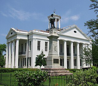
Adams County is a county located in the U.S. state of Mississippi. As of the 2020 census, the population was 29,538. The county seat is Natchez.

<span class="mw-page-title-main">Greene County, Alabama</span> County in Alabama, United States

Greene County is a county located in the west central portion of the U.S. state of Alabama. As of the 2020 census, the population was 7,730, the least populous county in Alabama. Its county seat is Eutaw. It was named in honor of Revolutionary War General Nathanael Greene of Rhode Island.

<span class="mw-page-title-main">Wilkinson County, Mississippi</span> County in Mississippi, United States

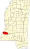
Wilkinson County is a county located in the southwest corner of the U.S. state of Mississippi. As of 2020, its population was 8,587. Its county seat is Woodville. Bordered by the Mississippi River on the west, the county is named for James Wilkinson, a Revolutionary War military leader and first governor of the Louisiana Territory after its acquisition by the United States in 1803.

<span class="mw-page-title-main">Washington County, Mississippi</span> County in Mississippi, United States

Washington County is a county located in the U.S. state of Mississippi. As of the 2020 census, the population was 44,922. Its county seat is Greenville. The county is named in honor of the first president of the United States, George Washington. It is located to the Arkansas border.

<span class="mw-page-title-main">Hinds County, Mississippi</span> County in Mississippi, United States

Hinds County is a county located in the U.S. state of Mississippi. With its county seats, Hinds is the most populous county in Mississippi with a 2020 census population of 227,742 residents. Hinds County is a central part of the Jackson metropolitan statistical area. It is a professional, educational, business and industrial hub in the state. It is bordered on the northwest by the Big Black River and on the east by the Pearl River. It is one county width away from the Yazoo River and the southern border of the Mississippi Delta.

<span class="mw-page-title-main">Franklin County, Mississippi</span> County in Mississippi, United States

Franklin County is a county located in the U.S. state of Mississippi. As of the 2020 census, the population was 7,675. Its county seat is Meadville. The county was formed on December 21, 1809, from portions of Adams County and named for Founding Father Benjamin Franklin. It is bisected by the Homochitto River, which runs diagonally through the county from northeast to southwest.

<span class="mw-page-title-main">Claiborne County, Mississippi</span> County in Mississippi, United States

Claiborne County is a county located in the U.S. state of Mississippi. As of the 2020 census, the population was 9,135. Its county seat is Port Gibson. The county is named after William Claiborne, the second governor of the Mississippi Territory.

<span class="mw-page-title-main">Chickasaw County, Mississippi</span> County in Mississippi, United States

Chickasaw County is a county located in the U.S. state of Mississippi. As of the 2020 census, the population was 17,106. Its county seats are Houston and Okolona. The county is named for the Chickasaw people, who lived in this area for hundreds of years. Most were forcibly removed to Indian Territory in the 1830s, but some remained and became citizens of the state and the United States.

<span class="mw-page-title-main">Benton County, Mississippi</span> County in Mississippi, United States

Benton County is a county located in the U.S. state of Mississippi. As of the 2020 census, the population was 7,646. Its county seat is Ashland.

<span class="mw-page-title-main">Natchitoches Parish, Louisiana</span> Parish in Louisiana, United States

Natchitoches Parish is a parish located in the U.S. state of Louisiana. As of the 2020 census, the population was 37,515. The parish seat and most populous municipality is Natchitoches, the largest by land area is Ashland, and the most density populated area is Campti. The parish was formed in 1805.

<span class="mw-page-title-main">East Carroll Parish, Louisiana</span> Parish in Louisiana, United States

East Carroll Parish is a parish located in the Mississippi Delta in northeastern Louisiana. As of 2020, its population was 7,459. The parish seat is Lake Providence. An area of cotton plantations in the antebellum era, the parish in the early 21st century has about 74% of its land devoted to agriculture.

<span class="mw-page-title-main">Concordia Parish, Louisiana</span> Parish in Louisiana, United States

Concordia Parish borders the Mississippi River in eastern central Louisiana. As of the 2020 census, the population was 18,687. The parish seat is Vidalia. The parish was formed in 1807.

<span class="mw-page-title-main">Lake Village, Arkansas</span> City in Arkansas, United States

Lake Village is a city in and the county seat of Chicot County, Arkansas, United States. The population was 2,575 at the 2010 census. It is located in the Arkansas Delta. Lake Village is named for its location on Lake Chicot, an oxbow lake formed by the Mississippi River.

<span class="mw-page-title-main">Natchez, Mississippi</span> City in Mississippi, United States

Natchez, officially the City of Natchez, is the only city in and the county seat of Adams County, Mississippi, United States. The population was 14,520 at the 2020 census. Located on the Mississippi River across from Vidalia in Concordia Parish, Louisiana, Natchez was a prominent city in the antebellum years, a center of cotton planters and Mississippi River trade.

<span class="mw-page-title-main">Port Gibson, Mississippi</span> City in Mississippi, United States

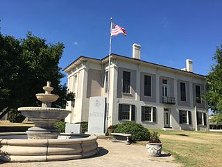
Port Gibson is a city in Claiborne County, Mississippi, United States. The population was 1,567 at the 2010 census. Port Gibson is the county seat of Claiborne County, which is bordered on the west by the Mississippi River. It is the site of the Claiborne County Courthouse.

<span class="mw-page-title-main">Fayette, Mississippi</span> City in Mississippi, United States

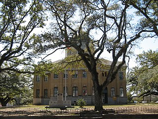
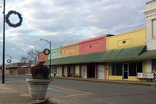
Fayette is a city in Jefferson County, Mississippi, United States. The population was 1,614 at the 2010 census. It is the county seat of Jefferson County.

<span class="mw-page-title-main">David Hunt (planter)</span>

David Hunt was an American planter based in the Natchez District of Mississippi. From New Jersey in approximately 1800, he took a job in his uncle Abijah Hunt's Mississippi business. After his uncle's untimely 1811 death, as a benefeciary and as the executor of the estate, he began to convert the estate into his plantation empire. By the time of the 1860 slave census, Hunt owned close to 800 slaves. This was after ensuring that each of his five adult children had at least one plantation and had an approximate minimum of 100 slaves apiece. In fact, Hunt and his five adult children and their spouses owned some 1,700 slaves by 1860. He became a major philanthropist in the South, contributing to educational institutions in Mississippi, as well as the American Colonization Society and Mississippi Colonization Society, the latter of which he was a founding member.

<span class="mw-page-title-main">Abijah Hunt</span> American planter and slave trader

Abijah Hunt (1762–1811) was an American merchant, planter, slave trader, and banker in the Natchez District.

<span class="mw-page-title-main">1964 United States presidential election in Mississippi</span> Election in Mississippi

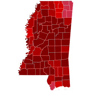
The 1964 United States presidential election in Mississippi was held on November 3, 1964, as part of the 1964 United States presidential election, which was held on that day throughout all fifty states and the District of Columbia. Voters chose seven electors, or representatives to the Electoral College, who voted for president and vice president.

<span class="mw-page-title-main">Old Greenville, Mississippi</span> Ghost town in Jefferson County, Mississippi

Old Greenville is a ghost town in Jefferson County, Mississippi, United States. The town was located along the old Natchez Trace and was once the largest town along the Trace. Nothing exists at the site today except the town's cemetery.

References

  1. "Census - Geography Profile: Jefferson County, Mississippi". United States Census Bureau . Retrieved January 9, 2023.
  2. https://msgw.org/jefferson/
  3. "Find a County". National Association of Counties. Archived from the original on May 31, 2011. Retrieved June 7, 2011.
  4. Gannett, Henry (1905). The Origin of Certain Place Names in the United States. Govt. Print. Off. p. 168.
  5. https://msgw.org/jefferson/
  6. "King: They'll take small victories in struggling Mississippi county." CNN . September 25, 2009, Retrieved September 26, 2009.
  7. "2010 Census Gazetteer Files". United States Census Bureau. August 22, 2012. Archived from the original on September 28, 2013. Retrieved November 4, 2014.
  8. "Annual Estimates of the Resident Population for Counties: April 1, 2020 to July 1, 2023". United States Census Bureau. Retrieved April 5, 2024.
  9. "U.S. Decennial Census". United States Census Bureau. Retrieved November 4, 2014.
  10. "Historical Census Browser". University of Virginia Library. Retrieved November 4, 2014.
  11. "Population of Counties by Decennial Census: 1900 to 1990". United States Census Bureau. Retrieved November 4, 2014.
  12. "Census 2000 PHC-T-4. Ranking Tables for Counties: 1990 and 2000" (PDF). United States Census Bureau. Archived (PDF) from the original on March 27, 2010. Retrieved November 4, 2014.
  13. "State & County QuickFacts". United States Census Bureau. Archived from the original on June 7, 2011. Retrieved September 3, 2013.
  14. "Explore Census Data". data.census.gov. Retrieved December 9, 2021.
  15. "2020 CENSUS - SCHOOL DISTRICT REFERENCE MAP: Jefferson County, MS" (PDF). U.S. Census Bureau. Archived (PDF) from the original on July 31, 2022. Retrieved July 31, 2022. - Text list
  16. Leip, David. "Dave Leip's Atlas of U.S. Presidential Elections". uselectionatlas.org. Retrieved March 4, 2018.
  17. A Guide to the Abijah Hunt Papers, 1800-1821, 1880, The University of Texas at Austin: Briscoe Center for American History

31°44′N91°02′W / 31.73°N 91.03°W / 31.73; -91.03