Related Research Articles

The Xia dynasty is the first dynasty in traditional Chinese historiography. According to tradition, it was established by the legendary figure Yu the Great, after Shun, the last of the Five Emperors, gave the throne to him. In traditional historiography, the Xia was succeeded by the Shang dynasty.

The Yellow River is the second-longest river in China, after the Yangtze River, and the sixth-longest river system on Earth at the estimated length of 5,464 km (3,395 mi). Originating at an elevation above 15,000 feet in the Bayan Har Mountains, it empties into the Bohai Sea. The Yellow River basin was the birthplace of ancient Chinese civilization. Its yellow sediments are carried downstream from the Loess Plateau. The river experiences frequent devastating floods and course changes produced by the continual elevation of the river bed, sometimes above the level of its surrounding farm fields.

The Three Gorges Dam is a hydroelectric gravity dam that spans the Yangtze River near Sandouping in Yiling District, Yichang, Hubei province, central China, downstream of the Three Gorges. The world's largest power station in terms of installed capacity (22,500 MW), the Three Gorges Dam generates 95±20 TWh of electricity per year on average, depending on the amount of precipitation in the river basin. After the extensive monsoon rainfalls of 2020, the dam's annual production reached nearly 112 TWh, breaking the previous world record of ~103 TWh set by Itaipu Dam in 2016.

The Three Gorges are three adjacent and sequential gorges along the middle reaches of the Yangtze River path, in the hinterland of the People's Republic of China. With a subtropical monsoon climate, they are known for their scenery.

Dongting Lake is a large, shallow lake in northeastern Hunan Province, China. It is a flood basin of the Yangtze River, so its volume depends on the season. The provinces of Hubei and Hunan are named after their location relative to the lake: Hubei means "North of the Lake" and Hunan, "South of the Lake".

Yu the Great or Yu the Engineer was a legendary king in ancient China who was famed for "the first successful state efforts at flood control," his establishment of the Xia dynasty which inaugurated dynastic rule in China, and his upright moral character. He figures prominently in the Chinese legend titled "Great Yu Controls the Waters". Yu and other "sage-kings" of ancient China were lauded for their virtues and morals by Confucius and other Chinese teachers. He is one of the few Chinese monarchs who is posthumously honored with the epithet "the Great".
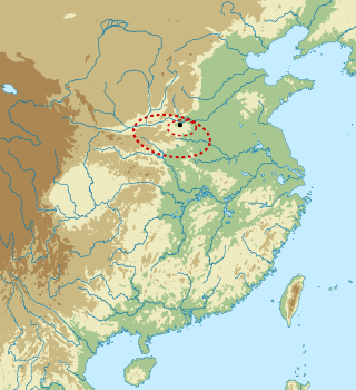
The Erlitou culture was an early Bronze Age society and archaeological culture. It existed in the Yellow River valley from approximately 1900 to 1500 BC. The culture is named after Erlitou, an archaeological site in Yanshi, Henan. It was widely spread throughout Henan and Shanxi and later appeared in Shaanxi and Hubei. Most archaeologists consider Erlitou the first state-level society in China. Chinese archaeologists generally identify the Erlitou culture as the site of the Xia dynasty, but there is no firm evidence, such as writing, to substantiate such a linkage, as the earliest evidence of Chinese writing dates to the Late Shang period.
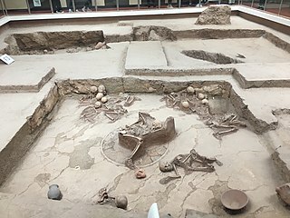
Lajia is a Bronze Age archaeological site in the upper reaches of the Yellow River, on the border between the Chinese provinces of Gansu and Qinghai. As at other sites of the Qijia culture, the people of Lajia had an agricultural economy based primarily on millet cultivation and sheep herding. They also kept pigs for use in ritual activities, including making oracle bones, and experimented with a high temperature-fired pottery described as proto-porcelain. The world's oldest known noodles were discovered at the site in 2005.

The Liujiaxia Dam is a major hydroelectric dam on the upper Yellow River, in Linxia Hui Autonomous Prefecture of China's Gansu Province. The dam and its hydroelectric facility are located in Liujia Gorge, or Liujiaxia, just downstream from where the Tao River flows into the Yellow River. The site is on the eastern outskirts of Liujiaxia Town. Since Liujiaxia Town is the county seat of Yongjing County, it is often marked on less detailed maps simply as "Yongjing".

Xunhua Salar Autonomous County is an autonomous county in the southeast of Haidong Prefecture, in Qinghai province, China. The autonomous county has an area of around 2,100 square kilometres (810 sq mi), and a population of approximately 161,600 inhabitants per a 2022 government publication. In the east it borders the province of Gansu and in the south and the west Huangnan Tibetan Autonomous Prefecture. Its postal code is 811100 and its capital is the town of Jishi.

A glacial lake outburst flood (GLOF) is a type of outburst flood caused by the failure of a dam containing a glacial lake. An event similar to a GLOF, where a body of water contained by a glacier melts or overflows the glacier, is called a jökulhlaup. The dam can consist of glacier ice or a terminal moraine. Failure can happen due to erosion, a buildup of water pressure, an avalanche of rock or heavy snow, an earthquake or cryoseism, volcanic eruptions under the ice, or massive displacement of water in a glacial lake when a large portion of an adjacent glacier collapses into it.

The environmental impact of reservoirs comes under ever-increasing scrutiny as the global demand for water and energy increases and the number and size of reservoirs increases.

A volcanic dam is a type of natural dam produced directly or indirectly by volcanism, which holds or temporarily restricts the flow of surface water in existing streams, like a man-made dam. There are two main types of volcanic dams, those created by the flow of molten lava, and those created by the primary or secondary deposition of pyroclastic material and debris. This classification generally excludes other, often larger and longer lived dam-type geologic features, separately termed crater lakes, although these volcanic centers may be associated with the source of material for volcanic dams, and the lowest portion of its confining rim may be considered as such a dam, especially if the lake level within the crater is relatively high.
A landslide dam or barrier lake is the natural damming of a river by some kind of landslide, such as a debris flow, rock avalanche or volcanic eruption. If the damming landslide is caused by an earthquake, it may also be called a quake lake. Some landslide dams are as high as the largest existing artificial dam.
Jishishan Bonan, Dongxiang and Salar Autonomous County is an autonomous county of Linxia Hui Autonomous Prefecture, in Gansu province, China. It is located in the mostly mountainous area to the south of the Yellow River, near Gansu's border with Qinghai province. The total population was 239,390 in 2020; 64.9% were of an ethnic minority. The county's titular ethnic groups are the Bonan, Dongxiang, and Salar peoples. There are 21,400 Bonan people living in Jishishan, which accounts for 95% of all Bonan in China. The Bonan are known for their cultivation of Sichuan peppers and walnuts. Jishishan's local cuisine includes Bonan-style maisui baozi and lamb meat.

The Wu River is the largest southern tributary of the Yangtze River. Nearly its entire length of 1,150 kilometres (710 mi) runs within the isolated, mountainous and ethnically diverse province of Guizhou. The river takes drainage from a 80,300-square-kilometre (31,000 sq mi) watershed.
Minhe Hui and Tu Autonomous County, known in Tibetan as Kamalog, is the easternmost county in Qinghai Province, China. It is under the administration of Haidong Region. "Hui" refers to the Chinese Muslims, whereas "Tu" refers to the ethnic group known as “Monguor” in the West and as "Tu Zu" in China. It borders the Honggu District of Gansu on the east, demarcated by the Datong River, a tributary to the Huangshui River, which eventually flows into the Yellow River.
Guanting is a town in eastern Qinghai province, China. It is located in the southeast of Minhe County and, together with Guanting, Zhongchuan, Xiakou, Gangou and Xin'er townships, is referred to as the Guanting Area (官亭地区).
The Great Flood of Gun-Yu, also known as the Gun-Yu myth, was a major flood in ancient China that allegedly continued for at least two generations, which resulted in great population displacements among other disasters, such as storms and famine. People left their homes to live on the high hills and mountains, or nest on the trees. According to mythological and historical sources, it is traditionally dated to the third millennium BCE, or about 2300-2200 BCE, during the reign of Emperor Yao.
Twelve Views of Bayu are popular scenic views in and around the city of Chongqing, China. Ba and Yu are old names of Chongqing in Imperial times. Influenced by Eight Views of Xiaoxiang in Hunan Province, people in Chongqing listed their own most beloved views during the reign of the Tianshun Emperor of the Ming dynasty. Scenic views in the list changed throughout the history. Some scenic views appeared in earlier lists no longer exist in modern days due to the change of physical geography, landscapes and land-uses.
References
- 1 2 3 4 5 6 7 8 9 10 11 "Outburst flood at 1920 BCE supports historicity of Chinas Great Flood and the Xia dynasty". Science. 5 August 2016. Retrieved November 7, 2022.
- ↑ "Comment on "Outburst flood at 1920 BCE supports historicity of China's Great Flood and the Xia dynasty"". Science. March 31, 2017. Retrieved November 7, 2022.
- 1 2 "Archaeological discoveries at the Lajia site, Minhe County, Qinghai Province". IA CASS. April 28, 2005. Retrieved November 7, 2022.
- 1 2 "Massive flood may have led to China's earliest empire". Science. August 4, 2016. Retrieved November 7, 2022.
- ↑ "Geologic Evidence May Support Chinese Flood Legend". National Geographic. August 4, 2016. Archived from the original on January 26, 2020. Retrieved November 7, 2022.
- ↑ "《禹貢 - Tribute of Yu》". Chinese Text Project. Book of Documents. March 31, 2017. Retrieved November 7, 2022.
- ↑ "《夏本紀 - Annals of the Xia》". Chinese Text Project. Shiji. March 31, 2017. Retrieved November 7, 2022.
- ↑ "search: 積石". MDBG. March 31, 2017. Retrieved November 7, 2022.
- ↑ "Jishi Gorge 积石峡". Google Maps. March 31, 2017. Retrieved November 7, 2022.