| Jobs Sister | |
|---|---|
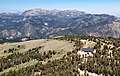
 Southeast aspect | |
| Highest point | |
| Elevation | 10,823 ft (3,299 m) [1] |
| Prominence | 343 ft (105 m) [2] |
| Parent peak | Freel Peak (10,886 ft) [3] |
| Isolation | 0.90 mi (1.45 km) [3] |
| Listing | Tahoe OGUL Peak [4] |
| Coordinates | 38°51′44″N119°53′04″W / 38.8622846°N 119.8843965°W [5] |
| Geography | |
 Jobs Sister Location in California  Jobs Sister Jobs Sister (the United States) | |
| Location | El Dorado / Alpine counties, California, United States |
| Parent range | Sierra Nevada Carson Range |
| Topo map | USGS Freel Peak |
| Geology | |
| Rock age | Late Cretaceous |
| Mountain type | Fault block |
| Rock type | Granodiorite |
| Climbing | |
| Easiest route | class 1 hiking [3] |
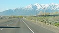
Jobs Sister is a mountain summit located near Lake Tahoe in northern California.