
Corpus Christi is a coastal city in the South Texas region of the U.S. state of Texas and the county seat and largest city of Nueces County, it also extends into Aransas, Kleberg, and San Patricio Counties. It is 130 miles (210 km) southeast of San Antonio. Its political boundaries encompass Nueces Bay and Corpus Christi Bay. Its zoned boundaries include small land parcels or water inlets of three neighboring counties.

U.S. Highway 181 is a south–north U.S. Highway located entirely in the state of Texas. Both termini are at Interstate 37, the road that it mainly parallels to the east. US 181 begins in Corpus Christi, Texas at mile marker 0 to the south, through south-central Texas to just south of San Antonio to the north, for a total length of 137 miles (220 km).

South Texas is a region of the U.S. state of Texas that lies roughly south of—and includes—San Antonio. The southern and western boundary is the Rio Grande, and to the east it is the Gulf of Mexico. The population of this region is about 4.96 million according to the 2017 census estimates. The southern portion of this region is often referred to as the Rio Grande Valley. The eastern portion along the Gulf of Mexico is also referred to as the Coastal Bend.

The Bandra-Worli Sea Link is a 5.6 km long, 8-lane wide bridge that links Bandra in the Western Suburbs of Mumbai with Worli in Central Mumbai. It is the longest sea bridge, as well as the 4th longest bridge in India after Bhupen Hazarika Setu, Dibang River Bridge and Mahatma Gandhi Setu. It is a cable-stayed bridge with pre-stressed concrete-steel viaducts on either side. It was planned as a part of the proposed Western Freeway that would link the Western Suburbs to Nariman Point in Mumbai's main business district, but is now planned to become part of the Coastal Road to Kandivali.

Precast concrete is a construction product produced by casting concrete in a reusable mold or "form" which is then cured in a controlled environment, transported to the construction site and maneuvered into place; examples include precast beams, and wall panels for tilt up construction. In contrast, cast-in-place concrete is poured into site-specific forms and cured on site.

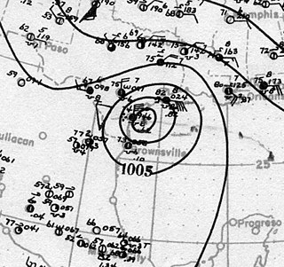
Tropical Storm Arlene brought torrential rainfall to the western United States Gulf Coast, particularly to the U.S. state of Texas, in June 1993. The first named storm of the 1993 Atlantic hurricane season, Arlene developed from an area of low pressure in the Bay of Campeche on June 18. The depression slowly strengthened as it tracked west-northwestward and later north-northwestward across the western Gulf of Mexico. Arlene was subsequently upgraded to a tropical storm on June 19, but failed to intensify further due to its proximity to land. The cyclone then made landfall on Padre Island, Texas, with winds of 40 mph (65 km/h) and degenerated into a remnant disturbance on June 21.

Corpus Christi Bay is a scenic semi-tropical bay on the Texas coast found in San Patricio and Nueces counties, next to the major city of Corpus Christi. It is separated from the Gulf of Mexico by Mustang Island, and is fed by the Nueces River and Oso Creek from its western and southern extensions, Nueces Bay and Oso Bay. The bay is located approximately 136 miles (219 km) south of San Antonio, and 179 miles (288 km) southwest of Houston.

State Highway 361 is a state highway in San Patricio and Nueces counties that runs from Gregory in southern Texas, near Corpus Christi, east and south to Padre Island on the Gulf of Mexico coast.

State Highway 358 is a Texas state highway that runs along the southern edge of Corpus Christi. The access road for Highway 358 is known as South Padre Island Drive (SPID). The official division is FM 665.
Old Bayview Cemetery is a cemetery located on a small hill in downtown Corpus Christi, Texas on Ramirez St. at Padre St., bordered by the I-37 access road. It is the oldest federal military cemetery in Texas. Owned by the City of Corpus Christi, it presently comprises three and a half acres as a Historic Texas Cemetery and a State Archaeological Landmark of the Texas Historical Commission. The cemetery was listed on the National Register of Historic Places in 2020.

The Corpus Christi Harbor Bridge is a through arch bridge located in Corpus Christi, Texas which carries six lanes of U.S. Route 181 (US 181) and Texas State Highway 35 (SH 35) from downtown Corpus Christi to Rincon Point, known to locals as North Beach. The harbor bridge crosses the Corpus Christi Ship Channel and handles nearly 26,000 vehicles daily. A new bridge called the New Harbor Bridge is currently under construction. When complete it will allow larger ships to pass beneath, permit safer pedestrian transit, and reconfigure the entire highway interchange system in the surrounding community.
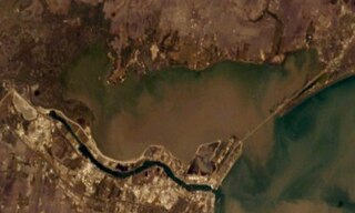
Nueces Bay is a northwestern extension of Corpus Christi Bay in the San Patricio and Nueces Counties of Texas. The bay is fed by the Nueces River, forming a natural estuary, which renders it ecologically and economically vital to the surrounding area. It serves as a habitat for the propagation of fish and shellfish, which sustain diverse species of birds and other wildlife. The bay is threatened by pollution from the heavy industry on its southern shore, which prevents oyster farming. Petrochemical production and oil are important to the surrounding economies of the major settlements of Corpus Christi and Portland, found on the eastern shore and connected by the Nueces Bay Causeway at the bay's confluence with Corpus Christi Bay.

North Padre Island is a barrier island along the coast of Texas. It and South Padre Island were formed after the creation of the Port Mansfield Channel split Padre Island in two. From north to south, North Padre Island is located in parts of Nueces, Kleberg, Kenedy, and Willacy counties. The northernmost part of the island to the Kleberg County line is part of the city of Corpus Christi.
Calallen is a former town that existed until the 1960s. Today, Calallen is a suburb of Corpus Christi. It is located in Nueces County, in the Coastal Bend region of Texas. It is bound to the north by the Nueces River, which also marks the boundary between Nueces County and San Patricio County.

The Laguna Madre is a long, shallow, hypersaline lagoon along the western coast of the Gulf of Mexico in Nueces, Kenedy, Kleberg, Willacy and Cameron Counties in Texas, United States. It is one of seven major estuaries along the Gulf Coast of Texas. The roughly 20-mile (32 km) long Saltillo Flats land bridge divides it into Upper and Lower lagoons joined by the Intracoastal Waterway, which has been dredged through the lagoon. Cumulatively, Laguna Madre is approximately 130 miles (210 km) long, the length of Padre Island in the US. The main extensions include Baffin Bay in Upper Laguna Madre, Red Fish Bay just below the Saltillo Flats, and South Bay near the Mexican border. As a natural ecological unit, the Laguna Madre of the United States is the northern half of the ecosystem as a whole, which extends into Tamaulipas, Mexico approximately 144 miles (232 km) south of the US border, to the vicinity of the Rio Soto La Marina and the town of La Pesca, extending approximately 275 miles (443 km) through USA and Mexico in total.

The San Mateo–Hayward Bridge is a bridge crossing the American state of California's San Francisco Bay, linking the San Francisco Peninsula with the East Bay. The bridge's western end is in Foster City, a suburb on the eastern edge of San Mateo. The eastern end of the bridge is in Hayward. It is the longest fixed-link bridge in California and the 25th longest in the world by length. The bridge is owned by the state of California, and is maintained by California Department of Transportation (Caltrans), the state highway agency. Further oversight is provided by the Bay Area Toll Authority (BATA).

A launching gantry is a special-purpose mobile gantry crane used in bridge construction, specifically segmental bridges that use precast box girder bridge segments or precast girders in highway and high-speed rail bridge construction projects. The launching gantry is used to lift and support bridge segments or girders as they are placed while being supported by the bridge piers instead of the ground.
The following is a timeline of the history of the city of Corpus Christi, Texas, USA.
The Harbor Bridge Project is the replacement of the existing through arch bridge that crosses the Corpus Christi Ship Channel, which serves the Port of Corpus Christi in Corpus Christi, Texas, with a modern cable-stayed bridge design. The route will connect with SH 286 at its southern terminus and US 181 on the north. Groundbreaking on construction took place on August 8, 2016 and was scheduled to be completed by the spring of 2020, but was extensively delayed due to engineering and design issues, and is tentatively planned to be completed in 2025.
The effects of the 1919 Florida Keys hurricane in Texas were the deadliest of any tropical cyclone in the Texas Coastal Bend, killing at least 284 people. The hurricane produced a widespread swath of devastation across the region, exacerbated by the large extent of its winds. The city of Corpus Christi bore the brunt of the hurricane's impacts, contributing to the largest portion of the damage toll in Texas; nearly all of the confirmed fatalities were residents of the city. The storm originated from the Leeward Islands early in September 1919 and took a generally west-northwestward course, devastating the Florida Keys en route to the Gulf of Mexico. On the afternoon of September 14, the center of the hurricane made landfall upon the Texas coast at Baffin Bay. The storm's winds were estimated at 115 mph (185 km/h) at landfall, making it a Category 3 hurricane on the Saffir–Simpson hurricane wind scale. After slowly moving ashore, it weakened and straddled the Rio Grande before dissipating on September 16 over West Texas.

