
Southport is a census-designated place (CDP) in the town of Fairfield, Connecticut. It is located along Long Island Sound between Mill River and Sasco Brook, where it borders Westport. As of the 2020 census, it had a population of 1,710. Settled in 1639, Southport center has been designated a local historic district since 1967. In 1971, it was listed on the National Register of Historic Places as the Southport Historic District.

This is intended to be a complete list of the properties and districts on the National Register of Historic Places in Fairfield County, Connecticut, United States. The locations of National Register properties and districts for which the latitude and longitude coordinates are included below may be seen in an online map.

Fairfield station is a commuter rail station on the Metro-North Railroad New Haven Line, located in Fairfield, Connecticut. The former station buildings are listed on the National Register of Historic Places as Fairfield Railroad Stations.

New London Harbor Light is a lighthouse in Connecticut on the west side of the New London harbor entrance. It is the nation's fifth oldest light station and the seventh oldest U.S. lighthouse. It is both the oldest and the tallest lighthouse in Connecticut and on Long Island Sound, with its tower reaching 90 feet.
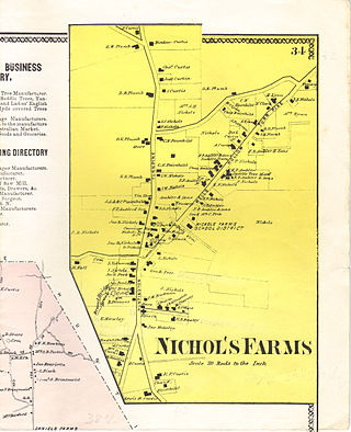
Nichols Farms is a historic area within the town of Trumbull, Connecticut. The Nichols Farms Historic District, which encompasses part of the area, is listed on the National Register of Historic Places.

The John Rider House is located on Main Street in Danbury, Connecticut, United States. It is a wooden frame house dating to the late 18th century.
Preston City is a village and the original town center of the town of Preston, Connecticut. The core of the village around the junction of Old Northwest Road and Route 164 is designated as the Preston City Historic District, a historic district that is listed on the National Register of Historic Places. The district is located along Old Shetucket and Amos Roads, which, prior to the 1930s, were major thoroughfares.

The Fairfield Historic District encompasses the historic town center of Fairfield, Connecticut, roughly along Old Post Road between U.S. Route 1 and Turney Road. The area contains Fairfield's town hall, public library, and houses dating from the late 18th century, and includes portions of the town's earliest colonial settlement area. The district was listed on the National Register of Historic Places in 1971.

The Southport Historic District in the town of Fairfield, Connecticut is a 225-acre (91 ha) area historic district that was listed on the National Register of Historic Places in 1971. It preserves a portion of the modern neighborhood and former borough of Southport, Connecticut. Since the British burnt almost all of Southport's structures in 1779, there is only one home built prior to that date, the Meeker House at 824 Harbor Road, which survives.

The Pequot Fort was a fortified Native American village in what is now the Groton side of Mystic, Connecticut, United States. Located atop a ridge overlooking the Mystic River, it was a palisaded settlement of the Pequot tribe until its destruction by Puritan and Mohegan forces in the 1637 Mystic massacre during the Pequot War. The exact location of its archaeological remains is not certain, but it is commemorated by a small memorial at Pequot Avenue and Clift Street. The site previously included a statue of Major John Mason, who led the forces that destroyed the fort; it was removed in 1995 after protests by Pequot tribal members. The archaeological site was added to the National Register of Historic Places in 1990.
The Bradley-Hubbell House is an historic house located at 535 Black Rock Turnpike in Easton, Connecticut. Built in 1816 for Aljah and Elizabeth Bradley, it is a Colonial with a traditional center-chimney plan and a few Federal-style ornaments, including oval windows in the gables, a parlor mantel, and rope molding on the stairs. In 1912, Bradley descendants sold the property to the Bridgeport Hydraulic Company, which flooded much of the farmland for a reservoir and leased the house to Franklin Hubbell, one of its employees. In 1998, the house was donated to the Easton Historical Society, which is restoring it.
The Osborne Homestead is a two-story colonial revival house located in Osbornedale State Park, in the Derby Neck section of the city of Derby, Connecticut. The homestead is listed on the National Register of Historic Places and is operated as a museum by the State of Connecticut. It is significant for being the home of Frances Osborne Kellogg, a proponent for equal professional opportunities for women in Connecticut.

The Caleb Baldwin Tavern is a historic house at 32 Main Street in the Newtown Borough Historic District in Newtown, Connecticut, built around 1763. The two-and-a-half-story house is considered historically significant for its role in movement of French Army forces under General Rochambeau, as it housed some of the army's officers in June 1781 on their march to the Siege of Yorktown. It is also an example of traditional 18th-century New England architecture and retains some details from that time period. It was listed on the National Register of Historic Places on August 23, 2002.

The Bradley Edge Tool Company Historic District encompasses the surviving remnants of a historic 19th-century industrial village in Weston, Connecticut. Extending along Lyons Plain Road near White Birch Road and the Saugatuck River, the area was home to the Bradley Edge Tool Company, which flourished here between 1834 and 1870. The principal surviving elements are residences which were built for the owners and workers of the company; the factory itself burned in 1911. The district was listed on the National Register of Historic Places in 1995.

The Samuel Smith House is a historic First Period house at 82 Plants Dam Road in East Lyme, Connecticut. With a construction history dating to about 1700, it is one of the oldest buildings in the community, exhibiting a pattern of architectural changes over the 18th century. The house was added to the National Register of Historic Places on June 4, 1979.

The John Glover House is a historic house at 53 Echo Valley Road in Newtown, Connecticut, USA. Built about 1708 by an early town settler, it is a remarkably well-preserved example of 18th-century residential architecture, owned for generations by a locally prominent farming family. The house was listed on the National Register of Historic Places in 2001.

The Kettle Creek Historic District encompasses one of the earliest settlement areas of the town of Weston, Connecticut. It consists of a small crossroads village center, extending north from the junction of Weston Road and Broad Street to the junction with Old Weston Road, and includes a small number of well-preserved 18th and 19th-century houses. It was listed on the National Register of Historic Places in 1985.
This is a list of the properties and historic districts in Stamford, Connecticut that are listed on the National Register of Historic Places. The locations of National Register properties and districts for which the latitude and longitude coordinates are included below, may be seen in an online map.

St. John's Episcopal Church is a historic church at 768 Fairfield Avenue in Bridgeport, Connecticut. Built in 1873 for a congregation founded in the mid-18th century, it is a well-preserved design of James Renwick, Jr. and a good example of late 19th-century Gothic Revival archiecture. It was listed on the National Register in 1984.
Osborne House may refer to:


