Related Research Articles

The Humboldt River is an extensive river drainage system located in north-central Nevada. It extends in a general east-to-west direction from its headwaters in the Jarbidge, Independence, and Ruby Mountains in Elko County, to its terminus in the Humboldt Sink, approximately 225 miles (362 km) away in northwest Churchill County. Most estimates put the Humboldt River at 300 to 330 miles long; however, due to the extensive meandering nature of the river, its length may be more closely estimated at 380 miles (610 km). It is located within the Great Basin Watershed and is the third-longest river in the watershed behind the Bear River at 355 miles (571 km) and the Sevier River at 325 miles (523 km). The Humboldt River Basin is the largest sub-basin of the Great Basin, encompassing an area of 16,840 square miles (43,600 km2). It is the only major river system wholly contained within the state of Nevada.

Humboldt Bay is a natural bay and a multi-basin, bar-built coastal lagoon located on the rugged North Coast of California, entirely within Humboldt County, United States. It is the largest protected body of water on the West Coast between San Francisco Bay and Puget Sound, the second-largest enclosed bay in California, and the largest port between San Francisco and Coos Bay, Oregon. The largest city adjoining the bay is Eureka, the regional center and county seat of Humboldt County, followed by the city of Arcata. These primary cities, together with adjoining unincorporated communities and several small towns, comprise a Humboldt Bay Area with a total population of nearly 80,000 people. This comprises nearly 60% of the population of Humboldt County. The bay is home to more than 100 plant species, 300 invertebrate species, 100 fish species, and 200 bird species. In addition, the bay and its complex system of marshes and grasses support hundreds of thousands of migrating and local shore birds. Commercially, this second-largest estuary in California is the site of the largest oyster production operations on the West Coast, producing more than half of all oysters farmed in California.

Garberville is a census-designated place in Humboldt County, California. It is located on the South Fork of the Eel River 52 miles (84 km) south-southeast of Eureka, at an elevation of 535 feet (163 m). The population was 913 at the 2010 United States Census. It is approximately 200 miles (320 km) north of San Francisco, California, and within a fifteen-minute drive to Humboldt Redwoods State Park and a sixty-minute drive to Eureka, the county seat. Garberville is the primary town in the area known as the Mateel Region, consisting of parts of the Mattole and Eel River watersheds in southern Humboldt and northern Mendocino counties.

Fern Canyon is a canyon in the Prairie Creek Redwoods State Park in Humboldt County, California, western United States. The park is managed in cooperation with other nearby redwoods state parks and Redwood National Park. It is named for the ferns growing on the 50-foot (15 m) high walls, through which runs Home Creek. Fern Canyon is recognized as a World Heritage Site and an International Biosphere Reserve.

Bayside is an unincorporated community 2.25 miles (3.6 km) south-southeast of Arcata, at an elevation of 33 feet in Humboldt County, California. The ZIP Code is 95524, the area code is 707. The relatively large area was originally covered by large, ancient Coast Redwood trees down to what was the edge of a significantly larger Humboldt Bay at high tide. Later, the mammoth redwoods made it the natural placement of some of the area's earliest redwood lumber operations. A rock quarry was located in the area's hills, which form the beginning of the Coast Ranges, the source of water for an early public water system for the City of Arcata. Today, Bayside provides Arcata a buffer from Eureka's northward expansion along US Route 101 and the area, with the exception of some business and public buildings, is largely rural, with homes and small ranches dotting the landscape. Second growth forests exist mostly apart from cleared lands, which show some evidence of the extensive redwood forest that once existed in the form of large stumps. Some of the area's older Victorian era houses, are still present on the Old Arcata Road, the original main road connecting Arcata to Eureka. Jacoby Creek runs alongside a road of the same name from the hills in the direction of the Bay.

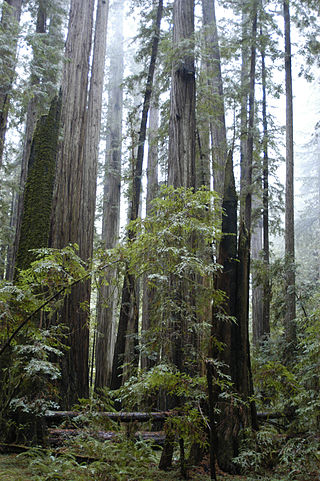
The Arcata Community Forest is part of the parks and recreation system of the City of Arcata, California, United States. It was originally created in 1955 from six forest tracts: Gannon Tract, Burns Tract, Preston Tract I, Preston Tract II, Reclamation Water Co. Tract, and Brizard Tract. The main forest area covers 793 acres (3.21 km2). The park was the culmination of efforts to combine tracts of forest land located east of the city together in one continuous section of city-owned second-growth coast redwood forest. Over a 50-year period, 622 acres (2.52 km2) were obtained in several purchases. In November 2006, the 171-acre (0.69 km2) Sunny Brae Forest was added to the Community Forest. The city also owns and manages the 1,200-acre (4.9 km2) Jacoby Creek Forest. The City owns a total of 2,134 acres (8.64 km2) of forest."
Bull Creek is a locality 11 miles (18 km) south-southeast of Scotia, at an elevation of 7 feet (2.1 m) in Humboldt County, California. Bull Creek Road parallels Bull Creek and is also known as the Mattole Road.
Crannell is a former settlement in Humboldt County, California. It is located 4.5 miles (7.2 km) southeast of Trinidad, at an elevation of 203 feet (62 m).
Elk River is an unincorporated community in Humboldt County, California. It is located 2.25 miles (3.6 km) east-northeast of Fields Landing, at an elevation of 69 feet. All the residents of this neighborhood have Eureka, California addresses.
Fairhaven is an unincorporated community and census-designated place (CDP) adjacent to Humboldt Bay in Humboldt County, California, United States. It is located 2.25 miles (3.6 km) west-southwest of downtown Eureka, at an elevation of 10 feet (3.0 m) above sea level.
Freshwater is an unincorporated community in Humboldt County, California. It is located on Freshwater Creek, a major tributary to Humboldt Bay, 7.5 miles (12 km) south of Arcata, at an elevation of 92 feet. The area is the site of a now logged massive old-growth redwood forest and prevalent remaining second-growth forest. The trees in the area are storied to have been some of the largest coast redwoods to have ever existed. On September 24, 1964, the large area and all its residents became part of unincorporated Eureka, within the 95503 zipcode. Freshwater Park, a Humboldt County Park, which has picnic areas and a swimming area each summer, is located nearby on Freshwater Creek.
Fruitland is an unincorporated community in Humboldt County, California. It is located 6 miles east-southeast of Weott, at an elevation of 1,004 feet (306 m).

Oketo is a former Yurok settlement in Humboldt County, California, but experts differ on what the names were of the settlement itself and of the nearby waterway now called Big Lagoon. Yurok author Chenahwah Weitchahwah used the name Ah-ca-tah when mentioning the location of a religious practice but was unclear whether she was naming the village or lagoon. Peter Palmquist placed the village at the south shore of the lagoon. A. L. Kroeber said the village was called Opyuweg, mapping it in more detail. T. T. Waterman said the lagoon was named Oketo and pinpointed the village most precisely as Opyuweg, setting it west of a southern promontory of the lagoon and of a settlement called piNpa. Coastal Yuroks call themselves Ner-'er-'ner or Ner-er-ner and upriver Yuroks call themselves Pue-lik-lo' or Polikla. In his notes, C. H. Merriman recorded that Oketo was the name the Polikla or Pue-lik-lo' used for a Ner-er-ner village at Big Lagoon.
Table Bluff is a locality in Humboldt County, California. It is located adjacent to the Pacific Ocean 4.5 miles (7.2 km) south of Fields Landing, at an elevation of 318 feet (97 m).
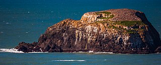
Trinidad Head is a rocky promontory surrounded by sea stacks sheltering Trinidad Harbor, adjacent to the town of Trinidad in Humboldt County, California, USA, designated as California Historical Landmark #146.

The Little River is a river in the U.S. state of California, whose drainage basin is the largest on the Pacific coast between the Mad River and Big Lagoon. The 19.6-mile (31.5 km) river drains the forested Franciscan assemblage of the California Coast Ranges.
Widow White Creek is a small tributary of Norton Creek in McKinleyville, California, that lies just south of the Arcata-Eureka Airport in Humboldt County. In 2014 the North Coast regional water board recommended that Widow White Creek be listed as an impaired waterway due to E. coli contamination 600 times greater than normal.
The Elk River is a river in the U.S. state of California, originating at 2,000 feet (610 m) elevation in forested highlands southeast of Eureka, California. The north and south forks combine to flow 15 miles (24 km) into Humboldt Bay on the south edge of Eureka. The river was called Ka-sha-reh by the Wiyot people, but received its present name after Josiah Gregg's party enjoyed a meal of elk meat near the river on Christmas, 1849.
Campbell Creek is a tributary in rural north Humboldt County, California near Willow Creek. It flows north into the Trinity River. In 2014 the North Coast regional water board recommended that Campbell Creek be listed and an impaired waterway due to E. coli contamination 600 times greater than normal
Freshwater Creek is a 23 kilometres (14 mi) long creek in Humboldt County, California that is a tributary of the Eureka Slough that in turn feeds Humboldt Bay. It flows into the south-east corner of the Arcata Bay sub-bay of Humboldt Bay. Its downstream reach is also known as Freshwater Slough and its upstream reach as Freshwater Gulch.
References
- ↑ Turner, Dennis (1993). Places Names of Humboldt County, California. Orangevale, CA: Dennis W. Turner. p. 122. ISBN 0-9629617-1-X.
- ↑ "Archived copy" (PDF). Archived from the original (PDF) on 2015-11-20. Retrieved 2015-04-29.
{{cite web}}: CS1 maint: archived copy as title (link) - ↑ "Six local Humboldt County waterways under attack: Over 600 times healthy bacteria level detected in creek - Humboldt Baykeeper".
40°51′22″N124°05′26″W / 40.8562°N 124.0906°W
| | This Humboldt County, California–related article is a stub. You can help Wikipedia by expanding it. |