Description
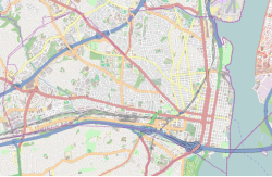
The Woodrow Wilson Bridge crosses the park, most of which is under the jurisdiction of the National Park Service. The Mount Vernon Trail travels through the park. [4]
The City of Alexandria had hosted many anniversary celebrations, starting in the 1980s, [5] centered around its anniversary on July 10, at Jones Point, including its 250th in 1999, and often featuring a fireworks display. [6] Beginning in 2002, they have been largely held at Oronoco Bay Park, located further north along the Potomac. [7]
Jones Point underwent a major renovation, completed in 2012, which included National Park Service placards along walking and biking trails highlighting its history. Other improvements include larger parking lots, a basketball court, a playground, a concession stand, restrooms, new walking and bike paths, small fishing/sightseeing piers, and easy access to the Jones Point lighthouse. [4] The National Park Service and others have erected in and near the park a number of markers that relate the history of Jones Point and its surroundings. [8] One of the few visible remnants of the shipyard is the fitting-out dock, next to which is a grass lawn bound by a concrete retaining wall representing the length and width of SS Gunston Hall's hull. [9]

Arlington County, or simply Arlington, is a county in the U.S. state of Virginia. The county is located in Northern Virginia on the southwestern bank of the Potomac River directly across from Washington, D.C., the national capital.
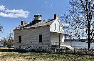
The Jones Point Light is a small river lighthouse located on the Potomac River in Alexandria, Virginia. It was built in 1855.
The Potomac Heritage Trail, also known as the Potomac Heritage National Scenic Trail or the PHT, is a designated National Scenic Trail corridor spanning parts of the mid-Atlantic region of the United States that will connect various trails and historic sites in Virginia, Maryland, Pennsylvania, and the District of Columbia. The trail network includes 710 miles (1,140 km) of existing and planned sections, tracing the natural, historical, and cultural features of the Potomac River corridor, the upper Ohio River watershed in Pennsylvania and western Maryland, and a portion of the Rappahannock River watershed in Virginia. The trail is managed by the National Park Service and is one of three National Trails that are official NPS units.

The George Washington Memorial Parkway, colloquially the G.W. Parkway, is a 25-mile-long (40 km) parkway that runs along the south bank of the Potomac River from Mount Vernon, Virginia, northwest to McLean, Virginia, and is maintained by the National Park Service (NPS). It is located almost entirely within Virginia, except for a short portion of the parkway northwest of the Arlington Memorial Bridge that passes over Columbia Island within the District of Columbia.

The history of Washington, D.C., is tied to its role as the capital of the United States. The site of the District of Columbia along the Potomac River was first selected by President George Washington. The city came under attack during the War of 1812 in an episode known as the Burning of Washington. Upon the government's return to the capital, it had to manage the reconstruction of numerous public buildings, including the White House and the United States Capitol. The McMillan Plan of 1901 helped restore and beautify the downtown core area, including establishing the National Mall, along with numerous monuments and museums.

Washington, D.C. is located in the Mid-Atlantic region of the United States at 38°53′42″N77°02′11″W, the coordinates of the Zero Milestone, on The Ellipse. According to the United States Census Bureau, the city has a geographical area of 68.3 square miles (176.9 km2), 61.4 square miles (159.0 km2) of which is land, and the remaining 6.9 square miles (17.9 km2) (10.16%) of which is water. The Anacostia River and the smaller Rock Creek flow into the Potomac River in Washington.

The Mount Vernon Trail (MVT) is an 18-mile (29 km) long shared use path that travels along the George Washington Memorial Parkway in Northern Virginia between Rosslyn and George Washington's home at Mount Vernon. The trail connects the easternmost portions of Arlington County, the City of Alexandria, and Fairfax County, and travels mostly on dedicated trail with a small portion on city streets. As part of U.S. Bike Route 1, the Potomac Heritage Trail and the East Coast Greenway, the MVT opened in April 1972 as a gravel path and was subsequently expanded and paved.
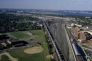
Potomac Yard is a neighborhood in Northern Virginia that straddles southeastern Arlington County and northeastern Alexandria, Virginia, located principally in the area between U.S. Route 1 and the Washington Metro Blue Line /Yellow Line tracks. The area was home to what was once one of the busiest rail yards on the Eastern Seaboard of the United States. The "Potomac Yard" name is also used to refer to several developments in the area, especially the Potomac Yard Center power center and a Washington Metro station.

Four Mile Run is a 9.4-mile-long (15.1 km) stream in Northern Virginia that starts near Interstate 66, at Gordon Avenue in Fairfax County and proceeds southeast through Falls Church to Arlington County in the U.S. state of Virginia. Most of the stretch is parkland and is paralleled by two paved non-motorized transport and recreational trails, the Washington & Old Dominion Railroad Trail and the Four Mile Run Trail.

The boundary markers of the original District of Columbia are the 40 milestones that marked the four lines forming the boundaries between the states of Maryland and Virginia and the square of 100 square miles (259 km2) of federal territory that became the District of Columbia in 1801. Working under the supervision of three commissioners that President George Washington had appointed in 1790 in accordance with the federal Residence Act, a surveying team led by Major Andrew Ellicott placed these markers in 1791 and 1792. Among Ellicott's assistants were his brothers Joseph and Benjamin Ellicott, Isaac Roberdeau, George Fenwick, Isaac Briggs and an African American astronomer, Benjamin Banneker.

Colin Hamilton Livingstone was an American banker and a president of the Washington and Old Dominion Railway, the Virginia Shipbuilding Corporation in Alexandria, and the Washington and Virginia Real Estate Company. He was also the first national president of the Boy Scouts of America (BSA).

The Alexandria Historic District is a National Historic Landmark District in Alexandria, Virginia. Encompassing all of the city's Old Town and some adjacent areas, this area contains one of the nation's best-preserved assemblages of the late-18th and early-19th century urban architecture. The district was declared a National Historic Landmark in 1966.
Alexandria is an independent city in the northern region of the Commonwealth of Virginia, United States. It lies on the western bank of the Potomac River approximately 7 miles (11 km) south of downtown Washington, D.C. Alexandria is the third largest "principal city" of the Washington metropolitan area which is part of the larger Washington-Baltimore combined statistical area.

Aquia Creek sandstone is a brown to light-gray freestone used extensively in building construction in Washington, D.C. in the late 18th and early 19th centuries. Quarried at Aquia Creek in Stafford County, Virginia, the stone was valuable for its ease of shaping and the quarry's proximity to the tidewater portion of the Potomac River, 45 miles (72 km) south of Washington.

The Public Quarry at Government Island in Stafford County, Virginia is the principal source of Aquia Creek sandstone, a building stone used in many of the early government buildings in Washington, D.C., including the U.S. Capitol and the White House. A quarry was established just off the Potomac River at Wigginton's Island on Aquia Creek by George Brent after 1694, providing stone for tombstones and to houses and churches in northern Virginia, including Gunston Hall, Christ Church in Alexandria, Virginia, Mount Airy in Richmond County, Virginia, and Aquia Church, as well as steps and walkways at George Washington's Mount Vernon. Washington selected Aquia sandstone as the primary material for use in Washington's government buildings. Acting on the government's behalf, the Wigginton's Island quarry was purchased by Pierre Charles L'Enfant in 1791, becoming known afterward as Government Island.
The USCGC Lilac (WAGL/WLM-227) is a former Coast Guard buoy tender which is now a museum ship located in New York City. Lilac is America's only surviving steam-powered buoy tender, and is listed on the National Register of Historic Places.

The history of Alexandria, Virginia, begins with the first European settlement in 1695. Over the next century, the town became a significant port. In 1801, much of Alexandria was swept into the new District of Columbia; it was damaged along with much of the rest of the capital during the War of 1812. In 1846, Alexandria was returned to Virginia, along with the rest of the District's territory on the western side of the Potomac River. After Virginia seceded in 1861, Alexandria was swiftly captured by Union forces and held for the remainder of the American Civil War. In the late 20th century, Alexandria became a key part of the rapidly growing Northern Virginia region.
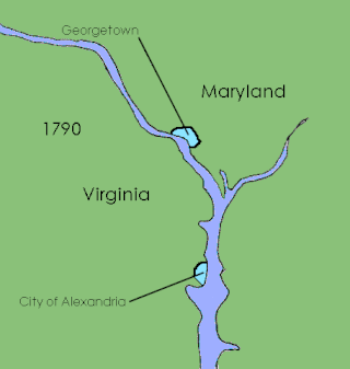
The District of Columbia was created in 1801 as the federal district of the United States, with territory previously held by the states of Maryland and Virginia ceded to the federal government of the United States for the purpose of creating its federal district, which would encompass the new national capital of the United States, the City of Washington. The district came into existence, with its own judges and marshals, through the District of Columbia Organic Act of 1801; previously it was the Territory of Columbia. According to specific language in the U.S. Constitution, it was 100 square miles (259 km2).

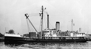
SS Gunston Hall was a Design 1015 steel-hulled cargo ship built in 1919 by the Virginia Shipbuilding Corporation for the United States Shipping Board's Emergency Fleet Corporation. Initially intended for service in World War I, Gunston Hall was not completed until after the war's end. The ship was sold for scrap in 1930.