Related Research Articles

St. Louis Regional Airport is a public airport four miles (6 km) east of Alton, in Madison County, Illinois, United States. It is in the village of Bethalto but its mailing address is East Alton.

North Las Vegas Airport is a public-use airport 3 mi (4.8 km) northwest of downtown Las Vegas in North Las Vegas, Nevada. It is owned by the Clark County Commission and operated by the Clark County Department of Aviation.
Clinton County Airport is a former county-owned public-use airport in Clinton County, New York, United States. It is located 3 nautical miles west of the central business district of the city of Plattsburgh. It served Plattsburgh and the western side of Lake Champlain.
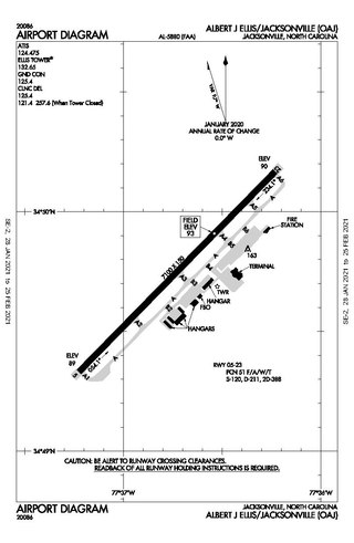
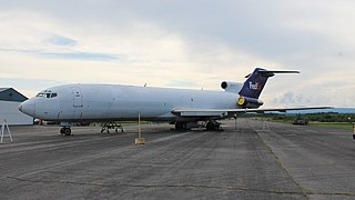
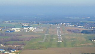
Albert J. Ellis Airport is a county-owned public-use airport in Onslow County, North Carolina, United States. It is located in Richlands, 10 nautical miles (19 km) northwest of the central business district of Jacksonville and Marine Corps Base Camp Lejeune. The airport has a single runway and three gates. Opening on February 15, 1971, the airport is used by general aviation, the military and two commercial airlines, American Eagle and Delta Connection.

Phoenix Goodyear Airport is a public airport in Goodyear, Arizona in Maricopa County, Arizona, United States.

Marana Regional Airport, also known as Marana Northwest Regional Airport or Avra Valley Airport, is a non-towered, general aviation airport about 15 miles northwest of Tucson, Arizona in Marana a town in Pima County, Arizona, United States. In 1999, the airport was purchased from Pima County by the town of Marana.

The Pompano Beach Airpark is a public airport located one mile (1.6 km) northeast of the central business district of Pompano Beach, in Broward County, Florida, United States. The airport is publicly owned by the City of Pompano Beach.
Wellsville Municipal Airport, also known as Tarantine Field, is a public use airport located 2 nautical miles southwest of Wellsville, a village in the Town of Wellsville, Allegany County, New York, United States. The airport is owned by the Town of Wellsville. It is included in the National Plan of Integrated Airport Systems for 2011–2015, which categorized it as a general aviation facility.

Danbury Municipal Airport is a public use general aviation and commercial airport located three miles (5 km) southwest of the central business district of Danbury, in Fairfield County, Connecticut, United States. The airport opened in 1930. It is currently run by the City of Danbury under the management of Michael Safranek. It is included in the Federal Aviation Administration (FAA) National Plan of Integrated Airport Systems for 2017–2021, in which it is categorized as a regional reliever airport facility.

Brookhaven Calabro Airport is a public airport located one mile (1.6 km) north of the central business district of Shirley, in Suffolk County, New York, United States. This airport is publicly owned by the Town of Brookhaven.

Treasure Coast International Airport is a public airport located three miles (5 km) northwest of the central business district of Fort Pierce, a city in St. Lucie County, Florida, United States. It is owned by the St. Lucie Board of County Commissioners.
Morrisville–Stowe State Airport is a public airport located two miles (3 km) southwest of the central business district of Morrisville, a village in Lamoille County, Vermont, United States. It is owned by the State of Vermont. The airport had scheduled passenger airline service via Air Vermont in the 1980s.
Chester County G. O. Carlson Airport is a public airport two miles (3 km) west of Coatesville, in Valley Township, Chester County, Pennsylvania. It is owned by the Chester County Area Airport Authority.
Easton Airport, also known as Easton/Newnam Field, is a county-owned, public-use airport located two nautical miles north of the central business district of Easton, a town in Talbot County, Maryland, United States.
Mount Pleasant Municipal Airport is a city-owned public-use airport located two miles (3 km) northeast of the central business district of Mount Pleasant, a city in Isabella County, Michigan, United States. The airport became active in 1940. It serves general aviation for Mount Pleasant and the surrounding area. It is included in the Federal Aviation Administration (FAA) National Plan of Integrated Airport Systems for 2017–2021, in which it is categorized as a local general aviation facility.
Tok Junction Airport is a state-owned public-use airport located one nautical mile east of the central business district of Tok, in the Southeast Fairbanks Census Area of the U.S. state of Alaska.

Middlebury State Airport is a public use airport in Addison County, Vermont, United States. It is owned by the State of Vermont and is located three nautical miles (5.56 km) southeast of the central business district of the Town of Middlebury.
Corning–Painted Post Airport is a public use airport in Steuben County, New York, United States. It is located two nautical miles (4 km) northwest of the central business district of Corning. The airport is owned by the Town of Erwin and located near Painted Post, New York. It is included in the National Plan of Integrated Airport Systems for 2011–2015, which categorized it as a general aviation facility.
Cortland County Airport, is located west of Cortland, New York, United States. It was formerly named Cortland Municipal Airport.
References
- ↑ FAA Airport Form 5010 for N89 PDF , effective 2010-11-18
- ↑ "AirportIQ 5010". www.gcr1.com. Archived from the original on 2012-10-22.
- ↑ "AirNav: N89 - Joseph y Resnick Airport".
| | This article about an airport in New York is a stub. You can help Wikipedia by expanding it. |