| Jubba River | |
|---|---|
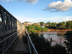
 The Jubba river near Jamaame | |
 Map of the Jubba/Shebelle drainage basin | |
| Native name | نهر جوبا (Arabic) |
| Location | |
| Countries | |
| Physical characteristics | |
| Source | |
| • location | Ganale Dorya River |
| • coordinates | 6°48′45″N39°07′14″E / 6.812476°N 39.120654°E |
| • length | 1,634 km (1,015 mi) |
| • elevation | 3,588 m (11,772 ft) |
| 2nd source | |
| • location | Dawa River |
| • coordinates | 6°13′35″N38°24′30″E / 6.226442°N 38.408440°E |
| • length | 1,614 km (1,003 mi) |
| • elevation | 3,023 m (9,918 ft) |
| 3rd source | |
| • location | Shebelle River |
| • coordinates | 6°51′14″N38°41′14″E / 6.853955°N 38.687357°E |
| • length | 2,064 km (1,283 mi) |
| • elevation | 2,711 m (8,894 ft) |
| Source confluence | |
| • location | Confluence of Dawa River and Ganale Dorya River |
| • coordinates | 4°10′38″N42°04′51″E / 4.1771°N 42.0809°E |
| • elevation | 174 m (571 ft) |
| Mouth | Somali Sea |
• location | Goobweyn |
• coordinates | 0°14′58″S42°37′51″E / 0.2495°S 42.6307°E |
• elevation | 0 m (0 ft) |
| Length | 2,064 km (1,283 mi) [1] |
| Basin size | 745,374 km2 (287,791 sq mi) |
| Discharge | |
| • location | Mouth |
| • average | 536.7 m3/s (18,950 cu ft/s) |
| • minimum | 179.2 m3/s (6,330 cu ft/s) |
| • maximum | 1,055.7 m3/s (37,280 cu ft/s) |
| Basin features | |
| Population | 27,100,000 [2] |
| Tributaries | |
| • left | Ganale Dorya, Shebelle |
| • right | Dawa, Ewaso Ng'iro |
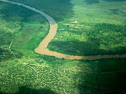
The Jubba River or Juba River (Somali : Webiga Jubba, Italian : fiume Giuba) is a river in southern Somalia which flows through the region of Jubaland. It begins at the border with Ethiopia, where the Dawa and Ganale Dorya rivers meet, and flows directly south to the Somali Sea, where it empties at the Goobweyn juncture. The Jubba basin covers an area of 749,000 km2 (289,000 sq mi). [3] The Somali regional state of Jubaland, formerly called Trans-Juba, is named after the river.