
Tropical Storm Allison was a tropical storm that devastated southeast Texas in June of the 2001 Atlantic hurricane season. An arguable example of the "brown ocean effect", Allison lasted unusually long for a June storm, remaining tropical or subtropical for 16 days, most of which when the storm was over land dumping torrential rainfall. The storm developed from a tropical wave in the northern Gulf of Mexico on June 4, 2001, and struck the upper Texas coast shortly thereafter. It drifted northward through the state, turned back to the south, and re-entered the Gulf of Mexico. The storm continued to the east-northeast, made landfall on Louisiana, then moved across the southeast United States and Mid-Atlantic. Allison was the first storm since Tropical Storm Frances in 1998 to strike the northern Texas coastline.

Hurricane Hilda was an intense tropical cyclone that ravaged areas of the United States Gulf Coast, particularly Louisiana. In addition to its damage inland, the hurricane greatly disrupted offshore oil production, and at its time was the costliest tropical cyclone for Louisiana's offshore oil production. Due in part to flights made by the National Hurricane Research Laboratory, Hilda became one of the most well-documented storms meteorologically in the Atlantic. Lasting for seven days as a tropical cyclone, Hilda caused US$126 million in damage and 38 deaths. It was the tenth named storm, sixth hurricane, and the fourth major hurricane of the 1964 Atlantic hurricane season.

Tropical Storm Alberto produced extensive flooding over portions of Alabama, Georgia, and Florida in July 1994. The first tropical cyclone and named storm of the annual hurricane season, Alberto developed from a tropical wave over the northwestern Caribbean Sea on June 30. Initially a tropical depression, the system moved westward, before curving northwestward on July 1 and entering the Gulf of Mexico. Early on the following day, the depression intensified into Tropical Storm Alberto. Alberto strengthened steadily over the Gulf of Mexico, and by midday on July 3, it peaked as a strong tropical storm with maximum sustained winds of 65 mph (100 km/h). A few hours later, the cyclone made landfall near Destin, Florida, at the same intensity. The system quickly weakened to a tropical depression early on July 4. Thereafter, a high pressure system caused Alberto to drift over west-central Georgia and central Alabama, until the storm dissipated over Alabama on July 7.

Tropical Storm Arlene brought torrential rainfall to the western United States Gulf Coast, particularly to the U.S. state of Texas, in June 1993. The first named storm of the 1993 Atlantic hurricane season, Arlene developed from an area of low pressure in the Bay of Campeche on June 18. The depression slowly strengthened as it tracked west-northwestward and later north-northwestward across the western Gulf of Mexico. Arlene was subsequently upgraded to a tropical storm on June 19, but failed to intensify further due to its proximity to land. The cyclone then made landfall on Padre Island, Texas, with winds of 40 mph (65 km/h) and degenerated into a remnant disturbance on June 21.

Tropical Storm Grace was a weak tropical storm that struck Texas in the 2003 Atlantic hurricane season. The eleventh tropical depression and the seventh tropical storm of the season, Grace was also the weakest storm of the season. On August 30 the storm developed from a long-track tropical wave in the western Gulf of Mexico. Grace remained disorganized throughout its lifetime due to an upper level low to its west. The weak storm moved northwestward and made landfall on southeastern Texas. Grace quickly weakened over land, and dissipated on September 2 as it merged into a cold front.
The climate of Houston is classified as a Humid subtropical climate, with tropical influences. August normally ranks as the warmest month at 94.5 °F (34.7 °C) and January the coldest month at 42.2 °F (5.7 °C).
Floods in the United States: 2001–present is a list of flood events which were of significant impact to the country since 2001, inclusive. Floods are generally caused by excessive rainfall, excessive snowmelt, storm surge from hurricanes, and dam failure.
Tropical Storm Barry was a rapidly forming tropical cyclone that made landfall on Florida, United States, in early June 2007. The second named storm of the 2007 Atlantic hurricane season, Barry developed from a trough of low pressure in the southeastern Gulf of Mexico on June 1. It tracked rapidly northeastward, reaching peak winds of 60 mph (95 km/h) before weakening and making landfall near Tampa Bay as a tropical depression. Barry quickly lost tropical characteristics after wind shear removed much of the convection, and early on June 3, it completed the transition into an extratropical cyclone. The extratropical remnants tracked up the East Coast of the United States, and were absorbed by a larger extratropical cyclone on June 5.
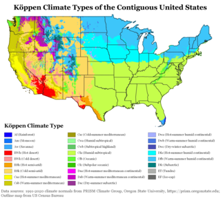
The climate of the United States varies due to changes in latitude, and a range of geographic features, including mountains and deserts. Generally, on the mainland, the climate of the U.S. becomes warmer the further south one travels, and drier the further west, until one reaches the West Coast.

Tropical Storm Dottie was the ninth tropical cyclone and fourth named storm of the 1976 Atlantic hurricane season. The precursor to Dottie formed in the Gulf of Mexico on August 17 and organized into a tropical depression on August 18. The storm drifted towards the east, and, after peaking as a moderate tropical storm, it accelerated northeastward and made landfall on Florida. Upon re-emerging in the Atlantic, Dottie turned northward and moved ashore near Charleston, South Carolina. Damage from the storm was primarily insignificant and limited to gusty winds, heavy rainfall, and high tides; however, a fishing boat capsized in the Bahamas, resulting in the deaths of four people.

The 1960 Texas tropical storm brought severe but localized flooding to southeastern Texas in June 1960. The first tropical cyclone and first tropical storm of the 1960 Atlantic hurricane season, this system developed from an area of showers and thunderstorms in the Bay of Campeche on June 22. Initially a tropical depression, it strengthened and was estimated to have reached tropical storm status on June 23. Early on the following day, the storm peaked with winds of 60 mph (95 km/h). Later that day, it made landfall near Corpus Christi, Texas, at the same intensity. The storm weakened slowly and moved across the Central United States, before dissipating over Illinois on June 28.

The 2020 Atlantic hurricane season was the most active Atlantic hurricane season on record, surpassing a record previously set in 2005. The season featured a total of 31 tropical or subtropical cyclones, all but one of which became a named storm. Of the 30 named storms, 14 developed into hurricanes, and a record-tying seven further intensified into major hurricanes. It was the second and final season to use the Greek letter storm naming system, the first being 2005. Of the 30 named storms, 11 of them made landfall in the contiguous United States, breaking the record of nine set in 1916. During the season, 27 tropical storms established a new record for earliest formation date by storm number. This season also featured a record 10 tropical cyclones that underwent rapid intensification, tying it with 1995. This unprecedented activity was fueled by a La Niña that developed in the summer months of 2020. Despite the record-high activity, this was the first season since 2015 in which no Category 5 hurricane formed. It did, however, continue a stretch of above-average seasonal activity that began in 2016.

Tropical Storm Andrea brought flooding to Cuba, the Yucatan Peninsula, and portions of the East Coast of the United States in June 2013. The first tropical cyclone and named storm of the annual hurricane season, Andrea originated from an area of low pressure in the eastern Gulf of Mexico on June 5. Despite strong wind shear and an abundance of dry air, the storm strengthened while initially heading north-northeastward. Later on June 5, it re-curved northeastward and approached the Big Bend region of Florida. Andrea intensified and peaked as a strong tropical storm with winds at 65 mph (100 km/h) on June 6. A few hours later, the storm weakened slightly and made landfall near Steinhatchee, Florida later that day. It began losing tropical characteristics while tracking across Florida and Georgia. Andrea transitioned into an extratropical cyclone over South Carolina on June 7, though the remnants continued to move along the East Coast of the United States, until being absorbed by another extratropical system offshore Maine on June 10.

Tropical Storm Bill was a tropical cyclone that produced widespread rainfall across East Texas, Oklahoma, the Midwest, and Mid-Atlantic. The second named storm of the season, Bill developed from a broad area of low pressure over the northwestern Gulf of Mexico on June 16. Because the system was already producing tropical storm force winds, it was immediately classified as Tropical Storm Bill. Initially continuing northwestward, Bill re-curved west-northwestward later on June 16. Around 12:00 UTC, the storm peaked with maximum sustained winds of 60 mph (95 km/h). Just under five hours later, Bill made landfall near on Matagorda Island, Texas, at the same intensity. The cyclone weakened to a tropical depression and turned northward early on June 17. Bill remained a tropical cyclone until late on June 18, when it degenerated into a remnant low. The remnant low moved east-northeastward until dissipating over West Virginia on June 21.

Tropical Storm Fernand was a short-lived tropical storm that caused severe flooding in northern Mexico in early September 2019. The sixth named storm of the 2019 Atlantic hurricane season, Fernand developed from a broad area of low pressure that was first monitored in the southeastern Gulf of Mexico on August 31. Gradual organization ensued as the low moved westward, and it developed into a tropical depression early on September 3. The cyclone quickly strengthened into Tropical Storm Fernand six hours after formation, and attained peak winds of 50 mph (85 km/h) early on September 4. However, easterly wind shear and the cyclone's close proximity to the Mexican coast prevented further development, and Fernand weakened slightly before making landfall along the coast of northeastern Mexico at 15:15 UTC September 4. Fernand quickly weakened to a tropical depression as it moved over the Sierra Madre Oriental, and by 03:00 UTC on September 5, the cyclone had dissipated over the rugged terrain of Mexico. Fernand caused torrential, much-needed rainfall in Monterrey and other communities.

Tropical Storm Imelda was the fourth-wettest tropical cyclone on record in the U.S. state of Texas, causing devastating and record-breaking floods in southeast Texas. The eleventh tropical cyclone and ninth named storm of the 2019 Atlantic hurricane season, Imelda formed out of an upper-level low that developed in the Gulf of Mexico and moved westward. Little development occurred until the system was near the Texas coastline, where it rapidly developed into a tropical storm before moving ashore shortly afterward on September 17. Imelda weakened after landfall, but continued bringing large amounts of flooding rain to Texas and Louisiana, before dissipating on September 21.

Tropical Storm Bertha was a rapidly forming and short-lived off-season tropical storm that affected the Eastern United States in late May 2020. The second named storm of the very active 2020 Atlantic hurricane season, Bertha originated from a trough in the Gulf of Mexico. The National Hurricane Center (NHC) only anticipated slight development as the trough moved over southern Florida, bringing torrential rainfall. The system rapidly organized on May 27 after it emerged into the western Atlantic Ocean, developing a small, well-defined circulation. That day, the disturbance developed into Tropical Storm Bertha east of Georgia, and a few hours later it moved ashore near Isle of Palms, South Carolina with peak winds of 50 mph (85 km/h). The storm weakened over land and dissipated late on May 28 over West Virginia.

Tropical Storm Claudette was a weak tropical cyclone that caused heavy rain and tornadoes across the Southeastern United States in June 2021, leading to severe damage. The third named storm of the 2021 Atlantic hurricane season, Claudette originated from a broad trough of low pressure over the Bay of Campeche on June 12. The disturbance moved erratically over the region for the next several days, before proceeding northward with little development due to unfavorable upper-level winds and land interaction. Despite this, the National Hurricane Center (NHC) initiated advisories on it as a Potential Tropical Cyclone late on June 17, due to its imminent threat to land. The disturbance finally organized into Tropical Storm Claudette at 00:00 UTC on June 19 just before landfall in southeast Louisiana. Claudette weakened to a depression as it turned east-northeastward before moving through Mississippi, Alabama, Georgia, and South Carolina. Baroclinic forcing then caused Claudette to reintensify into a tropical storm over North Carolina early on June 21 before it accelerated into the Atlantic Ocean later that day. Soon afterward, it degenerated into a low-pressure trough on the same day, before being absorbed into another extratropical cyclone on the next day.