
The Canary Islands, also known informally as the Canaries, is a Spanish archipelago in the Atlantic Ocean, in a region known as Macaronesia. At their closest point to the African mainland, they are 100 kilometres west of Morocco. They are the southernmost of the autonomous communities of Spain, and are located in the African Tectonic Plate. The archipelago is economically and politically European, and is part of the European Union.

The Isle of Man, also known as Mann, is an island nation and self-governing British Crown Dependency in the Irish Sea between Great Britain and Northern Ireland. The head of state, Queen Elizabeth II, holds the title Lord of Mann and is represented by a Lieutenant Governor. The United Kingdom is responsible for the isle's military defence.

Mauritius, officially the Republic of Mauritius, is an island nation in the Indian Ocean about 2,000 kilometres (1,200 mi) off the southeast coast of the African continent, east of Madagascar. It includes the main island, as well as Rodrigues, Agaléga and St. Brandon. The islands of Mauritius and Rodrigues, along with nearby Réunion, are part of the Mascarene Islands. The capital and largest city, Port Louis, is located in Mauritius, where most of the population is concentrated. The country spans 2,040 square kilometres (790 sq mi) and has an exclusive economic zone covering 2.3 million square kilometres.
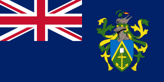
The Pitcairn Islands, officially the Pitcairn, Henderson, Ducie and Oeno Islands, also known as the British South Pacific Islands, is a group of four volcanic islands in the southern Pacific Ocean that form the sole British Overseas Territory in the Pacific Ocean. The four islands — Pitcairn, Henderson, Ducie, and Oeno — are scattered across several hundred kilometres of ocean and have a combined land area of about 18 square miles (47 km2). Henderson Island accounts for 86% of the land area, but only Pitcairn Island is inhabited. The islands nearest to the Pitcairn Islands are Mangareva to the west and Easter Island to the east.

Rhode Island, officially the State of Rhode Island, is a state in the New England region of the United States. It is the smallest U.S. state by area and the seventh-least populous, but it is also the second-most densely populated behind New Jersey. The state takes its name from Rhode Island; however, most of the state is on the mainland. The state has land borders with Connecticut to the west, Massachusetts to the north and east, and the Atlantic Ocean to the south via Rhode Island Sound and Block Island Sound. It also shares a small maritime border with New York. Providence is the state capital and most populous city in Rhode Island.

The Turks and Caicos Islands are a British Overseas Territory consisting of the larger Caicos Islands and smaller Turks Islands, two groups of tropical islands in the Lucayan Archipelago of the Atlantic Ocean and northern West Indies. They are known primarily for tourism and as an offshore financial centre. The resident population was 31,458 in 2012, of whom 23,769 lived on Providenciales in the Caicos Islands; July 2020 estimates put the population at 55,926. It is the third largest of the British overseas territories by population.

Andaman and Nicobar Islands is a union territory of India consisting of 572 islands, of which 38 are inhabited, at the junction of the Bay of Bengal and the Andaman Sea.

Saipan is the largest island of the Northern Mariana Islands, a commonwealth of the United States in the western Pacific Ocean. According to 2017 estimates by the United States Census Bureau and the Commonwealth's Department of Commerce, Saipan's population was 47,565.
Carolinian is an Austronesian language originating in the Caroline Islands, but spoken in the Northern Mariana Islands. It is an official language of the Carolinian people. Carolinian is a threatened language according to the Catalogue of Endangered Languages (ELCat), but available data is scarce. There are approximately 3,100 native speakers in the world. Carolinian has 95% lexical similarity with Satawalese, 88% with Woleaian and Puluwatese; 81% with Mortlockese; 78% with Chuukese, 74% with Ulithian.

The Roman Catholic Diocese of Chalan Kanoa is an ecclesiastical territory or diocese of the Catholic Church in the United States. It comprises the territory of the Commonwealth of the Northern Mariana Islands and is a suffragan of the Metropolitan Archdiocese of Agaña. The diocese was canonically erected on 8 November 1984 by Pope John Paul II. Its territories were taken from the archdiocese based in Guam.
Education in the Northern Mariana Islands is linked to the United States Department of Education as the Northern Mariana Islands form part of the United States Commonwealth. This encompasses the sectors of pre-K, elementary schools, middle schools, high schools and college education. The main governing body in the region is the Commonwealth of the Northern Mariana Islands Public School System whose headquarters are located in Susupe, Saipan. Currently, there are 20 schools operating within the CNMI PSS. There are also a number of private and home school systems operating in the region. The educational system follows a similar model to the United States educational system whereby children between the ages of 6-16 are mandated to attend formal school. All educational institutions, systems and budget are governed first by the US Board of Education, followed by the Northern Mariana Islands State Board of Education, which was established in 1988 as a requirement of the Northern Mariana Islands Constitution.

The Faroe Islands, or simply the Faroes or Faeroes, are a North Atlantic archipelago located 320 kilometres (200 mi) north-northwest of Scotland, and about halfway between Norway and Iceland. Like Greenland, it is a constituent country of the Kingdom of Denmark. The islands have a total area of about 1,400 square kilometres (540 sq mi) with a population of 52,703 as of September 2020.
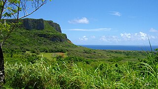
Laolao Bay is a large bay on the southeast side of Saipan in the Northern Mariana Islands.

Kagman High School (KHS) is one of three public high schools on Saipan, Northern Mariana Islands. It is located in Kagman, is part of the Commonwealth of the Northern Mariana Islands Public School System and opened in January 2002. KHS serves about 645 students from the villages of Kagman, north to Capitol Hill, and all the way through to Marpi.
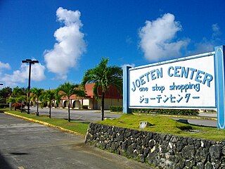
Joeten Enterprises, Inc. is a family-owned conglomerate in the Northern Marianas Islands that encompasses grocery stores, shipping services, automotive dealership, real estate, construction, and other businesses.
The Marianas tropical dry forests is a tropical and subtropical dry broadleaf forests ecoregion on the Marianas Islands in the western Pacific Ocean.
