
A stratovolcano, also known as a composite volcano, is a conical volcano built up by many layers (strata) of hardened lava and tephra. Unlike shield volcanoes, stratovolcanoes are characterized by a steep profile with a summit crater and periodic intervals of explosive eruptions and effusive eruptions, although some have collapsed summit craters called calderas. The lava flowing from stratovolcanoes typically cools and solidifies before spreading far, due to high viscosity. The magma forming this lava is often felsic, having high to intermediate levels of silica, with lesser amounts of less viscous mafic magma. Extensive felsic lava flows are uncommon, but have traveled as far as 15 km (9 mi).

Egmont National Park is located south of New Plymouth, close to the west coast of the North Island of New Zealand. The park covers three volcanic cones: Mount Taranaki and its slopes, Pouakai and Kaitake. The park was first created in 1881 as a forest reserve and went on to become New Zealand’s second national park, preceded by Tongariro National Park, in 1900.

Mount Taranaki is a dormant stratovolcano in the Taranaki region on the west coast of New Zealand's North Island. At 2,518 metres (8,261 ft), it is the second highest mountain in the North Island, after Mount Ruapehu. It has a secondary cone, Fanthams Peak, 1,966 metres (6,450 ft), on its south side.
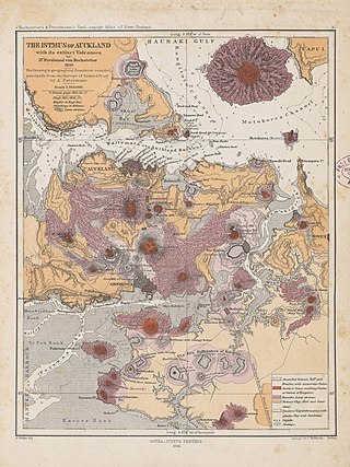
The Auckland volcanic field is an area of monogenetic volcanoes covered by much of the metropolitan area of Auckland, New Zealand's largest city, located in the North Island. The approximately 53 volcanoes in the field have produced a diverse array of maars, tuff rings, scoria cones, and lava flows. With the exception of Rangitoto, no volcano has erupted more than once, but the other eruptions lasted for various periods ranging from a few weeks to several years. Rangitoto erupted several times and recently twice; in an eruption that occurred about 600 years ago, followed by a second eruption approximately 50 years later. The field is fuelled entirely by basaltic magma, unlike the explosive subduction-driven volcanism in the central North Island, such as at Mount Ruapehu and Lake Taupō.

An active volcano is a volcano that has erupted during the Holocene, is currently erupting, or has the potential to erupt in the future. A volcano that is not currently erupting but could erupt in the future is known as a dormant volcano. Volcanoes that will not erupt again are known as extinct volcanoes.

Maungatautari is a mountain near Cambridge in the Waikato region in New Zealand's central North Island. The 797 metre high mountain is an extinct stratovolcano. It is a prominent peak and is visible across the Waipa District. The mountain is the site of Sanctuary Mountain Maungatautari a large ecological sanctuary and restoration project.

The volcanism of New Zealand has been responsible for many of the country's geographical features, especially in the North Island and the country's outlying islands.

The Sugar Loaf Islands are a collection of five small uninhabited islands and several sea stacks near Port Taranaki, New Zealand.

The Auckland Region of New Zealand is built on a basement of greywacke rocks that form many of the islands in the Hauraki Gulf, the Hunua Ranges, and land south of Port Waikato. The Waitākere Ranges in the west are the remains of a large andesitic volcano, and Great Barrier Island was formed by the northern end of the Coromandel Volcanic Zone. The Auckland isthmus and North Shore are composed of Waitemata sandstone and mudstone, and portions of the Northland Allochthon extend as far south as Albany. Little Barrier Island was formed by a relatively isolated andesitic volcano, active around 1 to 3 million years ago.
The Waikato and King Country regions of New Zealand are built upon a basement of greywacke rocks, which form many of the hills. Much of the land to the west of the Waikato River and in the King Country to the south has been covered by limestone and sandstone, forming bluffs and a karst landscape. The volcanic cones of Karioi and Pirongia dominate the landscape near Raglan and Kawhia Harbours. To the east, the land has been covered with ignimbrite deposits from the Taupō Volcanic Zone. Large amounts of pumice from the Taupō Volcanic Zone have been deposited in the Waikato Basin and Hauraki Plains.
The Taranaki Region of New Zealand is built upon the Median Batholith in the West, and Greywacke Rocks in the East. However, no rocks older than Miocene times are visible at the surface. The dominant feature of the Taranaki Region is the andesitic stratovolcano of Mount Taranaki, which is only about 130,000 years old. The dissected hill country to the East of the Taranaki Peninsula, and West of the Central Volcanic Plateau is composed of soft Miocene to Pleistocene sandstone and mudstone. The coastal lowlands around Wanganui to the South have well-developed Quaternary marine terraces, and coastal sand dunes.

The Dunedin Volcano is an extensively eroded multi-vent shield volcano that was active between 16 and 10 million years ago. It originally extended from the modern city of Dunedin, New Zealand to Aramoana about 25 km away. Extensive erosion has occurred over the last 10 million years and Otago Harbour now fills the oldest parts of the volcano. The remnants of the volcano form the hills around Otago Harbour.

The Banks Peninsula Volcano is an extinct volcanic complex to the east of Christchurch on New Zealand's South Island. While the volcano is highly eroded it still forms the majority of Banks Peninsula with a highest point of 919 m (3,015 ft). It is a composite of two main eruptive centres one originating at Lyttelton Harbour, the other at Akaroa Harbour. The eruptions were predominantly basaltic, with associated andesite and trachytes, with minor rhyolite. The volcanic activity occurred in the Late Miocene and possibly extended into the Early Pliocene. There are four volcanic groups, all of which are within the Māui Supergroup. The Christchurch earthquakes led to rumors of a possible eruption, however, there is no known magma chamber beneath the volcano and there has not been any sign of volcanic activity in the last 5 million years.

The Pouakai Range is an eroded and heavily vegetated stratovolcano in the North Island of New Zealand, located northwest of Mount Taranaki. It consists of the remains of a collapsed Pleistocene stratovolcano. The range is surrounded by a ring plain of lahar deposits from a massive collapse that has been dated as roughly 250,000 years old.
The Waitākere volcano, also known as the Manukau volcano, was a Miocene era volcano that formed off the west coast of the modern Auckland Region of New Zealand's North Island. Erupting intermittently between 23 million and 15 million years ago, the volcano was at one point one of the tallest mountains in New Zealand. The volcano alternated between periods as a seamount and as a volcanic island, before tectonic forces raised the volcano up from the seafloor 17 million years ago. Volcanism at the site ceased 15 million years ago and the cone has mostly eroded, however the modern Waitākere Ranges are formed from the remnants of the volcano's eastern slopes. A number of visible volcanic sites associated with the Waitākere volcano remain around Auckland, including Pukematekeo, Karekare and Lion Rock.

The South Auckland volcanic field, also known as the Franklin Volcanic Field, is an area of extinct monogenetic volcanoes around Pukekohe, the Franklin area and north-western Waikato, south of the Auckland volcanic field. The field contains at least 82 volcanoes, which erupted between 550,000 and 1,600,000 years ago.
The Alexandra Volcanic Group is a chain of extinct calc-alkalic basaltic stratovolcanoes that were most active between 2.74 and 1.60 million years ago but is now known to have had more recent activity between 1.6 and 0.9 million years ago. They extend inland from Mount Karioi near Raglan with Mount Pirongia being the largest, with Pukehoua on the eastern slopes of Pirongia, Kakepuku, Te Kawa, and Tokanui completing the definitive lineament. The associated, but usually separated geologically basaltic monogenetic Okete volcanic field, lies mainly between Karioi and Pirongia but extends to the east and is quite scattered.
The Tauranga Volcanic Centre is a geologic region in New Zealand's Bay of Plenty. It extends from the southern end of Waihi Beach and from the old volcanoes of the Coromandel Peninsula that make up the northern part of the Kaimai Range, towards the Taupō Volcanic Zone.
Much of the volcanic activity in the northern portions of the North Island of New Zealand is recent in geological terms and has taken place over the last 30 million years. This is primarily due to the North Island's position on the boundary between the Indo-Australian and Pacific Plates, a part of the Pacific Ring of Fire, and particularly the subduction of the Pacific Plate under the Indo-Australian Plate. The activity has included some of the world's largest eruptions in geologically recent times and has resulted in much of the surface formations of the North Island being volcanic as shown in the map.
The volcanic activity in the South Island of New Zealand terminated 5 million years ago as the more northern parts of the North Island became extremely volcanically active. The South Islands surface geology reflects the uplift of the Pacific Plate as it collides with the Indo-Australian Plate along the Alpine Fault over the last 12 million years and the termination of subduction, about 100 to 105 million years ago. There is a very small chance of reactivation of volcanism in the Dunedin Volcano. This chance is made slightly higher by the observation that Southland's Solander Islands / Hautere just off the coast of the South Island were active as recently as 50,000 years old, and on a larger scale 150,000 years old.
