Early history
The earliest history of Kakongo is unknown, and oral traditions collected in the region in the 19th and 20th centuries do not do much to elucidate. [1] In its present state, archaeology can only attest that the region was already in the Iron Age by the 5th century BC, and that complex societies were emerging in the general vicinity by the early centuries CE.
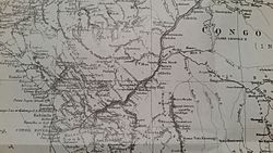
The kingdom is first mentioned in the titles of the King of Kongo Afonso I in 1535, in which he notes that he was king over this region, as well as a number of others located along the north bank of the Congo River. [2] This title has led historians to believe that Kakongo was once part of a federation of states that included Kongo and that may have formed around the late 14th century. Kakongo was, however, an independent state for all intents and purposes from the 16th century onward. Portuguese merchants, interested in the trade in copper, ivory, and slaves, began to establish factories in Kakongo in the 1620s, and Dutch and English merchants also visited the kingdom during the 17th century. Its capital was called Kinguele and was an inland town.
Commercial center
Kakongo became a very important commercial center in the 18th century, regularly visited by ships from England, France, the Netherlands, and Portugal. Its port of Cabinda was a major hub that lay in a protected bay. Slaves dominated the exports of the country, though most were simply transhipped from areas further south, mostly from the Kingdom of Kongo and the eastern provinces of Angola, such as Matamba.
Important goods that were also traded included gunpowder, guns, knives, cotton cloths, glass beads, copper and iron bars. In 1775, French missionaries sought to convert the kingdom, along with its neighbors, to Christianity, hoping to reap the fruit of its long association with the neighboring, Christian, Kingdom of Kongo. The mission was largely unsuccessful but did make contact with a community of Christians from Kongo's province of Soyo, living in the town of Manguenzo in the interior. The mission was ultimately abandoned.
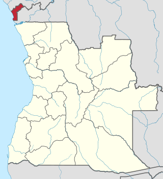
Cabinda is an exclave and province of Angola in Africa, a status that has been disputed by several political organizations in the territory. The capital city is also called Cabinda, known locally as Tchiowa, Tsiowa or Kiowa. The province is divided into four municipalities—Belize, Buco-Zau, Cabinda and Cacongo.
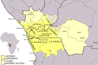
Kongo or Kikongo is one of the Bantu languages spoken by the Kongo people living in the Democratic Republic of the Congo, the Republic of the Congo, Gabon and Angola. It is a tonal language. It was spoken by many of those who were taken from the region and sold as slaves in the Americas. For this reason, while Kongo still is spoken in the above-mentioned countries, creolized forms of the language are found in ritual speech of Afro-American religions, especially in Brazil, Cuba, Puerto Rico, the Dominican Republic and Haiti. It is also one of the sources of the Gullah language and the Palenquero creole in Colombia. The vast majority of present-day speakers live in Africa. There are roughly seven million native speakers of Kongo, with perhaps two million more who use it as a second language.

Central Africa is a subregion of the African continent comprising various countries according to different definitions. Middle Africa is an analogous term used by the United Nations in its geoscheme for Africa and consists of the following countries: Angola, Burundi, Cameroon, Central African Republic, Chad, Democratic Republic of the Congo, Republic of the Congo, Equatorial Guinea, Gabon, Rwanda, and São Tomé and Príncipe. These eleven countries are members of the Economic Community of Central African States (ECCAS). Six of those countries are also members of the Economic and Monetary Community of Central Africa (CEMAC) and share a common currency, the Central African CFA franc.
The Kongo people are a Bantu ethnic group primarily defined as the speakers of Kikongo. Subgroups include the Beembe, Bwende, Vili, Sundi, Yombe, Dondo, Lari, and others.
The pre-colonial history of the modern-day Democratic Republic of the Congo encompasses the history of the Congo Basin region up to the establishment of European colonial rule in the era of New Imperialism and particularly the creation of the Congo Free State and its expansion into the interior after 1885. As the modern territorial boundaries of the Democratic Republic of the Congo did not exist in this period, it is inseparable from the wider pre-colonial histories of Central Africa, the Great Lakes and Rift Valley as well as the Atlantic World and Swahili coast.

The Kingdom of Loango was a pre-colonial African state, during approximately the 16th to 19th centuries in what is now the western part of the Republic of the Congo, Southern Gabon and Cabinda. Situated to the north of the more powerful Kingdom of Kongo, at its height in the 17th century Loango influence extended from Cape St Catherine in the north to almost the mouth of the Congo River.

Ngoyo was an Iron Age kingdom state of the Woyo ethnic group, located in the south of Cabinda. Located on the Atlantic coast of Central Africa, just north of the Congo River, it was founded by Bantu-speaking people around the 15th century. Ngoyo tradition held that the kingdom's ancestors were among the earliest settlers in the area, leading their chiefs to title themselves the nfumu nsi. The capital was Mbanza Ngoyo. By 1700, Cabinda had become the leading slave port north of Luanda, and Ngoyo's economy rested heavily on the sale of slaves.
The Kingdom of Kongo was a kingdom in Central Africa. It was located in present-day northern Angola, the western portion of the Democratic Republic of the Congo, and the Republic of the Congo. At its greatest extent it reached from the Atlantic Ocean in the west to the Kwango River in the east, and from the Congo River in the north to the Kwanza River in the south. The kingdom consisted of several core provinces ruled by the Manikongo, the Portuguese version of the Kongo title Mwene Kongo, meaning "lord or ruler of the Kongo kingdom", but its sphere of influence extended to neighboring kingdoms, such as Ngoyo, Kakongo, Loango, Ndongo, and Matamba, the latter two located in what is Angola today.
Soyo is a city, with a population of 200,920, and a municipality, with a population of 227,175, located in the province of Zaire in Angola, at the mouth of the Congo river. Soyo recently became the largest oil-producing region in the country, with an estimate of 1,200,000 barrels per day (190,000 m3/d).
The precolonial history of Angola lasted until Portugal annexed the territory as a colony in 1655.
The colonial history of Angola is usually considered to run from the appearance of the Portuguese under Diogo Cão in 1482 (Congo) or 1484 until the independence of Angola in November 1975. Settlement did not begin until Novais's establishment of São Paulo de Loanda (Luanda) in 1575, however, and the Portuguese government only formally incorporated Angola as a colony in 1655 or on May 12, 1886.

Loango-Angola is the name for the possessions of the Dutch West India Company in contemporary Angola and the Republic of the Congo. Notably, the name refers to the colony that was captured from the Portuguese between 1641 and 1648. Due to the distance between Luanda and Elmina, the capital of the Dutch Gold Coast, a separate administration for the southern districts of Africa was established at Luanda during the period of the Dutch occupation.
The Kingdom of Orungu was a small, pre-colonial state of what is now Gabon in Central Africa. Through its control of the slave trade in the 18th and 19th centuries, it was able to become the most powerful of the trading centers that developed in Gabon during that period.
Cacongo is a municipality in Cabinda Province, an exclave of Angola. Its principal town is Cacongo. Landana lies on the coast of the Atlantic Ocean, adjacent to Landana Bay. The municipality covers 1,679 square kilometres (648 sq mi) and had a population of 39,076 at the 2014 Census; the latest official estimate is 44,974.
Cacongo is a town, with a population of 15,000 (2014), in Cacongo municipality, Cabinda Province, in Angola. The former Lândana municipality is now known as Cacongo, and the town is sometimes still known as Lândana. It is located on Lândana Bay about a kilometer south of the mouth of the Chiloango River.

Portuguese Angola refers to Angola during the historic period when it was a territory under Portuguese rule in southwestern Africa. In the same context, it was known until 1951 as Portuguese West Africa.
Vili (Civili) is one of the Zone H Bantu languages, grouped with the Kongo clade.

Loango Slavery Harbour is a Republic of the Congo cultural site included in World Heritage Tentative Lists in 2008–09.
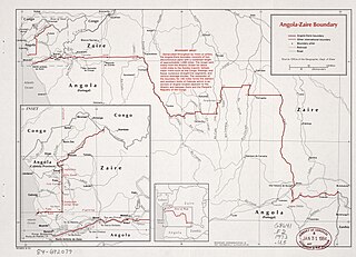
The Angola–Democratic Republic of the Congo border is 2,646 km in length and consists of two non-contiguous sections: a 225 km section along the border with Angola's province of Cabinda, running from the Atlantic Ocean to the tripoint with the Republic of Congo, and a much longer 2,421 km section running from the Atlantic to the tripoint with Zambia.

Marcellino d'Atri was a Capuchin missionary from Atri in the Kingdom of Naples who spent several years in the Kingdom of Kongo. His memoirs give much valuable information about the region around the end of the 17th century, although they betray the typical prejudices about Africans of a European at the time.