Africa is a continent comprising 63 political territories, representing the largest of the great southward projections from the main mass of Earth's surface. Within its regular outline, it comprises an area of 30,368,609 km2 (11,725,385 sq mi), excluding adjacent islands. Its highest mountain is Mount Kilimanjaro; its largest lake is Lake Victoria.

The Nile is a major north-flowing river in northeastern Africa. It flows into the Mediterranean Sea. The Nile is the longest river in Africa and has historically been considered the longest river in the world, though this has been contested by research suggesting that the Amazon River is slightly longer. Of the world's major rivers, the Nile is one of the smallest, as measured by annual flow in cubic metres of water. About 6,650 km (4,130 mi) long, its drainage basin covers eleven countries: the Democratic Republic of the Congo, Tanzania, Burundi, Rwanda, Uganda, Kenya, Ethiopia, Eritrea, South Sudan, Republic of the Sudan, and Egypt. In particular, the Nile is the primary water source of Egypt, Sudan and South Sudan. Additionally, the Nile is an important economic river, supporting agriculture and fishing.

Tanzania comprises many lakes, national parks, and Africa's highest point, Mount Kilimanjaro. Northeast Tanzania is mountainous, while the central area is part of a large plateau covered in grasslands. The country also contains the southern portion of Lake Victoria on its northern border with Uganda and Kenya.

The Congo River, formerly also known as the Zaire River, is the second-longest river in Africa, shorter only than the Nile, as well as the third largest river in the world by discharge volume, following the Amazon and the Ganges rivers. It is also the world's deepest recorded river, with measured depths of around 220 m (720 ft). The Congo-Lualaba-Chambeshi River system has an overall length of 4,700 km (2,900 mi), which makes it the world's ninth-longest river. The Chambeshi is a tributary of the Lualaba River, and Lualaba is the name of the Congo River upstream of Boyoma Falls, extending for 1,800 km (1,100 mi).

The Zambezi is the fourth-longest river in Africa, the longest east-flowing river in Africa and the largest flowing into the Indian Ocean from Africa. Its drainage basin covers 1,390,000 km2 (540,000 sq mi), slightly less than half of the Nile's. The 2,574-kilometre-long (1,599 mi) river rises in Zambia and flows through eastern Angola, along the north-eastern border of Namibia and the northern border of Botswana, then along the border between Zambia and Zimbabwe to Mozambique, where it crosses the country to empty into the Indian Ocean.

Yoho National Park is a national park of Canada. It is located within the Rocky Mountains along the western slope of the Continental Divide of the Americas in southeastern British Columbia, bordered by Kootenay National Park to the south and Banff National Park to the east in Alberta. The word Yoho is a Cree expression of amazement or awe, and it is an apt description for the park's spectacular landscape of massive ice fields and mountain peaks, which rank among the highest in the Canadian Rockies.

The Iranian plateau or Persian plateau is a geological feature spanning parts of West Asia, Central Asia, and South Asia. It makes up part of the Eurasian Plate, and is wedged between the Arabian Plate and the Indian Plate. The plateau is situated between the Zagros Mountains to the west, the Caspian Sea and the Köpet Dag to the north, the Armenian Highlands and the Caucasus Mountains to the northwest, the Strait of Hormuz and the Persian Gulf to the south, and the Indian subcontinent to the east.

Ujiji is the oldest town in western Tanzania and is located in Kigoma-Ujiji District of Kigoma Region. Originally a Swahili settlement and then an Arab slave trading post by the mid-nineteenth century nominally under the Sultanate of Zanzibar, the town is the oldest in western Tanzania. In 1900, the population was estimated at 10,000 and in 1967 about 41,000. The site is a registered National Historic Site.
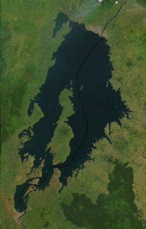
Lake Kivu is one of the African Great Lakes. It lies on the border between the Democratic Republic of the Congo and Rwanda, and is in the Albertine Rift, the western branch of the East African Rift. Lake Kivu empties into the Ruzizi River, which flows southwards into Lake Tanganyika.

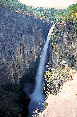
The Kalambo Falls on the Kalambo River is a 235-metre (772 ft) single-drop waterfall on the border of Zambia and Rukwa Region, Tanzania at the southeast end of Lake Tanganyika. The falls are some of the tallest uninterrupted falls in Africa. Downstream of the falls is the Kalambo Gorge, which has a width of about 1 km and a depth of up to 300 m, running for about 5 km before opening out into the Lake Tanganyika rift valley. The Kalambo waterfall is the tallest waterfall in both Tanzania and Zambia. The expedition which mapped the falls and the area around it was in 1928 and led by Enid Gordon-Gallien. Initially it was assumed that the height of falls exceeded 300 m, but measurements in the 1920s gave a more modest result, above 200 m. Later measurements, in 1956, gave a result of 221 m. After this several more measurements have been made, each with slightly different results. The width of the falls is 3.6–18 m.
Mbala is Zambia’s most northerly large town and seat of Mbala District in Northern Province, occupying a strategic location close to the border with Tanzania and controlling the southern approaches to Lake Tanganyika, 40 km by road to the north-west, where the port of Mpulungu is located. It had a population of about 20,000 in 2006. Under the name Abercorn, Mbala was a key outpost in British colonial control of this part of south-central Africa.

The Sivalik Hills, also known as the Shivalik Hills and Churia Hills, are a mountain range of the outer Himalayas that stretches over about 2,400 km (1,500 mi) from the Indus River eastwards close to the Brahmaputra River, spanning the northern parts of the Indian subcontinent. It is 10–50 km (6.2–31.1 mi) wide with an average elevation of 1,500–2,000 m (4,900–6,600 ft). Between the Teesta and Raidāk Rivers in Assam is a gap of about 90 km (56 mi). The literal translation of "Sivalik" is 'tresses of Shiva'. Sivalik region is home to the Soanian archaeological culture. The hills are well known for their Neogene and Pleistocene aged vertebrate fossils.

The Ruzizi is a river, 117 kilometres (73 mi) long, that flows from Lake Kivu to Lake Tanganyika in Central Africa, descending from about 1,500 metres (4,900 ft) to about 770 metres (2,530 ft) above sea level over its length. The steepest gradients occur over the first 40 kilometres (25 mi), where hydroelectric dams have been built. Further downstream, the Ruzizi Plain, the floor of the Western Rift Valley, has gentle hills, and the river flows into Lake Tanganyika through a delta, with one or two small channels splitting off from the main channel.

Lake Rukwa is an endorheic lake located the Rukwa Valley of Rukwa Region, Songwe Region and Katavi Region in southwestern Tanzania. The lake is the third largest inland body of water in the country.

The Lukuga River is a tributary of the Lualaba River in the Democratic Republic of the Congo (DRC) that drains Lake Tanganyika. It is unusual in that its flow varies not just seasonally but also due to longer term climate fluctuations.

Rukwa Region(Mkoa wa Rukwa in Swahili) is one of Tanzania's 31 administrative regions The region covers a land area of 27,765 km2 (10,720 sq mi). The region is comparable in size to the combined land area of the nation state of Haiti. Rukwa Region is bordered to the north by Katavi Region, to the east by Songwe Region, to the south by the nation of Zambia and to the west by Lake Tanganyika, which forms a border between Tanzania and the Democratic Republic of the Congo. The regional capital is the municipality of Sumbawanga. According to the 2012 national census, the region had a population of 1,004,539.

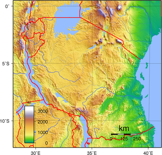
The Albertine Rift is the western branch of the East African Rift, covering parts of Uganda, the Democratic Republic of the Congo (DRC), Rwanda, Burundi and Tanzania. It extends from the northern end of Lake Albert to the southern end of Lake Tanganyika. The geographical term includes the valley and the surrounding mountains.
This article gives lists of the National Monuments and other historic sites of Zambia, with a one- or two-line description providing links to details given on other pages.
Mainland Tanzania refers to the part of Tanzania on the continent of Africa; excluding the islands of Zanzibar. It corresponds with the area of the former country of Tanganyika.
The Ufipa Plateau is a highland in southwestern Tanzania. It lies mostly in Rukwa Region, near the border with Zambia. The plateau is named for the Fipa people who inhabit it.