Årdalstangen is the administrative centre of the municipality Årdal in Sogn og Fjordane county, Norway. The village is one of the two main population centers in the municipality, along with the village of Øvre Årdal. The 1.08-square-kilometre (270-acre) village has a population (2013) of 1,489; giving the village a population density of 1,379 inhabitants per square kilometre (3,570/sq mi).
Måløy is a town and the administrative centre of the municipality of Vågsøy in Sogn og Fjordane county, Norway. Måløy is located on the southeastern side of the island of Vågsøy, about 3 kilometres (1.9 mi) northeast of the village of Holvika and about 6 kilometres (3.7 mi) south of the village of Raudeberg. The Måløy Bridge connects the town centre to the area of Deknepollen on the mainland. Sør-Vågsøy Church is located in Måløy.

Fimreite is a small village in the municipality of Sogndal in Sogn og Fjordane county, Norway. The village sits on the south side of the mouth of the Sogndalsfjorden, where it empties into the main Sognefjorden. It is located near the end of a peninsula about 22 kilometres (14 mi) southwest of the village of Sogndalsfjøra and about 18 kilometres (11 mi) southwest of the village of Kaupanger. The village of Nornes lies across the Sogndalsfjorden from Fimreite.
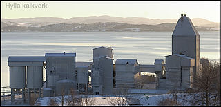
Hylla is a village in the municipality of Inderøy in Trøndelag county, Norway. Hylla is located along the Trondheimsfjord, about 2 kilometres (1.2 mi) south of the village of Røra and about 8 kilometres (5.0 mi) east of the villages of Straumen and Sakshaug. The village is home to a large limestone quarry and processing facility.

Raudsand or Rausand is a village in Nesset Municipality in Møre og Romsdal county, Norway. It is located on the Romsdal peninsula along the Tingvollfjorden about 9 kilometres (5.6 mi) northeast of the village of Eidsvåg and 8 kilometres (5.0 mi) south of the village of Angvika in Gjemnes Municipality. The 0.45-square-kilometre (110-acre) village has a population (2013) of 277, which gives the village a population density of 616 inhabitants per square kilometre (1,600/sq mi).
Fiskåbygd or Fiskå is a coastal village that is also the administrative centre of Vanylven Municipality in Møre og Romsdal county, Norway. The village is located about 100 kilometres (62 mi) southwest of the city of Ålesund, about 12 kilometres (7.5 mi) east of the village of Myklebost, and about 30 kilometres (19 mi) southwest of the village of Rovdane. Fiskåbygd lies along the shores of the Vanylvsfjorden, east of the Stadlandet peninsula in Selje Municipality.
Grøa is a village in Sunndal Municipality in Møre og Romsdal county, Norway. The village is located along the river Driva and along the Norwegian National Road 70, about 8.5 kilometres (5.3 mi) east of Sunndalsøra and about 5 kilometres (3.1 mi) east of Hoelsand. The Vinnufossen waterfall lies about 3 kilometres (1.9 mi) west of the village.

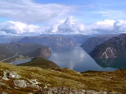
Lærdalsøyri is the administrative centre of the municipality of Lærdal in Sogn og Fjordane county, Norway. The village is located along the Lærdalselvi river where it empties into the Lærdalsfjorden, a branch off of the main Sognefjorden. The village is located about 4 kilometres (2.5 mi) north of the village of Tønjum at the east end of the Lærdal Tunnel which is part of the European route E16 highway. It sits about 25 kilometres (16 mi) northwest of the village of Borgund and about 15 kilometres (9.3 mi) across the fjord from the village of Kaupanger in Sogndal Municipality. The 1.03-square-kilometre (250-acre) village has a population (2013) of 1,120; giving the village a population density of 1,087 inhabitants per square kilometre (2,820/sq mi). Hauge Church is located in the village, and serves as the main church for the parish.

Kjørnes is a small village area in the municipality of Sogndal in Sogn og Fjordane county, Norway. It is located at the inner part of the Sogndalsfjorden, about 3.5 kilometres (2.2 mi) southeast of the municipal center of Sogndalsfjøra and about 6.5 kilometres (4.0 mi) northwest of the village of Kaupanger. Kjørnes is a suburb or bedroom community for the village of Sogndalsfjøra. The village area sits along Norwegian National Road 5 on the steep, forested, hill leading down to the shore of the fjord.

Sogndalsfjøra is the administrative center of the municipality of Sogndal in Sogn og Fjordane county, Norway. It is located where the river Sogndalselvi runs out in the Sogndalsfjorden, a branch of the large Sognefjorden. The village is located about 3.5 kilometres (2.2 mi) northwest of the village of Kjørnes, about 10 kilometres (6.2 mi) northwest of the village of Kaupanger, and about 31 kilometres (19 mi) southeast of the village of Fjærland.

Raudeberg is a village in Vågsøy Municipality in Sogn og Fjordane county, Norway. It is located on the east side of the island of Vågsøy. The villages of Refvika, Vedvika, and Langeneset are located a few kilometers to the north, and the town of Måløy is about 6 kilometres (3.7 mi) to the south. The island of Silda is located about 2 kilometres (1.2 mi) northeast of the village of Raudeberg. Nord-Vågsøy Church is located on the eastern edge of the village, right along the coast.
Glærem is a village in Surnadal Municipality in Møre og Romsdal county, Norway. The village is located along the north shore of the Surnadalsfjorden, about 3 kilometres (1.9 mi) northwest of Sylte and about 5 kilometres (3.1 mi) northwest of Skei and Surnadalsøra. The 0.59-square-kilometre (150-acre) village has a population (2013) of 261.

Vågsvåg is a village in Vågsøy Municipality in Sogn og Fjordane county, Norway. It is located on the southern shore of the island of Vågsøy along the Vågsfjorden, a part of the main Nordfjorden. The village looks across the fjord towards the island of Husevågøy.
Bryggja is a village in eastern part of Vågsøy Municipality in Sogn og Fjordane county, Norway. It is located on the mainland, along the northern shore of the Nordfjorden. The village is located about 15 kilometres (9.3 mi) east of the urban area of Måløy–Deknepollen–Tennebø in Vågsøy and it is about 25 kilometres (16 mi) west of Stårheim in neighboring Eid municipality. The small village of Totland lies just west of Bryggja.

Sogndalsstranda or Sogndalstrand is a harbor village in Sokndal municipality in Rogaland county, Norway. The village is located at the mouth of the river Sokno, about 2 kilometres (1.2 mi) south of the municipal centre of Hauge and also about 2 kilometres (1.2 mi) southeast of the village of Rekefjord. The Jøssingfjorden lies about 2.7 kilometres (1.7 mi) southeast of the village.
Tornes is a village in Fræna Municipality in Møre og Romsdal county, Norway. The village is located along the Julsundet strait at the mouth of the Frænfjorden. It is about 5 kilometres (3.1 mi) west of the municipal center of Elnesvågen and about 12 kilometres (7.5 mi) south of the village of Bud. The 0.38-square-kilometre (94-acre) village has a population (2013) of 512, which gives the village a population density of 1,347 inhabitants per square kilometre (3,490/sq mi).

Skei is a village and the administrative center of Surnadal Municipality in Møre og Romsdal county, Norway. The village is located at near the end of the Surnadalsfjorden along the river Surna. It is about 1 kilometre (0.62 mi) northeast of the village of Surnadalsøra and about 2 kilometres (1.2 mi) southeast of the village of Sylte. There are two churches near Skei: Øye Church and Ranes Church.
Årset is a village in Ålesund Municipality in Møre og Romsdal county, Norway. The village is located along the Ellingsøyfjorden on the southern shore of the island of Ellingsøya, about 4 kilometres (2.5 mi) east of the village of Myklebost and about 12 kilometres (7.5 mi) west of the village of Tennfjord in Haram Municipality.
Not to be confused with Leikanger, a municipality along the Sognefjord in the same county.