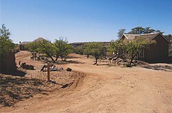
History
A freak accident that killed a mining engineer allowed Kentucky Camp to persist as it is today, a scenic canyon dotted with mesquites, oaks, tall grasses and cacti. The plans for the Kentucky Camp area in the realm of gold mining were ambitious but never really came to fruition.
Early days
In 1874 gold was discovered on the eastern slope of the Santa Rita Mountains. The area became known as the Greaterville mining district and proved to be one of the richest placer deposits in southern Arizona. Placer deposits consist of a mixture of gold, sand and gravel; to separate the substances, water is required. Generally, water is readily available to wash the mixture of sand, gravel, and gold. However, the arroyos of the Santa Rita Mountains are dry. Miners were required to haul the sacks of dirt to the few running streams in the area. Sometimes they would carry packed water, in canvas and goatskin bags, on the backs of burros to their claims. By 1886, much of the rich deposits that were worth such an effort were worked out and many miners gave up and moved on. [3]
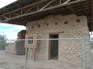
In 1902 a California mining engineer, James Stetson, had an idea to solve the water problem. His scheme involved channeling seasonal runoff from the mountain streams into a reservoir that would hold enough water to last ten months allowing him to keep a mine in operation. Stetson was able to convince a wealthy Californian, George McAneny (not to be confused with New Yorker George McAneny), to invest in his plan and with other investors from Tucson they formed the Santa Rita Water and Mining Company. The pair prospected the area of Greaterville and finally settled on a mining site in Boston Gulch. The headquarters was set up at nearby Kentucky Gulch and from 1902 until 1906, the buildings at Kentucky Camp served as the offices and residences for the mine employees. [3]
By mid-1904, the company's water system was complete and they were doing hydraulic mining at Kentucky Camp.
The fall of a camp and engineer
One day before a meeting with stockholders in 1905 tragedy befell Stetson. He was killed in a fall from a window at the Santa Rita Hotel in Tucson. His partner's finances and health deteriorated and despite the effort of the other partners to keep the operation going, Kentucky Camp was abandoned by 1912. [3]
The town after 1912
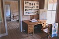
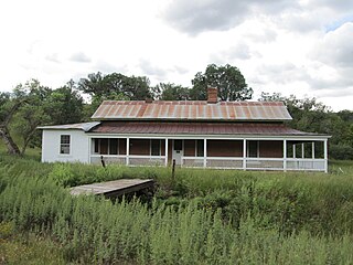
The buildings and land were purchased by an attorney for the McAneny family and until the 1960s the lands were used as a cattle ranch. During the 1960s the land was sold to ANAMAX Mining. The Forest Service acquired the land in 1989 and added it to the Coronado National Forest. The Forest Service is currently working with volunteers and others to preserve and interpret Kentucky Camp as a historic site related to mining in the American west. [3]

Pima County is a county in the south central region of the U.S. state of Arizona. As of the 2020 census, the population was 1,043,433, making it Arizona's second-most populous county. The county seat is Tucson, where most of the population is centered. The county is named after the Pima Native Americans who are indigenous to this area.

Oro Valley, incorporated in 1974, is a suburban town located 6 miles (9.7 km) north of Tucson, Arizona, United States, in Pima County. According to the 2020 census, the population of the town is 47,070, an increase from 29,700 in 2000. Dubbed the "Upscale Tech Mecca" of Southern Arizona by the Arizona Daily Star newspaper, Oro Valley is home to over 10 high tech firms and has a median household income nearly 50% higher than the U.S. median. The town is located approximately 110 miles (180 km) southeast of the state capital of Phoenix.

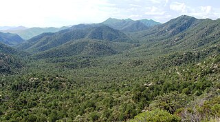
The Santa Rita Mountains, located about 65 km (40 mi) southeast of Tucson, Arizona, extend 42 km (26 mi) from north to south, then trending southeast. They merge again southeastwards into the Patagonia Mountains, trending northwest by southeast. The highest point in the range, and the highest point in the Tucson area, is Mount Wrightson, with an elevation of 9,453 feet, The range contains Madera Canyon, one of the world's premier birding areas. The Smithsonian Institution's Fred Lawrence Whipple Observatory is located on Mount Hopkins. The range is one of the Madrean sky islands.
The Coronado National Forest is a United States National Forest that includes an area of about 1.78 million acres (7,200 km2) spread throughout mountain ranges in southeastern Arizona and southwestern New Mexico.

The Santa Catalina Mountains, commonly referred to as the Catalina Mountains or the Catalinas, are north and northeast of Tucson in Arizona, United States, on Tucson's north perimeter. The mountain range is the most prominent in the Tucson area, with the highest average elevation. The highest point in the Catalinas is Mount Lemmon at an elevation of 9,157 feet (2,791 m) above sea level and receives 18 inches (46 cm) of precipitation annually.

The Rincon Mountains are a significant mountain range east of Tucson, Pima County, Arizona, in the United States. The Rincon Mountains are one of five mountain ranges surrounding the Tucson valley. The other ranges include the most prominent, the Santa Catalina Mountains to the north, the Santa Rita Mountains to the south, the Tucson Mountains to the west, and the Tortolita Mountains to the northwest. Redington Pass separates the Rincon Mountains from the Santa Catalina Mountains. The Rincon Mountains are generally less rugged than the Santa Catalina Mountains and Santa Rita Mountains. The Rincon Mountains are also included in the Madrean sky island mountain ranges of southeast Arizona, extreme southwest New Mexico, and northern Sonora Mexico.
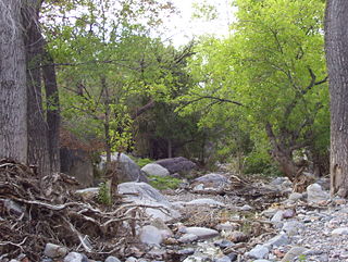
Madera Canyon is a canyon in the northwestern face of the Santa Rita Mountains, twenty-five miles southeast of Tucson, Arizona. As part of the Coronado National Forest, Madera Canyon has campsites, picnic areas, and miles of hiking trails. The canyon is also used as a resting place for migrating birds, and it is thus known as a premier birdwatching area. Madera Canyon was originally named White House Canyon, after a prominent white adobe house was built there in the late 19th century. The canyon was renamed sometime in the early 1900s, although some locals still use the original name.

Ruby is a ghost town in Santa Cruz County, Arizona, United States. It was founded as a mining town in Bear Valley, originally named Montana Camp, so named because the miners were mining at the foot of Montana Peak.
Fort Lowell was a United States Army post active from 1873 to 1891 on the outskirts of Tucson, Arizona. Fort Lowell was the successor to Camp Lowell, an earlier Army installation. The Army chose a location just south of the confluence of the Tanque Verde and Pantano creeks, at the point where they form the Rillito River, due to the year-round supply of water during that period. The Hohokam natives had chosen the site centuries earlier, presumably for the same reason. To this day, shards of Hohokam pottery can still be found in the area. The Army claimed a military reservation that encompassed approximately eighty square miles and extended east toward the Rincon Mountains.

Helvetia is a ghost town in Pima County, Arizona, United States that was settled in 1891 and abandoned in the early 1920s. Helvetia is an ancient name for Switzerland.

Harshaw is a ghost town in Santa Cruz County in the southeastern part of the U.S. state of Arizona. The town was settled in the 1870s, in what was then Arizona Territory. Founded as a mining community, Harshaw is named after the cattleman-turned-prospector David Tecumseh Harshaw, who first successfully located silver in the area. At the town's peak near the end of the 19th century, Harshaw's mines were among Arizona's highest producers of ore, with the largest mine, the Hermosa, yielding approximately $365,455 in bullion over a four-month period in 1880.

Empire Ranch is a working cattle ranch in southeastern Pima County, Arizona, that was placed on the National Register of Historic Places in 1976. In its heyday, Empire Ranch was one of the largest in Arizona, with a range spanning over 180 square miles (470 km2), and its owner, Walter L. Vail, was an important figure in the establishment of southern Arizona's cattle industry. It is currently owned by the Bureau of Land Management with a grazing lease to a private operator.
Rosemont Copper is a proposed large open pit copper mine project by the Canadian mining corporation Hudbay Minerals. The project site is located within the Santa Rita Mountains and Coronado National Forest, in Pima County of southern Arizona. It has undergone a permitting review process under the direction of the United States Forest Service and the U.S. Army Corps of Engineers and has been delayed by legal judgements and suspension of its operating permit by the US Army Corps of Engineers.

Cienega Valley is a valley located southeast of Tucson, Arizona, in the transition zone between the Sonoran and Chihuahuan Deserts. It is bounded by the Rincon Mountains to the north, the Whetstone Mountains to the east, the Mustang Mountains to the southeast, the Canelo Hills to the south, and the Santa Rita-Empire Mountains complex to the west. Much of the area is now part of the Las Cienegas National Conservation Area, which preserves habitat for a variety of threatened plant and animal species in the valley and along Cienega Creek.
The James Finley House is a historic home located on the Hale Ranch in the ghost town of Harshaw, Arizona. Built around 1877, the house was added to the National Register of Historic Places in 1974, and is now the most prominent building remaining in this ghost town. Along with the rest of Harshaw, this house has been within the Coronado National Forest since 1953.

Salero is a ghost town in the Santa Rita Mountains of Santa Cruz County, Arizona. As one of the best preserved ghost towns remaining in Arizona, Salero is located on private property of the Salero Ranch and is not open to visitors.

Alto is a ghost town in Santa Cruz County, Arizona, first settled in the early 1900s in what was then part of the Tyndall Mining District, east of Tubac in the Santa Rita Mountains. The town was originally named El Plomo, which is Spanish for "lead", and was changed to Alto, meaning "high", many years later, probably because the mines were located high up on a steep mountainside.
Between the years of 1539 and 1821, the Spanish Empire explored, colonized, and ruled over what is the state of Arizona in the United States.