The Fan is a district of Richmond, Virginia, so named because of the "fan" shape of the array of streets that extend west from Belvidere Street, on the eastern edge of Monroe Park, westward to Arthur Ashe Boulevard. However, the streets rapidly resemble a grid after they go through what is now Virginia Commonwealth University. The Fan is one of the easterly points of the city's West End section, and is bordered to the north by Broad Street and to the south by VA 195, although the Fan District Association considers the southern border to be the properties abutting the south side of Main Street. The western side is sometimes called the Upper Fan and the eastern side the Lower Fan, though confusingly the Uptown district is located near VCU in the Lower Fan. Many cafes and locally owned restaurants are located here, as well as historic Monument Avenue, a boulevard formerly featuring statuary of the Civil War's Confederate president and generals. The only current statue is a more modern one of tennis icon Arthur Ashe. Development of the Fan district was strongly influenced by the City Beautiful movement of the late 19th century.

West Adams is a historic neighborhood in the South Los Angeles region of Los Angeles, California. The area is known for its large number of historic buildings, structures and notable houses and mansions.

Downtown Phoenix is the central business district (CBD) of the City of Phoenix, Arizona, United States. It is in the heart of the Phoenix metropolitan area or Valley of the Sun. Phoenix, being the county seat of Maricopa County and the capital of Arizona, serves as the center of politics, justice and government on the local, state and federal levels. The area is a major center of employment for the region, with many financial, legal, and other national and international corporations housed in a variety of skyscrapers. Major arts and cultural institutions also call the area home. Downtown Phoenix is a center of major league sports activities, live concert events, and is an equally prominent center of banking and finance in Arizona. Regional headquarters for several major banks, including JP Morgan Chase, Wells Fargo, US Bank, Bank of America, Compass Bank and Midfirst Bank are all located within or close proximity to the area.

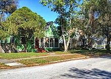
California bungalow is an alternative name for the American Craftsman style of residential architecture, when it was applied to small-to-medium sized homes rather than the large "ultimate bungalow" houses of designers like Greene and Greene. California bungalows became popular in suburban neighborhoods across the United States, and to varying extents elsewhere, from around 1910 to 1939.

Angelino Heights, alternately spelled Angeleno Heights, is one of the oldest neighborhoods in Los Angeles. Situated between neighboring Chinatown and Echo Park, the neighborhood is known for its concentration of eclectic architectural styles from three eras: The Victorian, Turn of the Century and Revival eras. Carroll Avenue is listed on the National Register of Historic Places and there are over thirty Historic-Cultural Monuments in the neighborhood.

University Heights is a neighborhood in Central San Diego, California centered on Park Boulevard and Adams Avenue. University Heights is bounded on the west and north by the edge of the mesa, the southern boundary is Lincoln Avenue, and the eastern boundary is Boundary Street along the western edge of Interstate 805. The area is filled with a number of restaurants, coffee shops, boutiques, and artist studios primarily on Park Boulevard and Adams Avenue. Live entertainment can be found most nights. Adjacent to Hillcrest, Normal Heights and North Park, additional restaurants, bars, coffee shops, and night clubs are within easy reach.
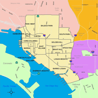
South Park is a neighborhood in San Diego, California adjacent to the southeast corner of Balboa Park. It stands out in San Diego for its tree-lined streets and walkable business district.

There are more than 500 neighborhoods within the area of Jacksonville, Florida, the largest city in the contiguous United States by area. These include Downtown Jacksonville and surrounding neighborhoods. Additionally, greater Jacksonville is traditionally divided into several major sections with amorphous boundaries: Northside, Westside, Southside, and Arlington, as well as the Jacksonville Beaches.

Neighborhoods in Spokane, Washington are officially grouped by the Spokane City Council into three main city council districts: 1, 2, and 3. Each city council district contains multiple, official neighborhoods that are recognized with a neighborhood council. Informally, neighborhoods are colloquially grouped by local geographical, geological, cultural, or historical features The list of neighborhoods below is organized based on the official designations by the City of Spokane. Unofficial neighborhoods and districts are listed within the official neighborhood in which they are located.

Hillcrest Historic District is an historic neighborhood in Little Rock, Arkansas that was listed on the National Register of Historic Places on December 18, 1990. It is often referred to as Hillcrest by the people who live there, although the district's boundaries actually encompass several neighborhood additions that were once part of the incorporated town of Pulaski Heights. The town of Pulaski Heights was annexed to the city of Little Rock in 1916. The Hillcrest Residents Association uses the tagline "Heart of Little Rock" because the area is located almost directly in the center of the city and was the first street car suburb in Little Rock and among the first of neighborhoods in Arkansas.
Columbus, the state capital and Ohio's largest city, has numerous neighborhoods within its city limits. Neighborhood names and boundaries are not officially defined. They may vary or change from time to time due to demographic and economic variables.

Shasta Hanchett Park is a historic residence park and neighborhood in the greater Rose Garden district of central San Jose, California, near Downtown San Jose and The Alameda.

Capitol View/Stifft's Station is a neighborhood of Little Rock, Arkansas, in the west-central portion of the city encompassing approximately 1500 homes. Roughly, its boundaries include the area south of West Markham, north of Interstate 630, east of Pine, and west of Summit, as well as south of Riverview between Park and Summit. Capitol View/Stifft's Station is just west of Downtown, north of the Central High School Historic District, southeast of Pulaski Heights and uses the 72205 ZIP code.

The Drake Park Neighborhood Historic District is located adjacent to Drake Park near the historic downtown area in Bend, Oregon, United States. Because of the unique and varied architecture in the Drake Park neighborhood and its close association with the early development of the city of Bend, the area was listed on the National Register of Historic Places in 2005.

Midtown has an area of six square miles in Columbus, Georgia. It possesses residential neighbourhoods, eleven public schools, the Columbus Museum, the Columbus Public Library, the Muscogee County Public Education Center, the Columbus Aquatic Center and the international headquarters for Aflac. The population of Midtown is 22,000 residents living in 8500 households and is 10 kilometres north of Fort Benning on I-185.

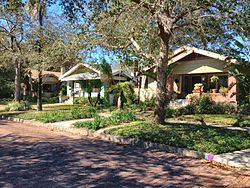
There are nine historic districts in Meridian, Mississippi. Each of these districts is listed on the National Register of Historic Places. One district, Meridian Downtown Historic District, is a combination of two older districts, Meridian Urban Center Historic District and Union Station Historic District. Many architectural styles are present in the districts, most from the late 19th century and early 20th century, including Queen Anne, Colonial Revival, Italianate, Art Deco, Late Victorian, and Bungalow.
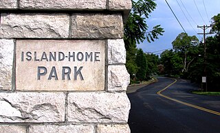
Island Home Park is a neighborhood in Knoxville, Tennessee, United States, located in the southeastern part of the city along the Tennessee River. Developed as a streetcar suburb in the early 1900s, the neighborhood retains most of its original houses and streetscapes, and is home to the city's largest concentration of Bungalow-style houses. In 1994, several dozen houses in Island Home Park were added to the National Register of Historic Places as the Island Home Park Historic District.

Riverside and Avondale are two adjacent and closely associated neighborhoods, alternatively considered one continuous neighborhood, of Jacksonville, Florida. The area is primarily residential, but includes some commercial districts, including Five Points, the King Street District, and the Shoppes of Avondale.

Scottholm is an historic housing development in the Meadowbrook neighborhood of Syracuse, Onondaga County, New York. It has been registered as a National Historic District. It is bounded by Salt Springs Road on the north; Brookford Road and East Avenue on the east; Meadowbrook Drive on the south; and Scottholm Terrace on the west. Scottholm consists of single‐family homes of varying styles built in the early 20th century. When it was built, Scottholm was marketed to upper middle class and upper class residents. Today, the area attracts a diverse population of white collar, academic, and creative class professionals. Nottingham High School, in the Syracuse City School District, is nearby.