North Tyneside is a metropolitan borough in the metropolitan county of Tyne and Wear, England. It forms part of the greater Tyneside conurbation. North Tyneside Council is headquartered at Cobalt Park, Wallsend.

Lambeth was a civil parish and metropolitan borough in south London, England. It was an ancient parish in the county of Surrey. The parish was included in the area of responsibility of the Metropolitan Board of Works in 1855 and became part of the County of London in 1889. The parish of Lambeth became a metropolitan borough in 1900, following the London Government Act 1899, with the parish vestry replaced by a borough council.

Battersea was a civil parish and metropolitan borough in the County of London, England. In 1965, the borough was abolished and its area combined with parts of the Metropolitan Borough of Wandsworth to form the London Borough of Wandsworth. The borough was administered from Battersea Town Hall on Lavender Hill. That building is now Battersea Arts Centre.

Cramlington is a town and civil parish in Northumberland, England, 6 miles north of Newcastle upon Tyne, and 10 miles north of its city centre. The name suggests a probable founding by the Danes or Anglo-Saxons. The population was 29,405 as of 2011 census data from Northumberland County Council. It sits on the border between Northumberland and North Tyneside with the traffic interchange at Moor Farm, Annitsford, linking the two areas.

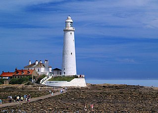
North Shields is a town in the Borough of North Tyneside in Tyne and Wear, England. It is 8 miles (13 km) north-east of Newcastle upon Tyne and borders nearby Wallsend and Tynemouth.

Newcastle is a village in the rural south west of Shropshire, England. It lies at the confluence of the River Clun and the Folly Brook, 3 miles west of the small town of Clun. The B4368 runs through the village, on its way between Craven Arms in Shropshire to Newtown in Powys.

Bellingham is a village and civil parish in Northumberland, to the north-west of Newcastle upon Tyne and is situated on the Hareshaw Burn at its confluence with the River North Tyne.
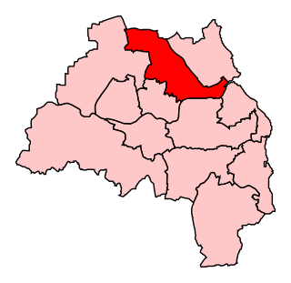
North Tyneside is a constituency represented in the House of Commons of the UK Parliament since 2010 by Mary Glindon of the Labour Party.

Whitburn is a village in South Tyneside, in the metropolitan county of Tyne and Wear on the coast of North East England. It is located 3 miles (4.8 km) north of the city of Sunderland and 4 miles (6.4 km) south of the town of South Shields. Historically, Whitburn was a part of County Durham. Other nearby population centres include Seaburn, Cleadon and Marsden. The village lies on a south-facing slope, part of Durham's Magnesian Limestone plateau, which overlooks Sunderland. The population for the combined Whitburn and Marsden Ward in the 2011 UK Census was 7,448. For much of its history, Whitburn was a fishing and agricultural community. The village contains three schools, three churches, a cricket club, recreational grounds, a pub and a variety of shops.

Newcastle Cathedral, formally the Cathedral Church of St Nicholas, is a Church of England cathedral in Newcastle upon Tyne, Tyne and Wear, England. It is the seat of the Bishop of Newcastle and is the mother church of the Diocese of Newcastle.
Norley is a village and civil parish in Cheshire, England, north of Delamere Forest, near the village of Cuddington. The population at the 2011 census was 1,169. Its name is derived from “Norlegh”, which means “north clearing”.

Longbenton is a district of North Tyneside, England. It is largely occupied by an extensive estate originally built as municipal housing by Newcastle City Council in the 1930s and extended in the 1950s. It is served by the Tyne and Wear Metro stations Longbenton Metro station and Four Lane Ends Metro Station. Nearby places are Killingworth, Forest Hall, Four Lane Ends, West Moor, Heaton and South Gosforth, in Newcastle upon Tyne. The Longbenton and Killingworth Urban Area had a population of 34,878 in 2001. This figure increased to 37,070 in 2011.

Gosforth is a suburb of the city and metropolitan borough of Newcastle upon Tyne, England. It constituted a separate urban district from 1895 until 1974 before officially merging with the city of Newcastle upon Tyne. In 2001, it had a population of 23,620.

Cleadon is a suburban village in South Tyneside in the North East of England. Prior to the creation of Tyne and Wear in 1974 by the Local Government Act 1972, the village was part of the historic County Durham. In the 2011 UK Census the population of the South Tyneside ward of Cleadon and East Boldon was 8,427. Nearby population centres include East Boldon, Whitburn, and Jarrow. The village is located approximately 5 miles (8 km) from the city of Sunderland and 5 miles from the town South Shields. It is situated on the south west of Cleadon Hills, an example of a Magnesian Limestone grassland home to a number of regionally and nationally rare species.

Kingsley is a civil parish and a village in the unitary authority of Cheshire West and Chester and the ceremonial county of Cheshire, England. It is approximately 5 miles south east of the town of Frodsham.
Forest Hall is a village in the borough of North Tyneside, Tyne and Wear, England. It is 4 miles from Newcastle upon Tyne. It borders Killingworth to the north, Holystone to the east and Benton to the south. The village has seen a slight increase in antisocial behaviour in recent years. The village was named after the Forest Hall, which incorporated a medieval tower. Woodside Court was built on the site of the Hall, which was demolished in 1962.

Hatfield Broad Oak is a village and civil parish in the Uttlesford district of Essex, England. The village is approximately 5 miles (8 km) south-east of Bishop's Stortford. Near the church of St Mary the Virgin is former Benedictine priory Hatfield Regis Priory.

Northrepps is a village and a civil parish in the English county of Norfolk. It is 3.4 miles (5.5 km) southeast of Cromer, 22.2 miles (35.7 km) north of Norwich and 137 miles (220 km) north of London. The village lies west of the A149 which runs between Kings Lynn and Great Yarmouth. The nearest railway station is at Cromer for the Bittern Line which runs between Sheringham, Cromer and Norwich. The nearest airport is Norwich International Airport. The village and parish of Northrepps had in the 2001 census a population of 839, increasing to 886 at the 2011 Census. For the purposes of local government, the village falls within the district of North Norfolk.
Percy Main is a small village absorbed into North Shields, North East England. Historically in Northumberland, it is now part of Tyne and Wear.


