Kimberley | |
---|---|
City of Kimberley | |
Motto(s): | |
Location of Kimberley in British Columbia | |
Coordinates: 49°40′11″N115°58′39″W / 49.66972°N 115.97750°W Coordinates: 49°40′11″N115°58′39″W / 49.66972°N 115.97750°W | |
Country | Canada |
Province | British Columbia |
Regional District | East Kootenay |
Incorporation (city) | March 29, 1944 [1] |
Amalgamation | November 1, 1968 [2] |
Government | |
• Mayor | Don McCormack |
Elevation | 1,120 m (3,670 ft) |
Population (2021) [3] | |
• Total | 8,115 |
• Density | 122.5/km2 (317/sq mi) |
Time zone | UTC-7 (MST) |
Forward sortation area | |
Area code(s) | 250, 778, 236, 672 |
Highways | Hwy 95A |
Website | www |
Kimberley is a city in southeast British Columbia, Canada along Highway 95A between the Purcell and Rocky Mountains. Kimberley was named in 1896 after the Kimberley mine in South Africa. From 1917 to 2001, it was the home to the world's largest lead-zinc mine, the Sullivan Mine. Now it is mainly a tourist destination and home to the Kimberley Alpine Resort, a ski area and Kimberley's Underground Mining Railway that features a 750-foot-long (230 m) underground mining interpretive centre complete with operational 3 ft (914 mm) narrow-gauge railway equipment. Recreational pursuits include world-class skiing, snowboarding, snowmobiling, fishing, whitewater rafting, kayaking, biking, hiking and golfing on championship golf courses. The city has the largest urban park in Canada. At 1,977 acres (800 ha), the Kimberley Nature Park is the largest incorporated park in Canada.
SunMine, was the largest solar PV plant in Western Canada when built in 2015 on the site of the former Sullivan Mine concentrator. [4]
Kimberley incorporated as a city on March 29, 1944. [1] It amalgamated with the former Village of Marysville on November 1, 1968. [2] Following the routing of Highway 95 away from the city, in 1972 Kimberley transformed into the Bavarian City of the Rockies to entice motorists passing through the region to visit. Kimberley's Mine was the Sullivan Mine, and it was the largest lead-zinc mine in the world. The mine ceased operation in 2001.
Year | Pop. | ±% |
---|---|---|
1951 | 5,933 | — |
1956 | 5,774 | −2.7% |
1961 | 6,013 | +4.1% |
1966 | 5,901 | −1.9% |
1971 | 7,840 | +32.9% |
1976 | 7,111 | −9.3% |
1981 | 7,375 | +3.7% |
1986 | 6,732 | −8.7% |
1991 | 6,531 | −3.0% |
1996 | 6,738 | +3.2% |
2001 | 6,484 | −3.8% |
2006 | 6,139 | −5.3% |
2011 | 6,652 | +8.4% |
2016 | 7,425 | +11.6% |
2021 | 8,115 | +9.3% |
Source: Statistics Canada [5] [6] [7] [8] [9] [10] [11] [12] |
In the 2021 Census of Population conducted by Statistics Canada, Kimberley had a population of 8,115 living in 3,595 of its 4,263 total private dwellings, a change of 9.3% from its 2016 population of 7,425. With a land area of 60.51 km2 (23.36 sq mi), it had a population density of 134.1/km2 (347.3/sq mi) in 2021. [13]
Although its historical population was closely tied to activities at the Sullivan Mine, the city's high-speed internet and scenic location enabled growth in tech and tourism beginning in the 2000s. [14]
Panethnic group | 2021 [15] | 2016 [16] | 2011 [17] | 2006 [18] | 2001 [19] | 1996 [20] | ||||||||
---|---|---|---|---|---|---|---|---|---|---|---|---|---|---|
Pop. | % | Pop. | % | Pop. | % | Pop. | % | Pop. | % | Pop. | % | |||
European [lower-alpha 1] | 7,230 | 91% | 6,665 | 92.12% | 5,930 | 91.58% | 5,725 | 94.78% | 6,115 | 95.7% | 6,345 | 95.2% | ||
Indigenous | 475 | 5.98% | 375 | 5.18% | 395 | 6.1% | 225 | 3.73% | 165 | 2.58% | 155 | 2.33% | ||
East Asian [lower-alpha 2] | 90 | 1.13% | 95 | 1.31% | 50 | 0.77% | 60 | 0.99% | 30 | 0.47% | 80 | 1.2% | ||
South Asian | 45 | 0.57% | 20 | 0.28% | 30 | 0.46% | 10 | 0.17% | 25 | 0.39% | 30 | 0.45% | ||
Southeast Asian [lower-alpha 3] | 45 | 0.57% | 70 | 0.97% | 0 | 0% | 10 | 0.17% | 15 | 0.23% | 15 | 0.23% | ||
Latin American | 40 | 0.5% | 10 | 0.14% | 0 | 0% | 0 | 0% | 0 | 0% | 10 | 0.15% | ||
African | 10 | 0.13% | 10 | 0.14% | 0 | 0% | 10 | 0.17% | 40 | 0.63% | 25 | 0.38% | ||
Middle Eastern [lower-alpha 4] | 0 | 0% | 0 | 0% | 0 | 0% | 0 | 0% | 0 | 0% | 0 | 0% | ||
Other/Multiracial [lower-alpha 5] | 0 | 0% | 0 | 0% | 0 | 0% | 10 | 0.17% | 0 | 0% | 0 | 0% | ||
Total responses | 7,945 | 97.91% | 7,235 | 97.44% | 6,475 | 97.34% | 6,040 | 98.39% | 6,390 | 98.55% | 6,665 | 98.92% | ||
Total population | 8,115 | 100% | 7,425 | 100% | 6,652 | 100% | 6,139 | 100% | 6,484 | 100% | 6,738 | 100% | ||
Note: Totals greater than 100% due to multiple origin responses |
According to the 2021 census, religious groups in Kimberley included: [15]
The city has the "largest freestanding cuckoo clock in Canada". It began to develop a Bavarian-themed village in the 1970s after taking inspiration from Leavenworth, Washington. [21] Kimberley no longer has a bavarian theme.
Kimberley is served by the Canadian Rockies International Airport.
Schools in Kimberley are part of School District 6 Rocky Mountain which also serves Invermere and Golden.
Other schools accredited by the government:
Kimberley has a continental climate with semi-arid influences and heavy moderation from the nearby mountains which tend to block arctic air masses, and produce a rain shadow. Its fairly high elevation counters this effect slightly, as temperatures are somewhat cooler and the town slightly more rainy than it would otherwise be.
Climate data for Kimberley | |||||||||||||
---|---|---|---|---|---|---|---|---|---|---|---|---|---|
Month | Jan | Feb | Mar | Apr | May | Jun | Jul | Aug | Sep | Oct | Nov | Dec | Year |
Record high °C (°F) | 12.5 (54.5) | 14.0 (57.2) | 22.0 (71.6) | 26.0 (78.8) | 31.5 (88.7) | 34.0 (93.2) | 37.0 (98.6) | 36.0 (96.8) | 34.0 (93.2) | 26.5 (79.7) | 17.0 (62.6) | 8.5 (47.3) | 37.0 (98.6) |
Average high °C (°F) | −1.7 (28.9) | 2.1 (35.8) | 7.6 (45.7) | 13.5 (56.3) | 18.2 (64.8) | 21.7 (71.1) | 26.5 (79.7) | 26.3 (79.3) | 21.0 (69.8) | 12.3 (54.1) | 3.1 (37.6) | −2.5 (27.5) | 12.3 (54.1) |
Daily mean °C (°F) | −6.8 (19.8) | −4.1 (24.6) | 1.2 (34.2) | 6.5 (43.7) | 11.0 (51.8) | 14.5 (58.1) | 18.1 (64.6) | 17.6 (63.7) | 12.6 (54.7) | 5.6 (42.1) | −1.4 (29.5) | −6.8 (19.8) | 5.7 (42.3) |
Average low °C (°F) | −11.9 (10.6) | −10.3 (13.5) | −5.3 (22.5) | −0.6 (30.9) | 3.8 (38.8) | 7.2 (45.0) | 9.7 (49.5) | 8.9 (48.0) | 4.2 (39.6) | −1.1 (30.0) | −6.0 (21.2) | −11.2 (11.8) | −1.0 (30.2) |
Record low °C (°F) | −36.5 (−33.7) | −35.5 (−31.9) | −26.0 (−14.8) | −11.0 (12.2) | −4.5 (23.9) | −1.5 (29.3) | 0.5 (32.9) | −2.0 (28.4) | −2.5 (27.5) | −7.0 (19.4) | −19.0 (−2.2) | −31.0 (−23.8) | −35.0 (−31.0) |
Average precipitation mm (inches) | 39.2 (1.54) | 28.9 (1.14) | 26.6 (1.05) | 28.2 (1.11) | 42.7 (1.68) | 55.8 (2.20) | 36.2 (1.43) | 27.0 (1.06) | 30.9 (1.22) | 25.8 (1.02) | 45.6 (1.80) | 44.7 (1.76) | 431.6 (16.99) |
Average rainfall mm (inches) | 5.1 (0.20) | 5.0 (0.20) | 13.6 (0.54) | 24.0 (0.94) | 41.5 (1.63) | 55.8 (2.20) | 36.2 (1.43) | 27.0 (1.06) | 30.5 (1.20) | 22.0 (0.87) | 18.6 (0.73) | 4.1 (0.16) | 283.4 (11.16) |
Average snowfall cm (inches) | 39.2 (15.4) | 23.9 (9.4) | 13.2 (5.2) | 4.2 (1.7) | 1.2 (0.5) | 0.0 (0.0) | 0.0 (0.0) | 0.0 (0.0) | 0.4 (0.2) | 2.8 (1.1) | 27.0 (10.6) | 40.6 (16.0) | 148.4 (58.4) |
Source: Environment Canada [22] |
The Kimberley Dynamiters Junior B Ice Hockey team play in the Kootenay International Junior Hockey League (KIJHL). The Dynamiters have produced many professional hockey players, including Jason Wiemer, who last played with the New Jersey Devils of the National Hockey League (NHL).
There are three major golf courses to play in Kimberley; Purcell Golf, Bootleg Gap and Trickle Creek Golf Resort. Just 15 – 20 minutes away are St. Eugene Golf Resort, Wildstone Golf and Shadow Mountain Golf Course. There are many other golf courses in the East Kootenay region.
Kimberley is home to the Worlds Longest Running Skateboard Race called the Sullivan Challenge.
Mountain biking is a summer sport of Kimberley, with over 100km of trails for every skill level.
Kimberley Alpine Resort owned by the Resort of the Canadian Rockies, regularly hosts ski races on the [[Para Alpine Skiing]]. It offers a wide range of runs, for all levels. Kimberley Alpine Resort is also home to the Winter Sports School which hosts lessons for all ages and abilities.
There is an annual ultra marathon at Kimberley Alpine Resort, the Black Spur Ultra. Runners choose between 54 km and 108 km distances. [23]
Club | League | Sport | Venue | Established | Championships |
---|---|---|---|---|---|
Kimberley Dynamiters | KIJHL | Ice Hockey | Kimberley Civic Centre | 1972 | 3 |
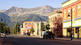
Fernie is a city in the Elk Valley area of the East Kootenay region of southeastern British Columbia, Canada, located on BC Highway 3 on the western approaches to the Crowsnest Pass through the Rocky Mountains. Founded in 1898 and incorporated as the City of Fernie in July 1904, the municipality has a population of over 5,000 with an additional 2,000 outside city limits in communities under the jurisdiction of the Regional District of East Kootenay. A substantial seasonal population swells the city during the winter months.
Invermere is a community in eastern British Columbia, Canada, near the border of Alberta. It is the hub of the Columbia Valley between Golden to the north and Cranbrook to the south. Invermere sits on the northwest shore of Windermere Lake and is a popular summer destination for visitors and second home owners from Edmonton and Calgary.
Cranbrook is a city in southeast British Columbia, Canada, located on the west side of the Kootenay River at its confluence with the St. Mary's River. It is the largest urban centre in the region known as the East Kootenay. As of 2016, Cranbrook's population is 20,499 with a census agglomeration population of 27,040. It is the location of the headquarters of the Regional District of East Kootenay and also the location of the regional headquarters of various provincial ministries and agencies, notably the Rocky Mountain Forest District.
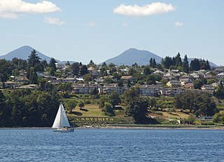
Ladysmith, originally Oyster Harbour, is a town located on the 49th parallel north on the east coast of Vancouver Island, British Columbia, Canada. The local economy is based on forestry, tourism, and agriculture. A hillside location adjacent to a sheltered harbour forms the natural geography of the community.
Sparwood is a district municipality in the Canadian province of British Columbia. It is the second-largest community on the Elk River.
Cochrane is a town in the Calgary Metropolitan Region of Alberta, Canada. The town is located 18 km (11 mi) west of the Calgary city limits along Highway 1A. Cochrane is one of the fastest-growing communities in Canada, and with a population of 32,199 in 2021, it is one of the largest towns in Alberta. It is part of Calgary's census metropolitan area and a member community of the Calgary Metropolitan Region Board (CMRB). The town is surrounded by Rocky View County.
Airdrie is a city in Alberta, Canada within the Calgary Region. It is located north of Calgary within the Calgary–Edmonton Corridor at the intersection of Queen Elizabeth II Highway and Highway 567.
Golden is a town in southeastern British Columbia, Canada, 262 kilometres (163 mi) west of Calgary, Alberta, and 713 kilometres (443 mi) east of Vancouver.
The Thompson–Nicola Regional District is a regional district in the Canadian province of British Columbia. The Canada 2021 Census population was 143,680 and the area covers 44,449.49 square kilometres. The administrative offices are in the main population centre of Kamloops, which accounts for 78 percent of the regional district's population. The only other city is Merritt; other municipally-incorporated communities include the District Municipalities of Logan Lake, Barriere and Clearwater and the Villages of Chase, Ashcroft, Cache Creek, Clinton and Lytton, and also the Mountain Resort Municipality of Sun Peaks.
The Calgary Metropolitan Region (CMR), also commonly referred to as the Calgary Region, is a conglomeration of municipalities centred on Calgary, the largest city in Alberta.
The Regional District of East Kootenay (RDEK) is a regional district in the Canadian province of British Columbia, Canada. In the 2016 census, the population was 60,439. Its area is 27,542.69 km2 (10,634.29 sq mi). The regional district offices are in Cranbrook, the largest community in the region. Other important population centres include the cities of Kimberley and Fernie, and the district municipality of Invermere and Sparwood. Despite its name, the regional district does not include all of the region known as the East Kootenay, which includes the Creston Valley and the east shore of Kootenay Lake.
Beaumont is a city in Leduc County within the Edmonton Metropolitan Region of Alberta, Canada. It is located at the intersection of Highway 625 and Highway 814, adjacent to the City of Edmonton and 6.0 kilometres (3.7 mi) northeast of the City of Leduc. The Nisku Industrial Park and the Edmonton International Airport are located 4.0 kilometres (2.5 mi) to the west and 8.0 kilometres (5.0 mi) to the southwest respectively.
Vanderhoof is a district municipality near the geographical centre of British Columbia, Canada. Covering 2.92 square kilometers., it has a population of about 4,500 within town limits, and offers services to nearly 10,000 people in nearby rural communities. Its main industries are forestry, agriculture, and related businesses. Tourism is also growing, and mining operations are being developed in the area. It has many elementary schools, and one major secondary school, Nechako Valley Secondary School (NVSS), comprising School District 91 Nechako Lakes. The College of New Caledonia has a regional campus there.
Mackenzie is a district municipality within the Fraser-Fort George Regional District in central British Columbia, Canada. The community is located at the south end of Williston Lake. The townsite, established by Alexandra Forest Industries and Cattermole Timber, was named for Sir Alexander MacKenzie (1764–1820).
Chestermere, originally named Chestermere Lake, is a city in the Canadian province of Alberta, within Rocky View County. It is largely a commuter town of Calgary and is a member municipality of the Calgary Region. The city, which surrounds Chestermere Lake, was known as Chestermere Lake from 1977 to 1993.
Grand Forks, population 4,112, is a city in the Boundary Country of the West Kootenay region of British Columbia, Canada. It is located at the confluence of the Granby and Kettle Rivers, a tributary of the Columbia River. The city is just north of the Canada–United States border, approximately 500 km (310 mi) from Vancouver and 200 km (120 mi) from Kelowna and 23 km (14 mi) west of the resort area of Christina Lake by road.
The Northern Rockies Regional Municipality (NRRM), formerly the Northern Rockies Regional District (NRRD), and before that the Fort Nelson–Liard Regional District, is a municipality in northeastern British Columbia, Canada. Although portrayed as a regional municipality in its official name, and existing on the same administrative level as a regional district, it is actually classified as a district municipality. The NRRM's offices are located in Fort Nelson, formerly an incorporated town that amalgamated with the NRRD on February 6, 2009 to form the NRRM. With the Peace River Regional District as the southern part, it was the northern part of the Peace River-Liard Regional District, which was split into two on October 31, 1987.
Houston is a forestry, mining and tourism town in the Bulkley Valley of the Northern Interior of British Columbia, Canada. Its urban population is approximately 3600 people, with approximately 2000 in the surrounding rural area. It is known as the "steelhead capital" and it has the world's largest fly fishing rod. Houston's tourism industry is largely based on ecotourism and Steelhead Park, situated along Highway 16. Houston is named in honour of the pioneer newspaperman John Houston.
According to the 2021 census, the City of Edmonton had a population of 1,010,899 residents, compared to 4,262,635 for all of Alberta, Canada. The total population of the Edmonton census metropolitan area (CMA) was 1,418,118, making it the sixth-largest CMA in Canada.
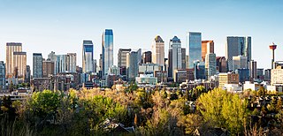
In the 2021 Census, the City of Calgary had a population of 1,306,784 residents, representing 30.7% of the 4,262,635 residents in all of Alberta, and 3.5% compared to a population of 36,991,981 in all of Canada. The total population of the Calgary census metropolitan area (CMA) was 1,481,806. Calgary is the largest city in Alberta, and the third-largest municipality and fifth-largest metropolitan area in Canada, as of 2021.