Councils of Tasmania are the 29 administrative districts of the Australian state of Tasmania. Local government areas (LGAs), more generally known as councils, are the tier of government responsible for the management of local duties such as road maintenance, town planning and waste management.
Kingston is a town on the outskirts of Hobart, Tasmania, Australia. Nestled 12 km south of the city between and around several hills, Kingston is the seat of the Kingborough Council, and today serves as the gateway between Hobart and the D'Entrecasteaux Channel region, which meets the Derwent River nearby. It is one of the fastest-growing regions in Tasmania. The Kingston-Huntingfield statistical area had an estimated population of 11,200 in June 2012.
Margate is a small seaside town on the Channel Highway between North-West Bay and the Snug Tiers, 7 kilometres (4 mi) south of Kingston in Tasmania, Australia. It is mostly in the Kingborough Council area, with about 4% in the Huon Valley Council LGA. Margate is also part of the Greater Hobart statistical area.

Taroona is a major residential suburb approximately 15 minutes drive from the centre of Hobart, Tasmania on the scenic route between Hobart and Kingston. Although on the edges of the City of Hobart, Taroona is actually part of the municipality of Kingborough. Taroona is bounded on the east by the Derwent River, and has several beaches along the shore, the main beaches with public access are Taroona Beach, Hinsby Beach and Dixons Beach. Past Hinsby Beach, the Alum Cliffs form a section of cliffed coast to the neighbouring suburb of Bonnet Hill.

The Electoral division of Huon is one of the 15 electoral divisions in the Tasmanian Legislative Council. It was created in 1999, however similar electorates of this name have existed since 1900, and members of the Tasmanian upper house for this region appear to have been elected since 1856.

The D'Entrecasteaux Channel is a body of water located between Bruny Island and the south-east of the mainland of Tasmania, Australia. The channel is the mouth for the estuaries of the Derwent and the Huon Rivers and empties into the Tasman Sea of the South Pacific Ocean. It was sighted by Abel Tasman in 1642 and surveyed in 1792 by Bruni d'Entrecasteaux.
Bonnet Hill is a residential locality in the local government area (LGA) of Kingborough in the Hobart LGA region of Tasmania, Australia. The locality is about 2 kilometres (1.2 mi) east of the town of Kingston. The 2016 census recorded a population of 505 for the state suburb of Bonnet Hill.

Kingston Beach is a residential locality in the local government area (LGA) of Kingborough in the Hobart LGA region of Tasmania. The locality is about 2 kilometres (1.2 mi) south-east of the town of Kingston. The 2021 census recorded a population of 2305 for the state suburb of Kingston Beach.
Huntingfield is a residential locality in the local government area (LGA) of Kingborough in the Hobart LGA region of Tasmania. The locality is about 3 kilometres (1.9 mi) south-west of the town of Kingston. The 2021 census recorded a population of 540 for the state suburb of Huntingfield.
Barnes Bay is a rural locality on Bruny Island in the local government area (LGA) of Kingborough in the Hobart LGA region of Tasmania. The locality is about 35 kilometres (22 mi) south of the town of Kingston. The 2016 census recorded a population of 22 for the state suburb of Barnes Bay.
The Channel Highway is a regional highway that travels south from Hobart To Huonville, Tasmania, Australia. The Channel Highway starts from the end of Sandy Bay Road and travels south toward Huonville via Taroona, Kingston, Huntingfield, Margate, Kettering, Woodbridge and Cygnet. The shortest way from Hobart to Huonville is via the Huon Highway. Prior to the construction of the Southern Outlet the Channel Highway was the main route used to get to Kingston and other southern towns.
Snug is a small coastal town on the Channel Highway located 30 kilometres (19 mi) south of Hobart in Tasmania, Australia. At the 2021 census, Snug had a population of 1440. Snug is a part of the Municipality of Kingborough, but with about 7% in the Huon Valley Council LGA. Snug is also part of the Greater Hobart statistical area.

Sandfly is a suburb in the Kingborough Council local government area in Tasmania, Australia. A region of the Franklin Electorate, Sandfly is a historic area that sits between the suburbs of Longley, Lower Longley, Allens Rivulet, Margate, Leslie Vale and Kaoota. The population of Sandfly in 2011 was 156.
Electrona is a rural residential locality in the local government area (LGA) of Kingborough in the Hobart LGA region of Tasmania. The locality is about 12 kilometres (7.5 mi) south of the town of Kingston. The 2016 census recorded a population of 364 for the state suburb of Electrona. Electrona is also part of the Greater Hobart statistical area. It is a small residential area on the d'Entrecasteaux Channel in Southern Tasmania. It grew up around the Electrona Carbide Works which were established in 1909.
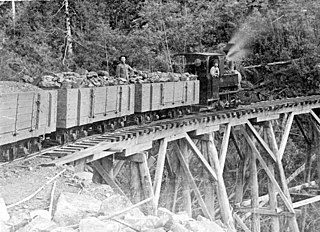
The Sandfly Colliery Tramway was a 20 km (12 mi), 2 ft narrow gauge tramway linking the Kaoota Mine to Margate, Tasmania. Constructed in 1905–06, the Tramway climbed 457 m (1,499 ft) above sea level and crossed ten bridges. After coal mining ceased the tramway was used to transport logs, fruit and passengers. The line was lifted and abandoned in 1922 after bushfires destroyed several bridges along the line. Currently, 6 km (3.7 mi) of the old track is used as cycling/walking tracks, while the remainder of the old line is on private property.
The Tasmanian Heritage Register is the statutory heritage register of the Australian state of Tasmania. It is defined as a list of areas currently identified as having historic cultural heritage importance to Tasmania as a whole. The Register is kept by the Tasmanian Heritage Council within the meaning of the Tasmanian Historic Cultural Heritage Act 1995. It encompasses in addition the Heritage Register of the Tasmanian branch of the National Trust of Australia, which was merged into the Tasmanian Heritage Register. The enforcement of the heritage's requirements is managed by Heritage Tasmania.
Longley is a rural residential locality in the local government area of Kingborough in the Hobart region of Tasmania. It is located about 13 kilometres (8.1 mi) west of the town of Kingston. The 2016 census has a population of 234 for the state suburb of Longley.
Lower Snug is a rural residential locality in the local government area (LGA) of Kingborough in the Hobart LGA region of Tasmania. The locality is about 15 kilometres (9.3 mi) south of the town of Kingston. The 2016 census recorded a population of 442 for the state suburb of Lower Snug. Lower Snug is also part of the Greater Hobart statistical area.
Taroona Beach is a popular beach destination along the River Derwent in Taroona, Hobart, Tasmania. The south facing beach looks directly out to Storm Bay and the Tasman Sea, with views of the Derwent estuary, the City of Clarence on the eastern shore, Opossum Bay, South Arm, the Alum Cliffs and northern tip of Bruny Island. Taroona Beach is situated between Hinsby Beach and Crayfish Point, home of the Fisheries and Aquaculture Centre for the Institute for Marine and Antarctic Studies. Taroona Beach contains a boat ramp and is backed by Taroona Park which contains bathroom facilities, a skate park, scout hall, the Taroona Tennis Club, and the Taroona Bowls and Community Club.
The Alum Cliffs are a section of cliffed coast facing the Derwent Estuary and Storm Bay along the suburbs of Taroona, Bonnet Hill, and Kingston Beach, Tasmania, Australia. Composed of Permian mudstone, the cliff formation stretches for 3.5 kilometres (2.2 mi) between Hinsby Beach and Tyndall Beach at Kingston Beach. The cliff face reaches heights of up to 30 metres (98 ft) above sea level and has vistas of the Derwent Estuary, Storm Bay, South Arm and Bruny Island.