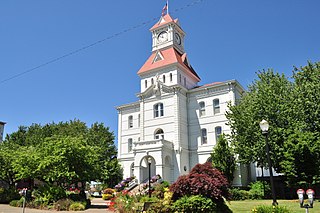
Benton County is one of the 36 counties in the U.S. state of Oregon. As of the 2023 census population estimates, the population was 99,355. Its county seat is Corvallis. The county was named after Thomas Hart Benton, a U.S. Senator who advocated American control over the Oregon Country. Benton County is designated as the Corvallis, OR Metropolitan Statistical Area, which is included in the Portland–Vancouver–Salem, OR–WA Combined Statistical Area. It is in the Willamette Valley.

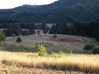
Marys River is a 40-mile (64 km) tributary of the Willamette River in the U.S. state of Oregon. From its source at the confluence of its east and west forks near Summit, it flows generally southeast from the Central Oregon Coast Range to Corvallis.

Springbrook is an unincorporated community within the city of Newberg, in Yamhill County, Oregon, United States. The community was originally named "Hoskins", after pioneer Cyrus E. Hoskins, who settled in the area. When a post office was established on June 30, 1893, the name was changed to Springbrook, since there was already a Hoskins, Oregon in Benton County. The post office closed in 1961.
Fort Hoskins was one of three "forts" built by the U.S. Army to monitor the Coastal Indian Reservation in Oregon Territory in the mid-19th century. The Fort Hoskins Site is listed on the National Register of Historic Places. Fort Hoskins was garrisoned by a number of companies of soldiers throughout its short existence, and future Union Civil War generals Christopher Columbus Augur and Phil Sheridan were stationed there.

Alsea is an unincorporated community in Benton County, in the U.S. state of Oregon. It is on Oregon Route 34 and the Alsea River. For statistical purposes, the United States Census Bureau has defined Alsea as a census-designated place (CDP). The census definition of the area may not precisely correspond to the local understanding of the area with the same name. As of the 2023 Census population estiamtes, the population was 220.

Wren is an unincorporated community in Benton County, Oregon, United States. It is located at the junction of U.S. Route 20 and Oregon Route 223 on the Marys River.

Bethel is an unincorporated community in Polk County, Oregon, United States. It sits at the base of the Eola Hills in Plum Valley. Bethel is considered a ghost town as the only remaining structure is a school, now serving as a church. The locale was named by the Rev. Glen O. Burnett for a Church of Christ in Missouri where he had served as pastor. Bethel is a common name for churches as it is a Hebrew word that means "house of god". After traveling with his family on the Oregon Trail, Burnett settled on a Donation Land Claim in 1846. Burnett later rode circuit to the surrounding area, preaching in nearby communities, including Rickreall.

Greenberry is an unincorporated community in Benton County, Oregon, United States. It is located on Oregon Route 99W about 8 miles south of Corvallis.

Horton is an unincorporated community in Lane County, Oregon, United States. It is about three miles northeast of Blachly, in the Lake Creek valley of the Central Oregon Coast Range.
Sparta is an unincorporated community in Baker County, Oregon, United States. It was named for Sparta, Illinois, by William H. Packwood, a prominent Oregon pioneer who visited the gold diggings at the Powder River there in 1871.
Harlan is an unincorporated community in Lincoln County, Oregon, United States, about 30 miles west of Corvallis. It is located in a valley of the Central Oregon Coast Range in the Siuslaw National Forest. The community's economy was once based on logging and sawmills. Cattle ranching is another mainstay of the local economy.
Saint Joseph is an unincorporated community in Yamhill County, Oregon, United States. It is located about two miles (3.2 km) west of Lafayette near Oregon Route 99W. The area is sometimes known as "St. Joe".
Tiernan is an unincorporated community in Lane County, Oregon, United States. It is about five miles west of Mapleton on Oregon Route 126 near the Siuslaw River and within the Siuslaw National Forest.
Pleasant Valley is an unincorporated community in Tillamook County, Oregon, United States. It is located about seven miles south of Tillamook, on U.S. Route 101.

The Valley and Siletz Railroad (VS) is a 40.6-mile (65.3 km) defunct railroad located in Polk and Benton counties in the U.S. state of Oregon.
Airlie is an unincorporated community in Polk County, Oregon, United States.
Crowley is an unincorporated community in Polk County, Oregon, United States. It is located east of Oregon Route 99W, about four miles north of Rickreall.
Suver is an unincorporated community in Polk County, Oregon, United States. It is located about 10 miles north of Corvallis and about 8 miles south of Monmouth, 1 mile east of Oregon Route 99W.
Rosedale is an unincorporated community in Marion County, Oregon, United States. It is located just south of Salem, in the Salem Hills. It is a part of the Salem Metropolitan Statistical Area.
Burlington is an unincorporated historic community Linn County, in the U.S. state of Oregon. It was located about a mile downriver from Peoria.

