Kingston Bridge, London

Last updated

Kingston Bridge
Kingston Bridge, London.jpg
Kingston Bridge from downstream at Kingston
Coordinates 51°24′40″N0°18′32″W / 51.41111°N 0.30889°W / 51.41111; -0.30889
Carries A308 road, Thames Path
Crosses River Thames
Locale Kingston upon Thames
Maintained by Kingston upon Thames London Borough Council
Characteristics
DesignArch
MaterialStone
Total length382 feet 0 inches (116.43 m)
Width79 feet 0 inches (24.08 m)
Height23 feet 11 inches (7.29 m) [1]
Longest span60 feet 0 inches (18.29 m)
No. of spans5
Piers in water4
History
Designer Edward Lapidge
Opened17 July 1828
Statistics
Daily traffic 50,000 vehicles
TollAbolished 1870
Listed Building – Grade II*
Official nameKingston Bridge
Designated30 July 1951
Reference no.1300232
Location
Kingston Bridge, London

Kingston Bridge is a road bridge at Kingston upon Thames in south west London, England, carrying the A308 across the River Thames. It joins the town centre of Kingston in the Royal Borough of Kingston upon Thames to Hampton Court Park, Bushy Park, and the village of Hampton Wick in the London Borough of Richmond upon Thames. In 2005 it was carrying approximately 50,000 vehicles per day with up to 2,000 vehicles per hour in each direction during peak times.

Contents

Kingston Bridge is on the reach above Teddington Lock and close to and downstream of the mouth of the Hogsmill River, a minor tributary of the Thames. The Thames Path crosses the river here and the bridge is the end point for the Thames Down Link long-distance footpath from Box Hill & Westhumble station. [2]

History

Until Putney Bridge was opened in 1729, Kingston Bridge was the only crossing of the river between London Bridge and Staines Bridge.

According to 16th-century antiquarian John Leland, the bridge existed in the centuries when Anglo-Saxon England existed (after Roman Britain and before 1066). He wrote "And yn the old tyme the commune saying ys that the bridge where the commun passage was over the Tamise was lower on the ryver then it is now. And when men began the new town in the Saxons tymes they toke from the very clive of Comeparke [cliff of Coombe Park] side to build on the Tamise side; and sette a new bridge hard by the same." [3] Other sources claim that the first Kingston Bridge was constructed in the 1190s. [4]

Leland refers to a contemporary bridge and to an older wooden bridge that had existed at Kingston since the 13th century. This was about 100 feet downstream of the present bridge: Old Bridge Street at Hampton Wick used to be matched by an Old Bridge Street on the Kingston side. [5] In 1318 the bridge was described as being in a dangerous condition. [6] The successive bridges contributed greatly to Kingston's success as a medieval market town.

Destroying or defending the few bridges of the Thames gave power – having no nearby bridges would particularly hinder mounted armies. The mediaeval timber bridge fell victim to destructions during the Wars of the Roses and Wyatt's rebellion. There are records of tolls being granted for various spells to pay for repairs to the bridge, but in 1567, Robert Hamond gave a sum to make it a free bridge 'forever'. [3] However, in spite of his endowments, for some years in the 18th century certain tolls were reimposed under the authority of the mayor and aldermen of the borough. The bridge was described in 1710 "The great Wooden Bridge hath 20 interstices: [note 1] two in the middle wide enough for barges...it had 22 pierres [piers] of Wood and had in the middle two fair Seates for Passengers to avoid Carts and to sit and enjoy the delightfull Prospect". [7]

The bridge's state of repair became increasingly problematic by the early 19th century. It had become increasingly dilapidated and its narrowness made passage difficult both for river and road traffic. Pressure mounted for it to be rebuilt but no agreement could be reached on who would be responsible or who would pay for it. The courts became involved in 1813 but were overtaken by events in January 1814, when part of the bridge collapsed due to a severe frost. The court ordered Kingston to repair the bridge from its own resources but a complete replacement was by that time clearly necessary. [8]

1828 bridge

A view of Kingston Bridge published in 1831. It has been widened twice since then. KingstonBridgeNEW AND COMPLETE HISTORY OF THE COUNTIES OF SURREY & SUSSEXauthorThomasAllenartistpossiblyNathaniel WHITTOCK.jpg
A view of Kingston Bridge published in 1831. It has been widened twice since then.

In 1825 Kingston Corporation notified the City of London Corporation Navigation Committee that it intended to build a new bridge. An Act of Parliament was passed in the same year to authorise construction. The corporation planned to erect a cast-iron bridge, and an architectural competition was held with a prize of 100 guineas. The winner was John Burges Watson, with a design for a bridge of three equal arches. However, concerns over the rising cost of iron led to the abandonment of the scheme, and it was decided instead to build a stone bridge in the classical style to a design by Edward Lapidge, the county surveyor. The first stone was laid by the Earl of Liverpool at a ceremony on 7 November 1825 [9] and the bridge was opened by the Duchess of Clarence (the future Queen Adelaide) on 17 July 1828. [8] The approach road to the east was named Clarence Street in her honour.

The new bridge, about 100 feet (30 m) upstream from its predecessor, [10] was built of Portland stone: comprising five elliptical arches. The centre arch enclosed a 60 foot (18 m) span, 19 feet (5.8 m) in height, and the side arches 56 feet (17 m) then 52 feet (16 m) in span progressively from the centre. The abutments were terminated by towers or bastions, and the whole surmounted by a cornice and balustrade, with galleries projecting over the pier; which gave a bold relief to the general elevation. The length of the bridge was 382 feet (116 m) by 27 feet (8.2 m) in width. The building contract was undertaken by Herbert for £26,800 (equivalent to £2,340,350in 2021), and extra work did not exceed £100, a rare occurrence in major public or private undertakings of that description at the time.

Kingston Bridge on the upstream side Kingston Bridge Over The Thames.jpg
Kingston Bridge on the upstream side

Following a lengthy campaign which came to a conclusion in 1869, the bridge became free from tolls on 12 March 1870, [8] and celebrations including a fireworks show were followed a few days later with the burning of the toll gates on Hampton Green. In March 1906, London United Tramways installed tramlines on Kingston Bridge, connecting the Surrey and Middlesex routes. [11] The increase in traffic and the narrowness of the road became a problem and in 1911 the engineering firm Mott & Hay was contracted to widen the bridge on the downstream side. [12] The work was undertaken between 1912 and 1914 with the carriageway increased from 25 feet (7.6 m) to 55 feet (17 m). A new façade of Portland stone was designed to replicate the features of the original. The bridge was reopened in October 1914. [8] In 1931, the trams were replaced by trolleybuses - before these were replaced by diesel buses in 1962. [13] Following construction of the Kingston Relief Road in the late 1980s, the bridge was widened again in 2000 to include two cycle lanes, larger pavements and a bus lane, from 55 feet (17 m) to 79 feet (24 m).

The bridge was given protection as a Grade II* listed structure in 1951. [14]

See also

Notes

  1. Interstices, also known as spans, are colloquially and, where arched, called arches.

Related Research Articles

<span class="mw-page-title-main">Kingston upon Thames</span> Town in South West London

Kingston upon Thames is a town in the Royal Borough of Kingston upon Thames, southwest London, England. It is situated on the River Thames and 10 miles (16 km) southwest of Charing Cross. It is notable as the ancient market town in which Saxon kings were crowned and today is the administrative centre of the Royal Borough of Kingston upon Thames.

<span class="mw-page-title-main">Staines-upon-Thames</span> Town in Surrey, England

Staines-upon-Thames is a market town in northwest Surrey, England, around 17 miles west of central London. It is in the Borough of Spelthorne, at the confluence of the River Thames and Colne. Historically part of Middlesex, the town was transferred to Surrey in 1965. Staines is close to Heathrow Airport and is linked to the national motorway network by the M25 and M3.

<span class="mw-page-title-main">Blackfriars Bridge</span> Bridge over the River Thames in London

Blackfriars Bridge is a road and foot traffic bridge over the River Thames in London, between Waterloo Bridge and Blackfriars Railway Bridge, carrying the A201 road. The north end is in the City of London near the Inns of Court and Temple Church, along with Blackfriars station. The south end is in the London Borough of Southwark, near the Tate Modern art gallery and the Oxo Tower. Opened in the 1860s, it replaced an earlier bridge from the 1760s.

<span class="mw-page-title-main">Hampton, London</span> Human settlement in England

Hampton is a suburban area on the north bank of the River Thames, in the London Borough of Richmond upon Thames, England, in the historic county of Middlesex. Hampton is bounded by Bushy Park to the east, the suburbs of Hampton Hill and Fulwell to the north, green belt to the west, and the Thames to the south.

<span class="mw-page-title-main">Vauxhall Bridge</span> Arch bridge in central London

Vauxhall Bridge is a Grade II* listed steel and granite deck arch bridge in central London. It crosses the River Thames in a southeast–northwest direction between Vauxhall on the south bank and Pimlico on the north bank. Opened in 1906, it replaced an earlier bridge, originally known as Regent Bridge but later renamed Vauxhall Bridge, built between 1809 and 1816 as part of a scheme for redeveloping the south bank of the Thames. The bridge was built at a location in the river previously served by a ferry.

<span class="mw-page-title-main">Battersea Bridge</span> Bridge over the River Thames in London

Battersea Bridge is a five-span arch bridge with cast-iron girders and granite piers crossing the River Thames in London, England. It is situated on a sharp bend in the river, and links Battersea south of the river with Chelsea to the north. The bridge replaced a ferry service that had operated near the site since at least the middle of the 16th century.

<span class="mw-page-title-main">Westminster Bridge</span> Bridge over the River Thames in London

Westminster Bridge is a road-and-foot-traffic bridge over the River Thames in London, linking Westminster on the west side and Lambeth on the east side.

<span class="mw-page-title-main">Richmond Lock and Footbridge</span> Lock and pedestrian bridges in London, England

Richmond Lock and Footbridge is a lock, rising and falling low-tide barrage integrating controlled sluices and pair of pedestrian bridges on the River Thames in southwest London, England, and is a Grade II* listed structure. It is the furthest downstream of the forty-five Thames locks and the only one owned and operated by the Port of London Authority. It was opened in 1894 and is north-west of the centre of Richmond in a semi-urban part of southwest London. Downstream are Syon Park and Kew Gardens on opposite banks. It connects the promenade at Richmond with the neighbouring district of St. Margarets on the west bank during the day and is closed at night to pedestrians – after 19:30 GMT or after 21:30 when BST is in use. At high tide the sluice gates are raised and partly hidden behind metal arches forming twin footbridges.

<span class="mw-page-title-main">Teddington Lock</span> Series of locks on the River Thames in London

Teddington Lock is a complex of three locks and a weir on the River Thames between Ham and Teddington in the London Borough of Richmond upon Thames, England. Historically in Middlesex, it was first built in 1810.

<span class="mw-page-title-main">Hampton Wick</span> Human settlement in England

Hampton Wick is a Thamesside area of the London Borough of Richmond upon Thames, England, contiguous with Teddington, Kingston upon Thames and Bushy Park.

<span class="mw-page-title-main">Trowlock Island</span> Island in the River Thames

Trowlock Island is a residential island in the River Thames 450 metres (490 yd) upstream of Teddington Lock on the non-tidal Kingston reach less than 10 metres from the northern bank, in the London Borough of Richmond upon Thames, England.

Richmond Bridge is an 18th-century stone arch bridge that crosses the River Thames at Richmond, connecting the two halves of the present-day London Borough of Richmond upon Thames. It was designed by James Paine and Kenton Couse.

<span class="mw-page-title-main">Molesey</span> District in Surrey, England

Molesey is a suburban district comprising two villages, East Molesey and West Molesey, in the Borough of Elmbridge, Surrey, England, and is situated on the south bank of the River Thames.

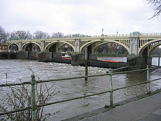
Chiswick Bridge is a reinforced concrete deck arch bridge over the River Thames in West London. It is one of three bridges opened in 1933 as part of an ambitious scheme to relieve traffic congestion west of London. The structure carries the A316 road between Chiswick on the north bank of the Thames and Mortlake on the south bank.

<span class="mw-page-title-main">Hampton Court Bridge</span> Bridge over the Thames linking London with Surrey, England

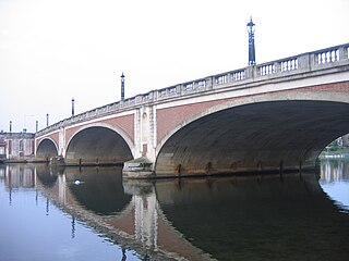
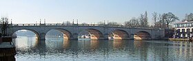
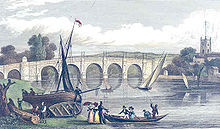
Hampton Court Bridge is a Grade II listed bridge that crosses the River Thames in England approximately north–south between Hampton, London and East Molesey, Surrey, carrying the A309. It is the upper of two road bridges on the reach above Teddington Lock and downstream of Molesey Lock.

<span class="mw-page-title-main">A308 road</span> Road in England

The A308 is a road in England in two parts. The first part runs from Central London to Putney Bridge. The second part runs from just beyond Putney Heath to Bisham, Berkshire. It traces four, roughly straight lines, to stay no more than 3 miles (4.8 km) from the Thames. It is a dual carriageway where it is furthest from that river, in Spelthorne, Surrey and forms one of the motorway spurs to the large town of Maidenhead. Other key settlements served are Fulham, Kingston (London), Staines upon Thames, Windsor and a minor approach to Marlow

<span class="mw-page-title-main">Chertsey Bridge</span> Bridge in Chertsey

Chertsey Bridge is a road bridge across the River Thames in England, connecting Chertsey to low-lying riverside meadows in Laleham, Surrey. It is 550 yards (500 m) downstream from the M3 motorway bridge over the Thames and is close to Chertsey Lock on the reach above Shepperton Lock. The bridge is a seven-arch tied arch white stone bridge built 1783–85 and is a Grade II* listed building. It has a weight restriction of 18 tonnes for LGVs.

<span class="mw-page-title-main">Thames Ditton Island</span>

Three river islands (aits) form a linear group, close to the junction of the two main old streets of Thames Ditton village, in the River Thames in a corner of modern Surrey, on the Kingston reach above Teddington Lock. Thames Ditton Island, the dominant ait, is 350 yards (320 m) long and has 48 houses with gardens ; Boyle Farm Island has one house; Swan Island, between the two, is the smallest.

<span class="mw-page-title-main">Staines Bridge</span> Bridge across the River Thames in England

Staines Bridge is a road bridge running in a south-west to north-east direction across the River Thames in Surrey. It is on the modern A308 road and links the boroughs of Spelthorne and Runnymede at Staines-upon-Thames and Egham Hythe. The bridge is Grade II listed.

<span class="mw-page-title-main">Walton Bridge</span> Bridge in Walton on Thames and Shepperton, Surrey

Walton Bridge is a road bridge across the River Thames in England, carrying the A244 between Walton-on-Thames and Shepperton, crossing the Thames on the reach between Sunbury Lock and Shepperton Lock.

References

Citations

  1. River Thames Alliance. Bridge heights on the River Thames.
  2. "Thames Down Link" (PDF). Surrey County Council. Archived from the original (PDF) on 22 June 2011. Retrieved 6 January 2011.
  3. 1 2 Kingston upon Thames, The Environs of London: volume 1: County of Surrey (1792), pp. 212–256. Date accessed: 30 September 2008
  4. "Kingston's History". Guided walks of Historic Kingston. Kingston Tour Guides. Archived from the original on 7 March 2014. Retrieved 27 July 2013.
  5. Thacker 1968 , p. 455
  6. Thacker, Fred S. (1968) [reprint of 1920 edition]. The Thames Highway. Vol. 2, Locks and Weirs. David & Charles. p. 454.
  7. Thacker 1968 , p. 456. Original quote from A Perambulation of the County of Surrey by John Aubrey pp.45–46.
  8. 1 2 3 4 Croad, Stephen (2003). Liquid History: The Thames Through Time. Batsford Books. p. 25. ISBN   978-0-7134-8834-0.
  9. "New bridge, Kingston-upon-Thames". The New Monthly Magazine and Universal Register. 15: 559–6. 1 December 1825. Retrieved 20 July 2011.
  10. "Old Kingston Bridge and Undercroft" (PDF). Archived from the original (PDF) on 12 November 2011. Retrieved 20 July 2011.
  11. "Trams, The trams came to Middlesex at the start of the 20th century - Twickenham Museum". www.twickenham-museum.org.uk. Retrieved 16 August 2021.
  12. "Basil Mott - Graces Guide". www.gracesguide.co.uk. Retrieved 16 August 2021.
  13. "London United Tramway Car 320, Kingston Bridge". www.tramwayinfo.com. Retrieved 16 August 2021.
  14. Historic England (30 July 1951). "Kingston Bridge (1300232)". National Heritage List for England . Retrieved 29 July 2020.

Sources

  • Kingston New Bridge, in The Mirror of Literature, Amusement, and Instruction Volume XII., No. 324, 26 July 1828
  • Kingston Bridge at Structurae
Next crossing upstream River Thames Next crossing downstream
Hampton Court Bridge (road)Kingston Bridge, London
Grid reference TQ177693
Kingston Railway Bridge (rail)
Next crossing upstream Thames Path Next crossing downstream
northern bank
Hampton Court Bridge
Kingston Bridge, Londonsouthern bank
Teddington Lock Footbridge