Kirwin National Wildlife Refuge

Last updated
Kirwin National Wildlife Refuge
IUCN category IV (habitat/species management area)
Kirwin Prairie Flowers (7468776398).jpg
Usa edcp relief location map.png
Red pog.svg
Map of the United States
Location Phillips County, Kansas, United States
Nearest city Kirwin, Kansas
Coordinates 39°38′30″N99°11′00″W / 39.64167°N 99.18333°W / 39.64167; -99.18333 Coordinates: 39°38′30″N99°11′00″W / 39.64167°N 99.18333°W / 39.64167; -99.18333
Area 10,778 acres (43.62 km2)
Established 1954
Governing body U.S. Fish and Wildlife Service
Website Kirwin National Wildlife Refuge

Kirwin National Wildlife Refuge is a National Wildlife Refuge of the United States located in Kansas. It was established in 1954 for the conservation and management of wildlife resources, particularly migratory birds. The Kirwin Dam was built in the early 1950s near Kirwin, Kansas, and the reservoir created in the process provides water to the refuge.

National Wildlife Refuge type of federal conservation area in the United States

National Wildlife RefugeSystem is a designation for certain protected areas of the United States managed by the United States Fish and Wildlife Service. The National Wildlife Refuge System is the system of public lands and waters set aside to conserve America's fish, wildlife, and plants. Since President Theodore Roosevelt designated Florida's Pelican Island National Wildlife Refuge as the first wildlife refuge in 1903, the system has grown to over 562 national wildlife refuges and 38 wetland management districts encompassing more than 150,000,000 acres (607,028 km2).

United States Federal republic in North America

The United States of America (USA), commonly known as the United States or America, is a country composed of 50 states, a federal district, five major self-governing territories, and various possessions. At 3.8 million square miles, the United States is the world's third or fourth largest country by total area and is slightly smaller than the entire continent of Europe's 3.9 million square miles. With a population of over 327 million people, the U.S. is the third most populous country. The capital is Washington, D.C., and the largest city by population is New York City. Forty-eight states and the capital's federal district are contiguous in North America between Canada and Mexico. The State of Alaska is in the northwest corner of North America, bordered by Canada to the east and across the Bering Strait from Russia to the west. The State of Hawaii is an archipelago in the mid-Pacific Ocean. The U.S. territories are scattered about the Pacific Ocean and the Caribbean Sea, stretching across nine official time zones. The extremely diverse geography, climate, and wildlife of the United States make it one of the world's 17 megadiverse countries.

Kansas State of the United States of America

Kansas is a U.S. state in the Midwestern United States. Its capital is Topeka and its largest city is Wichita, with its most populated county being Johnson County. Kansas is bordered by Nebraska on the north; Missouri on the east; Oklahoma on the south; and Colorado on the west. Kansas is named after the Kansas River, which in turn was named after the Kansa Native Americans who lived along it banks. The tribe's name is often said to mean "people of the (south) wind" although this was probably not the term's original meaning. For thousands of years, what is now Kansas was home to numerous and diverse Native American tribes. Tribes in the eastern part of the state generally lived in villages along the river valleys. Tribes in the western part of the state were semi-nomadic and hunted large herds of bison.

Contents

Ecology

The refuge is located along the North Fork of the Solomon River in the region where tallgrass prairie meets shortgrass prairie on the Great Plains. This merging of grassland types brings a diversity of flora and fauna to the area. Other habitat types include wetlands and cropland. More than 300 species of birds, mammals, reptiles, amphibians, and fish inhabit the refuge.

Solomon River river in the United States of America

The Solomon River, often referred to as the "Solomon Fork", is a 184-mile-long (296 km) river in the central Great Plains of North America. The entire length of the river lies in the U.S. state of Kansas. It is a tributary of the Smoky Hill River.

Tallgrass prairie ecosystem native to central North America

The Tallgrass prairie is an ecosystem native to central North America. Natural and anthropogenic fire, as well as grazing by large mammals, were historically agents of periodic disturbance, which regulates tree encroachment, recycles nutrients to the soil, and catalyzes some seed dispersal and germination processes. Prior to widespread use of the steel plow, which enabled conversion to agricultural land use, tallgrass prairies expanded throughout the American Midwest and smaller portions of southern central Canada, from the transitional ecotones out of eastern North American forests, west to a climatic threshold based on precipitation and soils, to the southern reaches of the Flint Hills in Oklahoma, to a transition into forest in Manitoba.

Shortgrass prairie ecosystem in the Great Plains of North America

The shortgrass prairie is an ecosystem located in the Great Plains of North America. The prairie includes lands to the west as far as the eastern foothills of the Rocky Mountains and extends east as far as Nebraska and north into Saskatchewan. The prairie stretches through parts of Alberta, Wyoming, Montana, North Dakota, South Dakota, and Kansas, and passes south through the high plains of Colorado, Oklahoma, Texas, and New Mexico.

Four federally listed and two state-listed threatened and endangered species of birds can be observed. Twenty-eight other birds of conservation concern use the refuge during their annual migrations, and nine nest there. In ideal conditions, up to a million ducks and geese aggregate there. Large numbers of shorebirds migrate through the refuge in late summer. Hundreds of great blue herons and double-crested cormorants nest in the flooded timber, and interior least terns nest when the water is lower. Populations of greater prairie chickens and black-tailed prairie dogs occur on the refuge.

Threatened species

Threatened species are any species which are vulnerable to endangerment in the near future. Species that are threatened are sometimes characterised by the population dynamics measure of critical depensation, a mathematical measure of biomass related to population growth rate. This quantitative metric is one method of evaluating the degree of endangerment.

Endangered species Species of organisms facing a very high risk of extinction

An endangered species is a species which has been categorized as very likely to become extinct. Endangered (EN), as categorized by the International Union for Conservation of Nature (IUCN) Red List, is the second most severe conservation status for wild populations in the IUCN's schema after Critically Endangered (CR).

Duck common name for many species in the bird family Anatidae

Duck is the common name for a large number of species in the waterfowl family Anatidae which also includes swans and geese. Ducks are divided among several subfamilies in the family Anatidae; they do not represent a monophyletic group but a form taxon, since swans and geese are not considered ducks. Ducks are mostly aquatic birds, mostly smaller than the swans and geese, and may be found in both fresh water and sea water.

Recreation

Recreational activities include car tours, wildlife observation, boating, fishing, hiking, hunting, and educational programs. There is a visitor's center and a museum.

Boating leisure activity involving boats

Boating is the leisurely activity of travelling by boat, or the recreational use of a boat whether powerboats, sailboats, or man-powered vessels, focused on the travel itself, as well as sports activities, such as fishing or waterskiing. It is a popular activity, and there are millions of boaters worldwide.

Fishing Activity of trying to catch fish

Fishing is the activity of trying to catch fish. Fish are normally caught in the wild. Techniques for catching fish include hand gathering, spearing, netting, angling and trapping. “Fishing” may include catching aquatic animals other than fish, such as molluscs, cephalopods, crustaceans, and echinoderms. The term is not normally applied to catching farmed fish, or to aquatic mammals, such as whales where the term whaling is more appropriate. In addition to being caught to be eaten, fish are caught as recreational pastimes. Fishing tournaments are held, and caught fish are sometimes kept as preserved or living trophies. When bioblitzes occur, fish are typically caught, identified, and then released.

Hiking walking as a hobby, sport, or leisure activity

Hiking is the preferred term, in Canada and the United States, for a long, vigorous walk, usually on trails (footpaths), in the countryside, while the word walking is used for shorter, particularly urban walks. On the other hand, in the United Kingdom, and the Republic of Ireland, the word "walking" is acceptable to describe all forms of walking, whether it is a walk in the park or backpacking in the Alps. The word hiking is also often used in the UK, along with rambling, hillwalking, and fell walking. The term bushwalking is endemic to Australia, having been adopted by the Sydney Bush Walkers club in 1927. In New Zealand a long, vigorous walk or hike is called tramping. It is a popular activity with numerous hiking organizations worldwide, and studies suggest that all forms of walking have health benefits.

PD-icon.svg This article incorporates  public domain material from websites or documents ofthe United States Fish and Wildlife Service .

United States Fish and Wildlife Service US Federal Government agency

The United States Fish and Wildlife Service is an agency of the US Federal Government within the US Department of the Interior dedicated to the management of fish, wildlife, and natural habitats. The mission of the agency is "working with others to conserve, protect, and enhance fish, wildlife, plants and their habitats for the continuing benefit of the American people."


Related Research Articles

Quivira National Wildlife Refuge

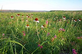
Quivira National Wildlife Refuge is located in south central Kansas near the town of Stafford. It lies mostly in northeastern Stafford County, but small parts extend into southwestern Rice and northwestern Reno Counties. Its proximity to the Central Flyway migration route and the salt marshes on the refuge combine to endow the refuge with a large variety of birds. Many of these birds are uncommon in other parts of Kansas or even the central part of the continent.

Marais des Cygnes National Wildlife Refuge

Marais des Cygnes National Wildlife Refuge (NWR) is located in Linn County, Kansas along the Marais des Cygnes River. The 7,500 acre (30 km2) Refuge was established in 1992 to protect one of the northwestern-most examples of bottomland hardwood forest in the United States as well as the largest contiguous tract of bottomland hardwood forest in Kansas. Marais des Cygnes means "marsh of swans" in French.

Missisquoi National Wildlife Refuge

Missisquoi National Wildlife Refuge is a National Wildlife Refuge located in the eastern shore of Lake Champlain in the U.S. state of Vermont. The refuge is in Franklin County in the northwest corner of the state near the International Boundary with Canada. It is the only National Wildlife Refuge located entirely in Vermont, and is administered by the United States Fish and Wildlife Service.

Arapaho National Wildlife Refuge

The Arapaho National Wildlife Refuge is a United States National Wildlife Refuge located in north central Colorado. It is one of over 560 national wildlife refuges which manages and protects natural resources for future generations. The refuge is located in North Park in central Jackson County south of the town of Walden. The refuge was established in 1967 to furnish waterfowl with a suitable place to nest and rear their young. It was created in part to offset losses of nesting habitat in the prairie wetland region of the Midwest. It is located in the valley of the Illinois River, a tributary of the North Platte River. It is administered by the United States Fish and Wildlife Service.

Benton Lake National Wildlife Refuge

Benton Lake National Wildlife Refuge is a 12,459-acre (5,042 ha) National Wildlife Refuge (NWR) in the central part of the U.S. state of Montana. It lies in northern Cascade County, 12 mi (19 km) north of the city of Great Falls, Montana. Benton Lake NWR includes shortgrass prairie and seasonal wetlands, and is nearly surrounded by the Highwood Mountains to the east, Big Belt Mountains to the south, and the Rocky Mountains to the west. Benton Lake NWR is on the western edge of the northern Great Plains and much of the shallow lake is a 6,000-acre (2,400 ha) wetland.

Bowdoin National Wildlife Refuge

Bowdoin National Wildlife Refuge is a 15,551-acre (6,293 ha) National Wildlife Refuge (NWR) located in the north-central region of the U.S. state of Montana. The refuge is 7 mi (11 km) northeast of Malta, Montana in the Milk River Valley and is managed by the U.S. Fish and Wildlife Service.

North Platte National Wildlife Refuge

North Platte National Wildlife Refuge is located in the U.S. state of Nebraska and includes 5,047 acres (20.42 km2). Managed by the U.S. Fish and Wildlife Service, the refuge is broken into four separate sections that are superimposed on U.S. Bureau of Reclamation–managed lakes and reservoirs. Together with the Crescent Lake National Wildlife Refuge, the two refuges form the Crescent Lake National Wildlife Refuge Complex.

Lacreek National Wildlife Refuge

Lacreek National Wildlife Refuge is a National Wildlife Refuge of the United States located in South Dakota. It covers 16,410 acres (66.4 km2) and is managed by the United States Fish and Wildlife Service.

Erie National Wildlife Refuge

The Erie National Wildlife Refuge is an 8,777-acre (3,552 ha) National Wildlife Refuge located in Crawford County, Pennsylvania. Named after the Erie tribe, it was established to provide waterfowl and other migratory birds with nesting, feeding, brooding, and resting habitat.

Baskett Slough National Wildlife Refuge protected area

Baskett Slough National Wildlife Refuge is located in northwestern Oregon, 10 miles (16 km) west of Salem in Polk County. Situated in open farmland near the eastern foothills of the Oregon Coast Range with the broad Willamette Valley and the Cascade Range to the east, elevations range from 185 to 414 feet MSL. The Willamette Valley, with its mild, rainy winter climate, is an ideal environment for wintering waterfowl. The valley was once a rich mix of wildlife habitats with extensive wetlands, meandering stream channels and vast seasonal marshes. Today, the valley is a mix of farmland and growing cities, with few areas remaining for wildlife. The Refuge consists of 1,173 acres (4.75 km²) of cropland, which provide forage for wintering geese, 300 acres (1.2 km²) of forests, 550 acres (2.2 km²) of grasslands, and 500 acres (2.0 km²) of shallow water seasonal wetlands and 35 acres (0.14 km²) of permanent open water. In 1965, Baskett Slough National Wildlife Refuge was created to help ensure some of the original habitat remained for species preservation. The refuge is managed by the U.S. Fish and Wildlife Service, an agency of the U.S. Department of the Interior.

Lake Woodruff National Wildlife Refuge

The Lake Woodruff National Wildlife Refuge is part of the United States National Wildlife Refuge System, located in north central Florida, twenty-five miles west of Daytona Beach, off U.S. Highway 17 in DeLeon Springs.

Audubon National Wildlife Refuge

Audubon National Wildlife Refuge is a 14,739-acre (5,965 ha) National Wildlife Refuge in the U.S. state of North Dakota. The refuge is managed by the U.S. Fish and Wildlife Service and is the centerpiece of the Audubon National Wildlife Refuge Complex, which includes numerous other refuges in the region. Originally designated as the Snake Creek National Wildlife Refuge in 1955, the refuge was renamed in 1967 in honor of the artist and naturalist John James Audubon. Most of the refuge area is a lake known as Audubon Lake which is managed by the U.S. Army Corps of Engineers.

Lake Ilo National Wildlife Refuge

Lake Ilo National Wildlife Refuge (NWR) is located in the U.S. state of North Dakota and is managed from Audubon National Wildlife Refuge by the U.S. Fish and Wildlife Service. The refuge consists of Lake Ilo, surrounding wetlands and some upland range, providing habitat for hundreds of species of birds, and numerous fish and mammal species. An average of over 16 inches (40 cm) of precipitation falls annually, supporting a prairie ecosystem.

Glacial Ridge National Wildlife Refuge

Glacial Ridge National Wildlife Refuge was created on October 12, 2004, the 545th National Wildlife Refuge in the United States. Its creation was the result of cooperation between at least 30 agencies or governmental entities. The creation of the refuge was spearheaded by The Nature Conservancy, and the initial endowment of 2,300 acres (9.3 km2) of land was donated by the Conservancy. In light of its planned final size of 37,756 acres (153 km2), it is described by the US Fish and Wildlife Service as "the largest tallgrass prairie and wetland restoration project in U.S. history."

Black Bayou Lake National Wildlife Refuge

Black Bayou Lake National Wildlife Refuge is one of five refuges managed in the North Louisiana Refuge Complex and one of 545 refuges in the National Wildlife Refuge System. It was established in 1997 through a unique partnership with the city of Monroe, Louisiana. The U.S. Fish and Wildlife Service has a free 99-year lease to manage the city-owned lake.

Handy Brake National Wildlife Refuge

Handy Brake National Wildlife Refuge is located just north of Bastrop, Louisiana in Morehouse Parish, north central Louisiana. The refuge was established in 1988 with the southeast's first fee title transfer of a Farmer's Home Administration tract to the U.S. Fish and Wildlife Service. A free lease of 38 acres (150,000 m2) from International Paper increased the refuge to the current 501 acres (2.03 km2).

Shell Keys National Wildlife Refuge

Shell Keys National Wildlife Refuge is located in the offshore waters to the west of the Atchafalaya River Delta, south of Marsh Island Wildlife Management Area. It was established in 1907 and is one of the oldest refuges in the National Wildlife Refuge System.

Hagerman National Wildlife Refuge

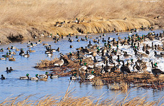
Hagerman National Wildlife Refuge (HNWR), a haven for migratory birds and other wildlife, lies in northwestern Grayson County, Texas, on the Big Mineral Arm of Lake Texoma, on the Red River between Oklahoma and Texas. This National Wildlife Refuge is made up of water, marsh, and upland habitat. Visitors can hike, observe wildlife, hunt, and fish throughout the year.

Summer Lake Wildlife Area

The Summer Lake Wildlife Area is a 29.6-square-mile (77 km2) wildlife refuge located on the northwestern edge of the Great Basin drainage in south-central Oregon. It is administered by the Oregon Department of Fish and Wildlife. The refuge is an important stop for waterfowl traveling along the Pacific Flyway during their spring and fall migrations. The Summer Lake Wildlife Area also provides habitat for shorebirds and other bird species as well as wide variety of mammals and several fish species. The Ana River supplies the water for the refuge wetlands.

Kirwin Reservoir

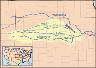
Kirwin Reservoir is a reservoir in Phillips County, Kansas, United States. It is located next to the city of Kirwin in northern Kansas. The U.S. Bureau of Reclamation built it and continues to operate it for the purposes of flood control and area irrigation. The Kirwin National Wildlife Refuge lies on its shores.