Klamath, California

Last updated

Klamath, California
Del Norte County California Incorporated and Unincorporated areas Klamath Highlighted.svg
Location in Del Norte County and the state of California
Usa edcp location map.svg
Red pog.svg
Klamath, California
Location in the United States
Coordinates: 41°31′35″N124°02′18″W / 41.52639°N 124.03833°W / 41.52639; -124.03833
Country United States
State California
County Del Norte
Area
[1]
  Total12.541 sq mi (32.480 km2)
  Land12.541 sq mi (32.480 km2)
  Water0 sq mi (0 km2)  0%
Elevation
30 ft (9 m)
Population
 (2020)
  Total1,088
  Density87/sq mi (33/km2)
Time zone UTC-8 (Pacific (PST))
  Summer (DST) UTC-7 (PDT)
ZIP code
95548
Area code 707
FIPS code 06-38702
GNIS feature ID0277534
U.S. Geological Survey Geographic Names Information System: Klamath, California

Klamath (Tolowa: Taa-chit) [2] is an unincorporated community in Del Norte County, California, situated on US Route 101 inland from the mouth of the Klamath River. The population of Klamath is 632 based on US Census estimates, down from 779 recorded in the 2010 US census. For statistical purposes, the United States Census Bureau has defined Klamath as a census-designated place (CDP). Klamath is at an elevation of 30 feet (9 m). Klamath is located within the Yurok Indian Reservation.

Contents

The original town center was destroyed by the 1964 Flood. Streets and sidewalks of this original site, west of US 101 and the current site of the town's core, remain visible.

Geography

According to the United States Census Bureau, the CDP has a total area of 12.5 square miles (32 km2), all of it land.

Climate

The region experiences warm (but not hot) and dry summers, with no average monthly temperatures above 71.6 °F (22.0 °C). According to the Köppen Climate Classification system, Klamath has a warm-summer Mediterranean climate, abbreviated "Csb" on climate maps. [3]

Climate data for Klamath
MonthJanFebMarAprMayJunJulAugSepOctNovDecYear
Record high °F (°C)75
(24)
80
(27)
81
(27)
86
(30)
91
(33)
98
(37)
89
(32)
93
(34)
95
(35)
90
(32)
78
(26)
72
(22)
98
(37)
Average high °F (°C)54.4
(12.4)
56.3
(13.5)
56.7
(13.7)
58.5
(14.7)
61.8
(16.6)
64.8
(18.2)
66.3
(19.1)
66.7
(19.3)
67.2
(19.6)
64.2
(17.9)
58.6
(14.8)
54.6
(12.6)
60.8
(16.0)
Daily mean °F (°C)46.4
(8.0)
47.9
(8.8)
48.4
(9.1)
50.2
(10.1)
53.6
(12.0)
57.7
(14.3)
58.9
(14.9)
59.4
(15.2)
58.5
(14.7)
55.1
(12.8)
50.3
(10.2)
46.6
(8.1)
52.7
(11.5)
Average low °F (°C)38.4
(3.6)
39.6
(4.2)
40.1
(4.5)
42
(6)
45.4
(7.4)
49.1
(9.5)
51.6
(10.9)
52.2
(11.2)
49.8
(9.9)
46
(8)
42.1
(5.6)
38.7
(3.7)
44.6
(7.0)
Record low °F (°C)18
(−8)
19
(−7)
24
(−4)
27
(−3)
24
(−4)
33
(1)
34
(1)
36
(2)
24
(−4)
28
(−2)
22
(−6)
16
(−9)
16
(−9)
Average precipitation inches (mm)13.86
(352)
10.79
(274)
10.51
(267)
5.72
(145)
3.63
(92)
1.42
(36)
0.32
(8.1)
0.73
(19)
1.71
(43)
5.66
(144)
11.68
(297)
14.05
(357)
80.09
(2,034)
Average snowfall inches (cm)0.4
(1.0)
0.4
(1.0)
0.1
(0.25)
0
(0)
0
(0)
0
(0)
0
(0)
0
(0)
0
(0)
0
(0)
0
(0)
0.1
(0.25)
1.1
(2.8)
Average precipitation days171516128522481517121
Source: [4]
Babe the Blue Ox and Trees of Mystery in Klamath Klamath-CA-Babe.jpg
Babe the Blue Ox and Trees of Mystery in Klamath
KHV No. 10, a 3-truck Heisler locomotive on the Klamath & Hoppow Valley Railroad, 1972 KHV 10 Aug 1972 Pickering 10xRP - Flickr - drewj1946.jpg
KHV No. 10, a 3-truck Heisler locomotive on the Klamath & Hoppow Valley Railroad, 1972

Demographics

2010

At the 2010 census Klamath had a population of 779. The population density was 62.1 inhabitants per square mile (24.0/km2). The racial makeup of Klamath was 379 (48.7%) White, 1 (0.1%) African American, 325 (41.7%) Native American, 3 (0.4%) Asian, 0 (0.0%) Pacific Islander, 5 (0.6%) from other races, and 66 (8.5%) from two or more races. Hispanic or Latino of any race were 90 people (11.6%). [6]

The census reported that 775 people (99.5% of the population) lived in households, 4 (0.5%) lived in non-institutionalized group quarters, and no one was institutionalized.

There were 307 households, 83 (27.0%) had children under the age of 18 living in them, 107 (34.9%) were opposite-sex married couples living together, 37 (12.1%) had a female householder with no husband present, 30 (9.8%) had a male householder with no wife present. There were 38 (12.4%) unmarried opposite-sex partnerships, and 5 (1.6%) same-sex married couples or partnerships. 94 households (30.6%) were one person and 35 (11.4%) had someone living alone who was 65 or older. The average household size was 2.52. There were 174 families (56.7% of households); the average family size was 3.20.

The age distribution was 183 people (23.5%) under the age of 18, 53 people (6.8%) aged 18 to 24, 168 people (21.6%) aged 25 to 44, 231 people (29.7%) aged 45 to 64, and 144 people (18.5%) who were 65 or older. The median age was 43.1 years. For every 100 females, there were 107.2 males. For every 100 females age 18 and over, there were 109.9 males.

There were 406 housing units at an average density of 32.4 per square mile (12.5/km2),of which 307 were occupied, 173 (56.4%) by the owners and 134 (43.6%) by renters. The homeowner vacancy rate was 3.9%; the rental vacancy rate was 8.8%. 398 people (51.1% of the population) lived in owner-occupied housing units and 377 people (48.4%) lived in rental housing units.

2000

At the 2000 census there were 651 people, 264 households, and 177 families in the CDP. The population density was 51.9 inhabitants per square mile (20.0/km2). There were 365 housing units at an average density of 29.1 per square mile (11.2/km2). The racial makeup of the CDP was 58.37% White, 34.25% Native American, 0.77% Asian, 2.15% from other races, and 4.45% from two or more races. 5.53% of the population were Hispanic or Latino of any race. [7] Of the 264 households 25.8% had children under the age of 18 living with them, 48.5% were married couples living together, 11.4% had a female householder with no husband present, and 32.6% were non-families. 27.3% of households were one person and 10.2% were one person aged 65 or older. The average household size was 2.39 and the average family size was 2.83.

The age distribution was 24.4% under the age of 18, 8.6% from 18 to 24, 21.8% from 25 to 44, 24.4% from 45 to 64, and 20.7% 65 or older. The median age was 41 years. For every 100 females, there were 110.7 males. For every 100 females age 18 and over, there were 104.1 males.

The median household income was $29,231 and the median family income was $29,417. Males had a median income of $24,750 versus $22,500 for females. The per capita income for the CDP was $13,660. About 11.2% of families and 15.2% of the population were below the poverty line, including 13.5% of those under age 18 and 7.9% of those age 65 or over.

Economy

Salmon fishing was a major component of the local economy. As of late, fish stocks are in decline due to political feuds with upstream agribusiness water users in the Klamath Falls area.

Arts and culture

Klamath has a 35-foot-tall (10 m) statue of Babe the Blue Ox, the legendary sidekick of Paul Bunyan, the famous mythical lumberjack, at Trees of Mystery. On November 20, 2007, the head of the statue fell off; it has since been repaired. [8]

Klamath is home to one of three California redwood trees that can be driven through. [9]

Government

In the state legislature, Klamath is in the 2nd Senate District , represented by Democrat Mike McGuire, [10] and the 2nd Assembly District , represented by Democrat Jim Wood. [11]

Federally, Klamath is in California's 2nd congressional district , represented by Democrat Jared Huffman. [12]

Notable people

See also

Related Research Articles

<span class="mw-page-title-main">Palermo, California</span> Census-designated place in California, United States

Palermo is a census-designated place (CDP) in Butte County, California, United States. The population was 5,382 at the 2010 census, down from 5,720 at the 2000 census.

<span class="mw-page-title-main">Auberry, California</span> Census-designated place in California, United States

Auberry is a census-designated place (CDP) in Fresno County, California, United States. The population was 2,369 at the 2010 census, up from 2,053 at the 2000 census. Auberry is located on Little Sandy Creek 9.5 miles (15 km) west of Shaver Lake Heights, at an elevation of 2,018 feet (615 m).

<span class="mw-page-title-main">Cantua Creek, California</span> Census-designated place in California, United States

Cantua Creek is a census-designated place (CDP) in Fresno County, California, United States. As of the 2010 census, the population was 466, down from the 655 reported at the 2000 census. Cantua Creek is located 11 miles (18 km) south-southwest of Tranquillity, at an elevation of 295 feet.

<span class="mw-page-title-main">Lost Hills, California</span> Census-designated place in California, United States

Lost Hills is a census-designated place (CDP) in Kern County, California, United States. Lost Hills is located 42 miles (68 km) west-northwest of Bakersfield, at an elevation of 305 feet (93 m). The population was 2,412 at the 2010 census, up from 1,938 at the 2000 census. About 75% of the population is engaged in agricultural positions.

<span class="mw-page-title-main">Bradley, California</span> Unincorporated community in California, United States

Bradley is an unincorporated community and census-designated place (CDP) in Monterey County, California, on the Salinas River 14 miles (23 km) south-southeast of San Ardo and 20 miles (32 km) north of Paso Robles. Bradley sits at an elevation of 548 feet (167 m). The population was 69 at the 2020 census, down from 93 at the 2010 census.

<span class="mw-page-title-main">San Ardo, California</span> Unincorporated community in California, United States

San Ardo, formerly known as San Bernardo, is an unincorporated community and census-designated place (CDP) in Monterey County, California, United States. San Ardo is located 18 miles (29 km) southeast of King City at an elevation of 449 feet (137 m). The population was 392 at the 2020 census, down from 517 in 2010.

<span class="mw-page-title-main">San Lucas, California</span> Census-designated place in California, United States

San Lucas is an unincorporated community and census-designated place (CDP) in Monterey County, California, United States. It was founded in 1886 and named after the Rancho San Lucas, which was granted in 1842. The post office was first established in 1892.

<span class="mw-page-title-main">North Auburn, California</span> Census-designated place in California, United States

North Auburn is a census-designated place (CDP) in Placer County, California, United States. It is part of the Sacramento–Arden-Arcade–Roseville Metropolitan Statistical Area. The population was 13,452 at the 2020 census.

<span class="mw-page-title-main">Twain, California</span> Census-designated place in California, United States

Twain is a census-designated place (CDP) in Plumas County, California, United States. As of the 2010 census, the CDP population was 82, down from 87 at the 2000 census.

<span class="mw-page-title-main">Crestline, California</span> Census-designated place in California, United States

Crestline is a census-designated place in the San Bernardino Mountains of San Bernardino County, California, USA. The population was 10,770 at the 2010 census, up from 10,218 at the 2000 census.

<span class="mw-page-title-main">San Antonio Heights, California</span> Census-designated place in California, United States

San Antonio Heights is a census-designated place (CDP) in the San Bernardino County, California. It is in the northern Pomona Valley and the foothills of the San Gabriel Mountains. The population was 3,371 at the 2010 census, up from 3,122 at the 2000 census.

<span class="mw-page-title-main">Pine Valley, California</span> Census-designated place in California, United States

Pine Valley is a community and census-designated place (CDP) in the Cuyamaca Mountains of the Mountain Empire area, in southeastern San Diego County, California. The population was 1,510 at the 2010 census, up from 1,501 at the 2000 census.

<span class="mw-page-title-main">Lincoln Village, California</span> Census-designated place in California, United States

Lincoln Village is a census-designated place (CDP) in San Joaquin County, California, United States. The population was 4,381 at the 2010 census, up from 4,216 at the 2000 census.

<span class="mw-page-title-main">Lake Nacimiento, California</span> Census-designated place in California, United States

Lake Nacimiento is a census-designated place (CDP) in northern San Luis Obispo County, California, United States.

<span class="mw-page-title-main">Stanford, California</span> Census-designated place in Santa Clara County, California, US

Stanford is a census-designated place (CDP) in the northwest corner of Santa Clara County, California, United States. It is the home of Stanford University. The population was 21,150 at the 2020 census.

<span class="mw-page-title-main">Macdoel, California</span> Census-designated place in California

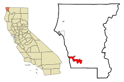
Macdoel is a census-designated place (CDP) in Siskiyou County, California, United States. Macdoel is located on U.S. Route 97 approximately halfway between Klamath Falls, Oregon and Weed. Its population is 86 as of the 2020 census, down from 133 from the 2010 census.

<span class="mw-page-title-main">McCloud, California</span> Census-designated place in California

McCloud is a small town and census-designated place (CDP) in Siskiyou County, California, United States. Its population is 945 as of the 2020 census, down from 1,101 from the 2010 census.

<span class="mw-page-title-main">West Modesto, California</span> Census-designated place in California, United States

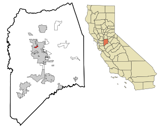
West Modesto is a census-designated place (CDP) in Stanislaus County, California, United States. The population was 5,682 at the 2010 census, down from 6,096 at the 2000 census. It is part of the Modesto Metropolitan Statistical Area.

<span class="mw-page-title-main">Lemon Cove, California</span> Census designated place in California, United States

Lemon Cove is a census-designated place (CDP) in the San Joaquin Valley in Tulare County, California, United States. The population was 308 at the 2010 census, up from 298 at the 2000 census.

<span class="mw-page-title-main">Linda, California</span> Census-designated place in California, United States

Linda is a census-designated place (CDP) in Yuba County, California, United States. The population was 17,773 at the 2010 census, up from 13,474 at the 2000 census. Linda is located 2 miles (3.2 km) north-northwest of Olivehurst.

References

  1. "2010 Census U.S. Gazetteer Files – Places – California". United States Census Bureau.
  2. "Siletz Talking Dictionary" . Retrieved June 4, 2012.
  3. Climate Summary for Klamath, California
  4. "POINT ARENA, CALIFORNIA (044577)". Western Regional Climate Center. Retrieved November 18, 2015.
  5. KHV 10
  6. "2010 Census Interactive Population Search: CA - Klamath CDP". U.S. Census Bureau. Archived from the original on July 15, 2014. Retrieved July 12, 2014.
  7. "U.S. Census website". United States Census Bureau . Retrieved January 31, 2008.
  8. "Babe loses head, Bunyan not a suspect". Newsvine.com. November 24, 2007. Retrieved November 26, 2007.
  9. "Tour-Thru Tree, Klamath, California". RoadsideAmerica.com. Retrieved January 19, 2021.
  10. "Senators". State of California. Retrieved April 5, 2013.
  11. "Members Assembly". State of California. Retrieved March 2, 2013.
  12. "California's 2nd Congressional District - Representatives & District Map". Civic Impulse, LLC. Retrieved March 1, 2013.