
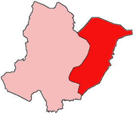
Klay District is one of four administrative districts of Bomi County, Liberia. [1] As of 2008 the population was 22,355. [2]
Klay District is one of four administrative districts of Bomi County, Liberia. [1] As of 2008 the population was 22,355. [2]

Liberia, officially the Republic of Liberia, is a country on the West African coast. It is bordered by Sierra Leone to its northwest, Guinea to its north, Ivory Coast to its east, and the Atlantic Ocean to its south-southwest. It has a population of around 5 million and covers an area of 111,369 square kilometres (43,000 sq mi). English is the official language, but over 20 indigenous languages are spoken, representing the numerous ethnic groups who make up more than 95% of the population. The country's capital and largest city is Monrovia.
The economy of Liberia is extremely underdeveloped, largely due to the First Liberian Civil War from 1989–96. Liberia itself is one of the poorest and least developed countries in the world.

Monrovia is the capital city of the West African country of Liberia. Located on the Atlantic Coast at Cape Mesurado, Monrovia had a population of 1,010,970 as of the 2008 census. With 29% of the total population of Liberia, Monrovia is the country's most populous city.

Montserrado County is a county in the northwestern portion of the West African nation of Liberia. One of 15 counties that comprise the first-level of administrative division in the nation, it is composed of Seventeen districts. As of the 2008 Census, it had a population of 1,118,241, making it the most populous county in Liberia. The area of the county measures 1,912.7 square kilometres (738.5 sq mi), the smallest in the country. Bensonville serves as the capital.
Grand Cape Mount is a county in the northwestern portion of the West African nation of Liberia. One of 15 counties that constitute the first-level of administrative division in the nation, it has five districts. Robertsport serves as the capital with the area of the county measuring 5,162 square kilometres (1,993 sq mi). As of the 2008 Census, it had a population of 129,817, making it the eighth most populous county in Liberia. The county is bordered by Gbarpolu County to the northeast and Bomi County to the southeast. The northern part of Grand Cape Mount borders the nation of Sierra Leone, while to the west lies the Atlantic Ocean.

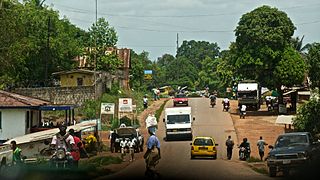
Tubmanburg, also known as Bomi and formerly known as Vaitown, is the capital of Bomi County in Liberia. It lies in the Bomi Hills northwest of Monrovia and was an iron ore and diamond mining centre until it was largely destroyed in the First Liberian Civil War. During the Second Liberian Civil War, it was the headquarters of the Liberians United for Reconciliation and Democracy rebel group. Most residents are members of the Vai tribe.

Gbarnga is the capital city of Bong County, Liberia, lying north east of Monrovia. During the First Liberian Civil War, it was the base for Charles Taylor's National Patriotic Front of Liberia. Cuttington College, a private, Episcopal-affiliated institution, is located near the town. Its campus was once home to the Africana Museum, which was destroyed during the civil war.
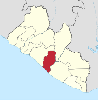
Bomi is a county in the northwestern portion of the West African nation of Liberia. The county was established in 1984. The county's area is 746 square miles (1,900 km2).

Margibi is a county on the north to central coast of Liberia. One of 15 counties that constitute the first-level of administrative division in the nation, it has five districts. Kakata serves as the capital with the area of the county measuring 2,616 square kilometres (1,010 sq mi). As of the 2008 Census, it had a population of 199,689, making it the sixth most populous county in Liberia.
Sinoe is one of Liberia's 15 counties and it has 17 districts. Greenville is the county's capital. As of the 2008 Census, it had a population of 104,932, making it one of the least populous counties in Liberia. Sinoe has the third-largest area of all Liberia's counties; it has the second least-dense population after Gbarpolu County. The County was originally a colony in the name Mississippi-in-Africa, under auspices of a chapter of the American Colonization Society as it was created with slaves from Mississippi to Liberia.

River Gee is a county in the southern portion of Liberia. One of 15 counties that constitute the first-level of administrative division in the nation, it has six districts. Fish Town serves as the capital with the area of the county measuring 5,113 square kilometres (1,974 sq mi). As of the 2008 Census, it had a population of 66,789, making it the third-least populous county in Liberia. It was created in 2000.
Zwedru is the capital of Grand Gedeh County, one of the 15 counties in Liberia. Zwedru is located in Tchien District of Grand Gedeh County, near the Cavalla River in the country's south-eastern region and near the border with Côte d'Ivoire. It is located 350 miles southeast from the capital city of Monrovia. The town is a stronghold of the Krahn tribe.
Kakata, is the capital city of Liberia's Margibi County and is located in Kakata District just over the Du River bridge which is its border with Todee District. It is a transit town at the heart of the historical natural rubber cultivation belt in Liberia. The city is colloquially known as "Kak City". The City host the Office of the National Civil Society Council of Liberia, Margibi Chapter. The Council which is headed by Mr. Friday Edwin Crusor, is known for its diligent role in Advocacy, Dialogue, and Peacebuilding among others.

Bopolu is the capital city of Gbarpolu County, Liberia, and is located 100 kilometers north of Monrovia. As of the 2008 census, Bopolu has a population of 2908. Of this, 1547 were male and 1361 female.
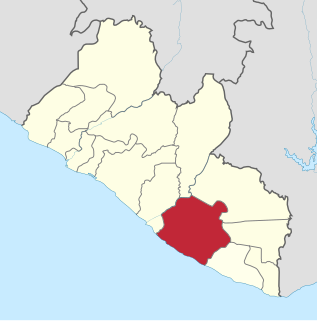
Seuhn Mecca District is one of four administrative districts of Bomi County, Liberia.
Greater Monrovia is one of four districts located in Montserrado County, Liberia. It contains the country's capital Monrovia. It recorded a population of 970,824 in the 2008 census.
Dewoin District is one of four administrative districts of Bomi County, Liberia. As of 2008 the population was 12,782.

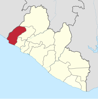
Senjeh District is one of four administrative districts of Bomi County, Liberia. As of 2008 the population was 29,325.
Rivercess County is a county in the south-central portion of the West African nation of Liberia. One of 15 counties that compose the first-level of administrative division in the nation, it has six districts. Cesstos City serves as the capital with the area of the county measuring 5,594 square kilometres (2,160 sq mi). As of the 2008 Census, it had a population of 71,509, making it the second least populous county in Liberia after Grand Kru County.
Karnplay City is one of the five cities in Nimba County, Liberia. It is located about 12 miles (19.3 km) from the Ivorian border. According to the 2008 census, released by the Liberia Institute of Statistics and Geo-Information Services (LISGIS), Karnplay is the 4th largest city in Nimba, with a population of 5,585 inhabitants.
Coordinates: 6°41′39″N10°52′28″W / 6.69417°N 10.87444°W
| This Liberia location article is a stub. You can help Wikipedia by expanding it. |