Kremmling, Colorado

Last updated

Kremmling, Colorado
DSCN1888 danhoarekremmling e 600.jpg
Tourist-oriented wooden structure in Kremmling
Grand County Colorado Incorporated and Unincorporated areas Kremmling Highlighted 0841560.svg
Location of Kremmling in Grand County, Colorado.
Coordinates: 40°03′23″N106°22′41″W / 40.05639°N 106.37806°W / 40.05639; -106.37806
Country Flag of the United States (23px).png  United States
State Flag of Colorado.svg  Colorado
County [1] Grand
Founded1881
Incorporated (town) May 14, 1904 [2]
Government
  Type Statutory Town [1]
Area
[3]
  Total1.31 sq mi (3.39 km2)
  Land1.31 sq mi (3.39 km2)
  Water0.00 sq mi (0.00 km2)
Elevation
[4]
7,399 ft (2,255 m)
Population
 (2020) [5]
  Total1,509
  Density1,200/sq mi (450/km2)
Time zone UTC-7 (Mountain (MST))
  Summer (DST) UTC-6 (MDT)
ZIP code [6]
80459
Area code 970
FIPS code 08-41560
GNIS feature ID2412848 [4]
Website Town of Kremmling

The Town of Kremmling is a Statutory Town in Grand County, Colorado, United States. The town population was 1,509 at the 2020 United States Census. [5] The town sits along the upper Colorado River in the lower arid section of Middle Park between Byers Canyon and Gore Canyon. The town was founded in 1881 during the Colorado Silver Boom days, but the lack of mineral resources in the nearby mountains made the town grow very slowly in the early days.

Contents

History

The settlement started with only a general store, run by a man named Rudolph "Kare" Kremmling, built on the north side of Muddy Creek. In 1881, two brothers, Aaron and John Kinsey, made part of their ranch into a town and called it Kinsey City. Kare moved his store across the river to the new site and soon people were calling this place Kremmling. The original post office was called Kinsey City and ran from 1881 to 1885, with Kare Kremmling the first postmaster. The name Kremmling was not officially recognized until 1895. After the Moffat railroad—the Denver, Northwestern & Pacific Railway—arrived in July 1906, Kremmling became the county's central shipping point. It was incorporated May 14, 1904. In the 20th century, ranching became the main industry in the valley in the vicinity of the town. In 1906, Kasper Schuler built the first brick building in town. The Schuler bottling works occupied the first floor, while the Schuler House, a boarding house run by Miss Kienholz, occupied the second. In 1933, the building became the Hotel Eastin.

Kremmling was featured in W. Eugene Smith's photographic essay "Country Doctor" in the September 20, 1948, issue of LIFE . [7]

Geography

According to the United States Census Bureau, the town has a total area of 1.3 square miles (3.4 km2), all of it land.

The town is located approximately at the mouth of both the Blue River, which descends from the south, and Muddy Creek, which descends from the north. This location provides valley access to Dillon, Colorado, and the ski resorts of Summit County, and Rabbit Ears Pass (renowned for world-class snowmobiling) at the Continental Divide, which then descends into Steamboat Springs.

Demographics

Historical population
CensusPop.Note
1910 141
1920 25480.1%
1930 2612.8%
1940 567117.2%
1950 6239.9%
1960 576−7.5%
1970 76432.6%
1980 1,29669.6%
1990 1,166−10.0%
2000 1,57835.3%
2010 1,444−8.5%
2020 1,5094.5%
U.S. Decennial Census

Climate

This climate type is dominated by the winter season, a long, bitterly cold period with short, clear days, relatively little precipitation mostly in the form of snow, and low humidity. According to the Köppen Climate Classification system, Kremmling has a continental climate, abbreviated "Dfb" on climate maps. [8]

Climate data for Kremmling, Colorado, 19912020 normals, extremes 1908present
MonthJanFebMarAprMayJunJulAugSepOctNovDecYear
Record high °F (°C)55
(13)
61
(16)
69
(21)
77
(25)
85
(29)
92
(33)
94
(34)
93
(34)
89
(32)
81
(27)
69
(21)
60
(16)
94
(34)
Mean maximum °F (°C)44.3
(6.8)
47.2
(8.4)
59.3
(15.2)
69.7
(20.9)
78.1
(25.6)
86.0
(30.0)
89.3
(31.8)
86.7
(30.4)
82.7
(28.2)
73.4
(23.0)
58.3
(14.6)
47.3
(8.5)
89.7
(32.1)
Mean daily maximum °F (°C)26.4
(−3.1)
31.3
(−0.4)
43.3
(6.3)
53.3
(11.8)
63.7
(17.6)
75.5
(24.2)
81.3
(27.4)
79.0
(26.1)
71.7
(22.1)
58.1
(14.5)
42.4
(5.8)
28.7
(−1.8)
54.6
(12.5)
Daily mean °F (°C)12.4
(−10.9)
17.2
(−8.2)
29.7
(−1.3)
38.7
(3.7)
47.6
(8.7)
56.9
(13.8)
62.8
(17.1)
60.7
(15.9)
52.8
(11.6)
40.7
(4.8)
27.9
(−2.3)
14.8
(−9.6)
38.5
(3.6)
Mean daily minimum °F (°C)−1.5
(−18.6)
3.1
(−16.1)
16.0
(−8.9)
24.0
(−4.4)
31.4
(−0.3)
38.3
(3.5)
44.2
(6.8)
42.4
(5.8)
33.8
(1.0)
23.4
(−4.8)
13.4
(−10.3)
0.9
(−17.3)
22.5
(−5.3)
Mean minimum °F (°C)−22.9
(−30.5)
−17.9
(−27.7)
−3.9
(−19.9)
11.6
(−11.3)
20.8
(−6.2)
29.9
(−1.2)
36.5
(2.5)
34.7
(1.5)
22.6
(−5.2)
9.2
(−12.7)
−6.0
(−21.1)
−19.4
(−28.6)
−26.7
(−32.6)
Record low °F (°C)−46
(−43)
−49
(−45)
−36
(−38)
−13
(−25)
9
(−13)
20
(−7)
26
(−3)
22
(−6)
11
(−12)
−13
(−25)
−31
(−35)
−42
(−41)
−49
(−45)
Average precipitation inches (mm)0.73
(19)
0.72
(18)
0.72
(18)
1.15
(29)
1.42
(36)
0.88
(22)
1.40
(36)
1.31
(33)
1.28
(33)
0.91
(23)
0.74
(19)
0.74
(19)
12.00
(305)
Average snowfall inches (cm)10.7
(27)
9.1
(23)
6.0
(15)
5.8
(15)
1.9
(4.8)
0.0
(0.0)
0.0
(0.0)
0.0
(0.0)
0.1
(0.25)
3.1
(7.9)
6.5
(17)
9.2
(23)
52.4
(132.95)
Average precipitation days (≥ 0.01 in)7.97.36.47.68.46.610.011.28.86.06.67.093.8
Average snowy days (≥ 0.1 in)8.97.65.64.01.00.10.00.00.21.76.08.143.2
Source 1: NOAA [9]
Source 2: National Weather Service [10]

See also

Related Research Articles

<span class="mw-page-title-main">Pagosa Springs, Colorado</span> Town in Colorado, United States

Pagosa Springs is a home rule municipality that is the county seat, the most populous community, and the only incorporated municipality in Archuleta County, Colorado, United States. The population was 1,571 at the 2020 census. Approximately 65 percent of the land in Archuleta County is either San Juan National Forest, Weminuche and South San Juan wilderness areas, or Southern Ute Indian reservation land.

<span class="mw-page-title-main">Coal Creek, Jefferson County, Colorado</span> Census-designated place in Boulder, Gilpin, and Jefferson counties in Colorado, United States

Coal Creek, commonly known as Coal Creek Canyon, is a census-designated place (CDP) located in and governed by Jefferson, Boulder, and Gilpin counties in Colorado, United States, but primarily Jefferson County. The population of the Coal Creek CDP was 2,494 at the United States Census 2020. The Golden post office serves the area.

<span class="mw-page-title-main">Salida, Colorado</span> City in Colorado, United States

Salida is the statutory city that is the county seat and the most populous municipality of Chaffee County, Colorado, United States. The population was 5,666 at the 2020 census.

<span class="mw-page-title-main">Paonia, Colorado</span> Town in Colorado, United States

Paonia is a statutory town in Delta County, Colorado, United States. The population was 1,447 at the 2020 census.

<span class="mw-page-title-main">Hot Sulphur Springs, Colorado</span> Town in Colorado, United States

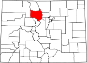
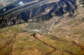
Hot Sulphur Springs is a statutory town and the county seat of Grand County, Colorado, United States. The town is located near Byers Canyon between Granby and Kremmling, 95 miles (153 km) northwest of Denver and 30 miles (48 km) northwest of Winter Park. The town population was 687 at the 2020 census. Its elevation is 7,680 feet (2,340 m).

<span class="mw-page-title-main">Evergreen, Colorado</span> Census Designated Place in Colorado, United States

Evergreen is an unincorporated town, a post office, and a census-designated place (CDP) located in and governed by Jefferson County, Colorado, U.S. The CDP is a part of the Denver–Aurora–Lakewood, CO Metropolitan Statistical Area. The Evergreen post office has the ZIP Codes 80439 and 80437. At the 2020 census, the population of the Evergreen CDP was 9,307. The Evergreen Metropolitan District provides services.

<span class="mw-page-title-main">Meeker, Colorado</span> Town in and county seat of Rio Blanco County, Colorado, United States

Meeker is the Statutory Town in and the county seat of Rio Blanco County, Colorado, United States, that is the most populous municipality in the county. The town population was 2,374 at the 2020 United States Census.

<span class="mw-page-title-main">Hayden, Colorado</span> Town in Colorado, United States

The Town of Hayden is a home rule municipality located in Routt County, Colorado, United States. The town population was 1,941 at the 2020 United States Census. Hayden is a part of the Steamboat Springs, CO Micropolitan Statistical Area. The town sits along U.S. Highway 40 in the Yampa River Valley between Craig and Steamboat Springs. Hayden is located near the Yampa Valley Regional Airport, by which Hayden is one of the smallest communities in the U.S. to have mainline passenger jet service provided by American Airlines, Delta Air Lines, Southwest Airlines and United Airlines on a scheduled basis.

<span class="mw-page-title-main">Cimarron, New Mexico</span> Village in New Mexico, United States

Cimarron is a village in Colfax County, New Mexico, United States, which sits on the eastern slopes of the Sangre de Cristo Mountains. The population was 792 at the 2020 census, making it the fourth most populous municipality in Colfax County.

<span class="mw-page-title-main">Emery, Utah</span> Town in Utah, United States

Emery is a town in Emery County, Utah, United States. The population was 288 at the 2010 census.

<span class="mw-page-title-main">Big Sky, Montana</span> Census-designated place in Montana, United States

Big Sky is an unincorporated community and census-designated place (CDP) in Gallatin and Madison counties in southwestern Montana, United States. As of the 2020 census, it had a population of 3,591, up from 2,308 in 2010. It is 44 miles (71 km) by road southwest of Bozeman. The primary industry of the area is tourism.

<span class="mw-page-title-main">Muddy Creek (Colorado)</span> River

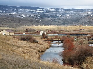
Muddy Creek is a tributary of the Colorado River, approximately 60.5 miles (97.4 km) long, in north central Colorado in the United States.

<span class="mw-page-title-main">Middle Park (Colorado basin)</span> High basin in the state of Colorado

Middle Park is a high basin in the Rocky Mountains of north-central Colorado in the United States. It is located in Grand County, on the southwest slope of Rocky Mountain National Park, approximately 50 miles (80 km) west of Boulder.

<span class="mw-page-title-main">Colorado State Highway 14</span> State highway in Colorado, United States

State Highway 14 in the U.S. state of Colorado is an east–west state highway approximately 237 miles (381 km) long, making it the longest state highway in Colorado. It traverses four counties along the northern edge of the state, spanning a geography from the continental divide in the Rocky Mountains to the Great Plains, and including North Park, the Poudre Canyon, and the Pawnee National Grassland. It provides the most direct route from Fort Collins westward via Cameron Pass to Walden and Steamboat Springs, and eastward across the plains to Sterling.

<span class="mw-page-title-main">Muddy Pass (Continental Divide)</span> Mountain pass in the state of Colorado

Muddy Pass is a high mountain pass in the Rocky Mountains of northern Colorado in the United States.

<span class="mw-page-title-main">Hanksville, Utah</span> Town in the state of Utah, United States

Hanksville is a small town in Wayne County, Utah, United States, at the junction of State Routes 24 and 95. The population was 219 at the 2010 census.

<span class="mw-page-title-main">Bailey, Colorado</span> Unincorporated community in Colorado, United States

Bailey is an unincorporated community and U.S. Post Office in northeastern Park County, Colorado, United States. Bailey's Post Office ZIP Code is 80421.

<span class="mw-page-title-main">Grant, Colorado</span> Unincorporated community in Park County, Colorado, United States

Grant is an unincorporated community and a U.S. Post Office in Park County, Colorado, United States.

<span class="mw-page-title-main">Parshall, Colorado</span> Census Designated Place in Colorado, United States

Parshall is an unincorporated town, a post office, and a census-designated place (CDP) located in and governed by Grand County, Colorado, United States. The Parshall post office has the ZIP Code 80468. At the United States Census 2020, the population of the Parshall CDP was 42.

References

  1. 1 2 "Active Colorado Municipalities". State of Colorado, Department of Local Affairs. Archived from the original on December 12, 2009. Retrieved September 1, 2007.
  2. "Colorado Municipal Incorporations". State of Colorado, Department of Personnel & Administration, Colorado State Archives. December 1, 2004. Retrieved September 2, 2007.
  3. "2019 U.S. Gazetteer Files". United States Census Bureau. Retrieved July 1, 2020.
  4. 1 2 U.S. Geological Survey Geographic Names Information System: Kremmling, Colorado
  5. 1 2 United States Census Bureau. "Kremmling town; Colorado" . Retrieved April 23, 2023.
  6. "ZIP Code Lookup". United States Postal Service. Archived from the original (JavaScript/HTML) on November 4, 2010. Retrieved October 21, 2007.
  7. Smith, W. Eugene. "Country Doctor," LIFE (magazine), September 20, 1948. Retrieved April 17, 2018
  8. Climate Summary for Kremmling, Colorado
  9. "U.S. Climate Normals Quick Access". National Oceanic and Atmospheric Administration. Retrieved August 8, 2022.
  10. "NOAA Online Weather Data". National Weather Service. Retrieved August 8, 2022.