
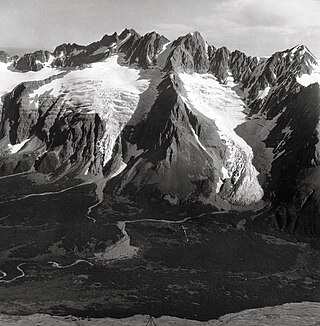
Mount Bertha is a 10,204-foot glaciated mountain summit located in the Fairweather Range of the Saint Elias Mountains, in southeast Alaska, United States.

Black Peak is a prominent 6,385-foot (1,946-meter) glaciated mountain summit located in Lake Clark National Park and Preserve, in the Chigmit Mountains of the Aleutian Range, in the US state of Alaska. It is the second-highest non-volcanic peak in the Chigmit Mountains, and fourth-highest overall. The mountain is situated 22 mi (35 km) west of Cook Inlet, 90 mi (145 km) west-southwest of Anchorage, and 10.2 mi (16 km) northeast of Double Peak, which is the nearest higher peak. Although modest in elevation, relief is significant since the mountain rises up 6,200 feet from North Fork Big River in about two miles. The mountain's descriptive name was published in 1912 by the United States Coast and Geodetic Survey. The months May through June offer the most favorable weather for viewing or climbing the peak.
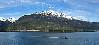
Face Mountain is a 5,052 ft (1,540 m) mountain summit located in the Boundary Ranges of the Coast Mountains, in the U.S. state of Alaska. The peak is situated 4.2 mi (7 km) west-northwest of Skagway, and 4.3 mi (7 km) north of Mount Harding, on land managed by Tongass National Forest. Although modest in elevation, relief is significant since Face Mountain rises above tidewater of Taiya Inlet in less than 2.5 miles. This geographic feature was named "Parsons Peak" in 1897 by the United States Coast and Geodetic Survey, and has had variant names "Gnome Mountain", and "The Sphinx" used locally to describe a face in the rock. The mountain's present name and summit location was officially adopted in 1985 by the U.S. Board on Geographic Names, however USGS maps still show the old name, Parsons Peak, as the summit. Precipitation runoff from the mountain drains into tributaries of Taiya Inlet.
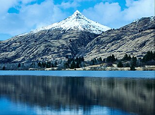
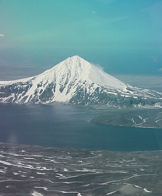
Pyramid Mountain is a 2,395-foot (730-meter) elevation mountain summit located on Kodiak Island in the US state of Alaska. The mountain is situated 7.5 mi (12 km) west of Kodiak. Although modest in elevation, relief is significant since the peak rises over 2,300 feet above Buskin Lake in only 1.5 mi (2 km). This peak's descriptive name was first published in 1943 by the United States Coast and Geodetic Survey.

Mount Carmack is a prominent 6,808-foot-elevation (2,075-meter) mountain summit located in the Boundary Ranges of the Coast Mountains, in the U.S. state of Alaska. The peak is situated 7 mi (11 km) north-northeast of Skagway, and 3.5 mi (6 km) south of Mount Cleveland, on land managed by Tongass National Forest. As the highpoint on the divide between the Taiya River and the Skagway River, precipitation runoff from the mountain drains east into the Skagway River and west into Taiya River, both of which empty into Taiya Inlet. Although modest in elevation, relief is significant since Mount Carmack rises 6,800 feet above the Taiya valley in less than 2 mi (3 km), and 5,800 feet above Skagway valley in about 2 miles. Mount Carmack has a lower subsidiary summit, elevation 6,621 ft (2,020 m), about 0.5 mi (1 km) to the northeast of the true summit. The USGS topographic map has this lower northeast peak labelled as Mount Carmack.

Grayrock Peak is a 12,504-foot-elevation (3,811-meter) mountain summit located in San Juan County, Colorado, United States.
Icy Peak is a 4,550-foot-elevation (1,390-meter) mountain summit in Alaska, United States.

Porter Peak is a 4,839-foot (1,475 m) mountain summit in Alaska.

Mount Stepo is a 3,828-foot-elevation (1,167-meter) mountain summit in Alaska.

Mount Becharof is a 3,146-foot-elevation (959-meter) mountain summit in Alaska.

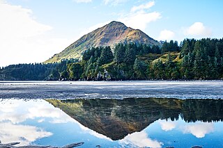
Barometer Mountain is a 2,506-foot-elevation (764-meter) summit in Alaska.

Cope Mountain is a 2,496-foot-elevation (761-meter) summit in Alaska.
Devils Prongs is a 2,175-foot-elevation (663-meter) mountain in Alaska.
Eickelberg Peak is a 3,648-foot-elevation (1,112-meter) summit in Alaska, United States.

West Saint Peak is a 3,337-foot-elevation (1,017-meter) summit in Alaska.

Mount Emmerich is a 6,877-foot-elevation (2,096-meter) mountain summit in Alaska.
Mount Sumdum is a 6,666-foot-elevation (2,032-meter) mountain summit in Alaska, United States.
Nun Mountain is a 4,329-foot-elevation (1,319-meter) mountain summit in Alaska.

Mount Ada is a 4,528-foot-elevation (1,380-meter) mountain summit in Alaska, United States.

Ptarmigan Peak is a 2,972-foot-elevation (906-meter) mountain summit in Alaska, United States.

