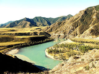
The Altai Mountains, also spelled Altay Mountains, are a mountain range in Central and East Asia, where Russia, China, Mongolia and Kazakhstan converge, and where the rivers Irtysh and Ob have their headwaters. The massif merges with the Sayan Mountains in the northeast, and gradually becomes lower in the southeast, where it merges into the high plateau of the Gobi Desert. It spans from about 45° to 52° N and from about 84° to 99° E.

Belukha Mountain, located in the Katun Mountains, is the highest peak of the Altai Mountains in Russia and the highest of the system of the South Siberian Mountains. It is part of the Golden Mountains of Altai World Heritage Site.

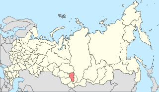
The Altai Republic, also known as Gorno-Altai Republic, and colloquially, and primarily referred to in Russian to distinguish from the neighbouring Altai Krai as the Gornyi Altai, is a republic of Russia located in southern Siberia. It is a part of the Siberian Federal District, and covers an area of 92,903 square kilometers (35,870 sq mi); with a population of 210,924 residents. It is the least-populous republic of Russia and least-populous federal subject in the Siberian Federal District. Gorno-Altaysk is the capital and the largest town of the republic.

The Tawan Bogd is a mountain massif in Mongolia, near the triple border with China and Russia. Its highest peak, the Khüiten Peak, is the highest point of Mongolia at 4374 meters above sea level.

Diluvium is an archaic term applied during the 1800s to widespread surficial deposits of sediments that could not be explained by the historic action of rivers and seas. Diluvium was initially argued to have been deposited by the action of extraordinary floods of vast extent, specifically the Noachian Flood.

Chuya Belki is a mountainous region in the Altai, Altai Republic, Russia. There are a number of glaciers on the northern part of the slopes of the main ridges. The Chuya Belki are named after the Chuya River and after their "Belki" type of ridges.

Ukok Plateau is a plateau covered by grasslands located in southwestern Siberia, in the Altai Mountains region of Russia near the borders with China, Kazakhstan and Mongolia. The plateau is recognized as part of the UNESCO World Heritage Site entitled Golden Mountains of Altai as an important environmental treasure. It provides a habitat for many of the world's endangered species including one of its least studied predatory animals: the snow leopard. Other endangered species protected there include the argali mountain sheep, the steppe eagle, and the black stork. It is also one of the last remaining remnants of the mammoth steppe. There are several threats to the preservation of the Ukok Plateau, including overuse of the steppe by ranchers, a proposed road, and plans for a gas pipeline between China and Russia.

South Central Siberia is a geographical region north of the point where Russia, China, Kazakhstan and Mongolia come together.
Ledoyom is a term proposed by the Russian geologist V.P. Nekhoroshev for intermontane depressions which might get completely filled by glaciers from the surrounding mountains at the maxima of glaciation.

Giant current ripples are active channel topographic forms up to 20 m high, which develop within near-thalweg areas of the main outflow valleys created by glacial lake outburst floods. Giant current ripple marks are large scale analogues of small current ripples formed in sandy stream sediments.

The Altai flood refers to the cataclysmic flood(s) that, according to some geomorphologists, swept along the Katun River in the Altai Republic at the end of the last ice age. These glacial lake outburst floods were the result of periodic sudden ruptures of ice dams like those triggering the Missoula floods.

Turkvision Song Contest 2013 was the inaugural edition of the Turkvision Song Contest, held in Eskişehir, Turkey. Twenty-four Turkic regions, which have either a large Turkic population or a widely spoken Turkic language, participated in the contest. The semi-final took place on 19 December 2013, while the final took place on 21 December 2013.

Saylyugemsky National Park sits at the mountainous "X" where the borders of Russia, Kazakhstan, Mongolia and China meet in the Altai Mountains of central Asia. Because of its remoteness and position at the meeting points of mountains, steppes, desert and forest, it is a globally important natural reserve for biodiversity. The park was formally established in 2010–2012, with a particular purpose of protecting the vulnerable Altai argali mountain sheep and the endangered Snow leopard. The component Saylyugem Mountains are a ridge of the Altai, and stretch to the northeast to the Sayan Mountains. The climate is cold and semi-arid. Administratively, the park is located in the Kosh-Agachsky District of the Altai Republic. While ecotourism has a stated role, visits to the territory currently require special passes from park administration, and activities are limited to roads and trails.

The Altai montane forest and forest steppe ecoregion covers patches of the subalpine forest belt on the Altai Mountains, crossing the border region where Russia, Kazakhstan, Mongolia and China meet. The region has high biodiversity, as it is located in transition zones between different ecoregions, altitudes, and climate zones. It is in the Palearctic realm, with a Cold semi-arid climate. It covers 35,199,998 km2 (13,590,795 sq mi).
Kuray is a rural locality and the administrative centre of Kurayskoye Rural Settlement of Kosh-Agachsky District, the Altai Republic, Russia. The population was 427 as of 2016. There are 6 streets.

Aktash is a rural locality in Ulagansky District, the Altai Republic, Russia. The population was 2418 as of 2016. There are 24 streets.

The Altai alpine meadow and tundra ecoregion is a terrestrial ecoregion covering the higher elevation of the Altai Mountains at the center of the "X" formed by the borders separating Russia, Kazakhstan, China, and Mongolia. The mountain peaks are the farthest north in Central Asia, separating the plains of Siberia to the north from the hot, dry deserts to the south. Altitudes above 2,400 meters display characteristics of tundra, with patches of alpine meadows and some trees immediately below the treeline. The ecoregion is in the montane grasslands and shrublands biome, and the Palearctic realm, with a humid continental climate. It covers an area of 90,132 square kilometres (34,800 sq mi).

The South Siberian Mountains are one of the largest mountain systems of the Russian Federation. The total area of the system of mountain ranges is more than 1.5 million km². The South Siberian Mountains are located in the Siberian and Far Eastern Federal Districts of Russia, as well as partly in Mongolia. The territory of the mountain system is one of the Great Russian Regions.

Maasheybash is a mountain in the Altai Republic, Russia. At 4,177 m (13,704 ft) it is the highest summit in the Northern Chuya Range, part of the Chuya Belki, Altai Mountains, South Siberian System.


