
Bethel is a city in the U.S. state of Alaska, located on the Kuskokwim River approximately 50 miles (80 km) from where the river discharges into Kuskokwim Bay. It is the largest community in western Alaska and in the Unorganized Borough and the eighth-largest in the state. Bethel has a population of 6,325 as of the 2020 census, up from 6,080 in 2010.

The Alaska Range is a relatively narrow, 600-mile-long (950 km) mountain range in the southcentral region of the U.S. state of Alaska, from Lake Clark at its southwest end to the White River in Canada's Yukon Territory in the southeast. Denali, the highest mountain in North America, is in the Alaska Range. The range is part of the American Cordillera.
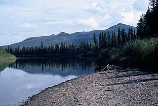
The Nowitna River is a 250-mile (400 km) tributary of the Yukon River in the U.S. state of Alaska. The river flows northeast from the Kuskokwim Mountains through Nowitna National Wildlife Refuge and enters the larger river 38 miles (61 km) northeast of Ruby and southwest of Tanana. Major tributaries include the Titna, Big Mud, Little Mud, Lost, and Sulatna rivers.
The Tanana River is a 584-mile (940 km) tributary of the Yukon River in the U.S. state of Alaska. According to linguist and anthropologist William Bright, the name is from the Koyukon (Athabaskan) tene no, tenene, literally "trail river".

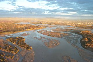
The Kuskokwim River or Kusko River is a river, 702 miles (1,130 km) long, in Southwest Alaska in the United States. It is the ninth largest river in the United States by average discharge volume at its mouth and seventeenth largest by basin drainage area. The Kuskokwim River is the longest river system contained entirely within a single U.S. state.

The Koyukuk River is a 425-mile (684 km) tributary of the Yukon River, in the U.S. state of Alaska. It is the last major tributary entering the Yukon before the larger river empties into the Bering Sea.

Beaver Creek is a 180-mile (290 km) tributary of the Yukon River in the U.S. state of Alaska. The creek begins at the confluence of Champion and Bear creeks in the White Mountains National Recreation Area, about 50 miles (80 km) north of Fairbanks. From there it flows west around the southern end of the White Mountains, then northeast into the Yukon Flats National Wildlife Refuge, then west into the Yukon River downstream of Beaver.
The Chandalar River is a 100-mile (160 km) tributary of the Yukon River in the U.S. state of Alaska. Its peak flow, recorded by the United States Geological Survey (USGS) between 1964 and 1974 at a stream gauge at Venetie, was 62,800 cubic feet per second (1,780 m3/s) on June 9, 1968.
Togiak Lake is a 13 mi (21 km) lake in the U.S. state of Alaska, which extends South-West from mouth of Izavieknik River, 75 miles (121 km) northeast of Goodnews Bay, Kilbuck-Kuskokwim Mountains.

Southwest Alaska is a region of the U.S. state of Alaska. The area is not exactly defined by any governmental administrative region(s); nor does it always have a clear geographic boundary.
Napaimute is an unincorporated Alaska Native village located in the Bethel Census Area of the U.S. state of Alaska. It is classified as an Alaskan Native Village Statistical Area. As of the 2010 U.S. Census, it has a population of 2. This is up from a population of zero in 2000.
Prindle Volcano is an isolated basaltic cinder cone located in eastern Alaska, United States, in the headwaters of the East Fork of the Fortymile River, approximately 80 kilometers northeast of Tok, Alaska. The cone is fresh-looking and has a base approximately 900 metres wide. It is the northwesternmost expression of the Northern Cordilleran Volcanic Province. The cinder cone, and an approximately 11-kilometre (6.8-mile) long lava flow which breached the margin of the cone, erupted in the Pleistocene approximately 176,000 years ago. The lava flow extends to the southeast, then turns southwest and continues in a river valley.
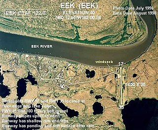
The Eek River is a 108-mile (174 km) tributary of the Kuskokwim River in the U.S. state of Alaska. It is south of the Kwethluk River and north of the Kanektok River, which also drain into the Kuskokwim or Kuskokwim Bay on the Bering Sea.
Poorman is an unincorporated community in the Yukon-Koyukuk Census Area of the Unorganized Borough of the U.S. state of Alaska, in the Kilbuck-Kuskokwin Mountains. It lies along the left bank of Poorman Creek on an unpaved road 44 miles (71 km) south of the city of Ruby on the Yukon River. Its elevation is 502 feet (153 m). Founded as a gold mining camp in 1913, Poorman possessed a post office from 1915 to 1932. The community's name was officially decided by the Board on Geographic Names in 1944.
The Ray Mountains is a mountain range in central Alaska named for the Ray River, itself named for United States Army Captain Patrick Henry Ray, who established a meteorological station in Barrow, Alaska, in 1881. The mountains are within the Yukon-Tanana Uplands, an area of low mountain ranges that also includes the White Mountains. The Ray Mountains cover an area of 10,600 square miles (27,454 km2) and are bordered on the east by the Yukon River, on the south by the Tozitna River, and on the north by Kanuti National Wildlife Refuge. The highest point in the Ray Mountains is Mount Tozi, which has a summit elevation of 5,519 feet (1,682 m). Other notable peaks include Wolf Mountain, Mount Henry Eakin, the Kokrines Hills, and Moran Dome.

Mount Prindle is a granitic mountain in the Yukon–Tanana Uplands, and is located approximately 45 miles (72 km) north-northeast of Fairbanks, Alaska. The plutons that form the core of the Mount Prindle massif are Late Cretaceous or early Tertiary age. These plutons intruded older metamorphic rocks. Mount Prindle exhibits classic glacial landforms, unlike most of the surrounding Yukon–Tanana Uplands. It is in the Circle Mining District and many of the surrounding creeks have been or are being mined for placer gold. The area has also been prospected for tin and rare earth minerals. Mine roads and hiking trails provide access to the mountain. A 900 feet (270 m) granite wall on an eastern spur of the massif is an attraction for rock climbers.
The Russian Mountains are a mountain range in Bethel Census Area, Alaska, USA.

The Upper Kuskokwim people or Upper Kuskokwim Athabaskans, Upper Kuskokwim Athabascans, and historically Kolchan, Goltsan, Tundra Kolosh, and McGrath Ingalik are an Alaskan Athabaskan people of the Athabaskan-speaking ethnolinguistic group. First delineation of this ethnolinguistic group was described by anthropologist Edward Howard Hosley in 1968, as Kolchan. According to Hosley, "Nevertheless, as a group possessing a history and a culture differing from those of its neighbours, the Kolchan deserve to be recognized as an independent group of Alaskan Athapaskans." They are the original inhabitants of the Upper Kuskokwim River villages of Nikolai, Telida, and McGrath, Alaska. About 25 of a total of 100 Upper Kuskokwim people still speak the language. They speak a distinct Athabaskan language more closely related to Lower Tanana language than to Deg Xinag language, spoken on the middle Kuskokwim. The term used by the Kolchan themselves is Dina'ena, but this is too similar to the adjacent Tanana and Tanaina for introduction into the literature. Nowadays, the term used by the Kolchan themselves is Dichinanek' Hwt'ana. Their neighbors also knew them by this name. In Tanaina they were Kenaniq' ht'an while the Koyukon people to the north referred to them as Dikinanek Hut'ana. The Upper Kuskokwim Athabaskan culture is a hunter-gatherer culture and have a matrilineal system. They were semi-nomadic and lived in semi-permanent settlements.

Sugar Loaf Mountain, also known as Sugar Mountain, is a 4,784 ft (1,460 m) summit located in the Alaska Range, near Denali National Park and Preserve, in Alaska, United States. It is situated 6 mi (10 km) northeast of park headquarters and 6 mi (10 km) southeast of Healy. The George Parks Highway and Alaska Railroad traverse the western base of this mountain as each passes through the Nenana River Gorge. Mount Healy, Sugar's nearest higher neighbor, is set 5.2 mi (8 km) to the west across the gorge. This peak's local descriptive name was published in 1950 by the United States Geological Survey.
The Nulato Hills are a mountain range in western Alaska between the Yukon River and Norton Sound. In the north, they merge into the lowlands of the Selawik River, in the south they extend into the Yukon-Kuskokwim Delta. At the Seward Peninsula level, the continental divide runs through the Nulato Hills. The Anvik River and the Bonasila River have their source in the Nulato Hills.


