
Santa Barbara County, California, officially the County of Santa Barbara, is a county located in the southern region of the U.S. state of California. As of the 2010 census, the population was 423,895. The county seat is Santa Barbara, and the largest city is Santa Maria.

Mission Canyon is a census-designated place and an unincorporated suburb of Santa Barbara, California, in Santa Barbara County, United States. The population was 2,381 at the 2010 census, down from 2,610 at the 2000 census.

Santa Ynez is a census-designated place (CDP) in the Santa Ynez Valley of Santa Barbara County, California.
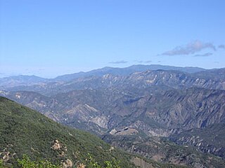
The San Rafael Mountains are a mountain range in central Santa Barbara County, California, U.S., separating the drainages of the Santa Ynez River and the Santa Maria River. They are part of the Transverse Ranges system of Southern California which in turn are part of the Pacific Coast Ranges system of western North America.

The Santa Lucia Mountains or Santa Lucia Range is a rugged mountain range in coastal central California, running from Monterey County southeast for 105 miles (169 km) into central San Luis Obispo County. It includes Cone Peak, which at 5,158 feet (1,572 m) tall and three miles (5 km) from the coast, is the highest peak in proximity to the ocean in the lower 48 United States. The range forms the eastern boundary of the Big Sur region, and was a barrier to exploring the coast of California for early Spanish explorers.
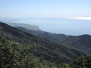
Los Padres National Forest is a United States national forest in southern and central California. Administered by the United States Forest Service, Los Padres includes most of the mountainous land along the California coast from Ventura to Monterey, extending inland. Elevations range from sea level to 8,847 feet (2,697 m).

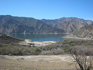
The Santa Ynez River is one of the largest rivers on the Central Coast of California. It is 92 miles (148 km) long, flowing from east to west through the Santa Ynez Valley, reaching the Pacific Ocean at Surf, near Vandenberg Air Force Base and the city of Lompoc.

The Santa Ynez Valley is located in Santa Barbara County, California, between the Santa Ynez Mountains to the south and the San Rafael Mountains to the north. The Santa Ynez River flows through the valley from east to west. The Santa Ynez Valley is separated from the Los Alamos Valley, to the northwest, by the Purisima Hills, and from the Santa Maria Valley by the Solomon Hills. The Santa Rita Hills separate the Santa Ynez Valley from the Santa Rita and Lompoc Valleys to the west.

San Marcos Pass is a mountain pass in the Santa Ynez Mountains in southern California.
Piru Creek is a major stream, about 71 miles (114 km) long, in northern Los Angeles County and eastern Ventura County, California. It is a tributary of the Santa Clara River, the largest stream system in Southern California that is still relatively natural.
Gaviota Peak is a summit in the Santa Ynez Mountains in Santa Barbara County, California. It is located 10 miles (16 km) west of Santa Barbara, 16 miles (26 km) east of Point Conception and 2 miles (3.2 km) from the Pacific Ocean.
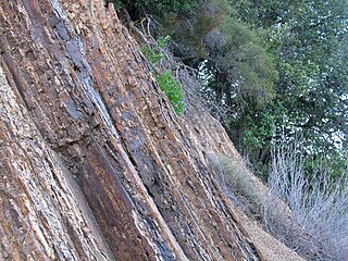
The Vaqueros Formation is a sedimentary geologic unit primarily of Upper Oligocene and Lower Miocene age, which is widespread on the California coast and coastal ranges in approximately the southern half of the state. It is predominantly a medium-grained sandstone unit, deposited in a shallow marine environment. Because of its high porosity and nearness to petroleum source rocks, in many places it is an oil-bearing unit, wherever it has been configured into structural or stratigraphic traps by folding and faulting. Being resistant to erosion, it forms dramatic outcrops in the coastal mountains. Its color ranges from grayish-green to light gray when freshly broken, and it weathers to a light brown or buff color.

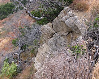
The Coldwater Sandstone is a sedimentary geologic unit of Eocene age found in Southern California, primarily in and south of the Santa Ynez Mountains of Santa Barbara County, and east into Ventura County. It consists primarily of massive arkosic sandstone with some siltstone and shale. Being exceptionally resistant to erosion, outcrops of the Coldwater form some of the most dramatic terrain on the south slope of the Santa Ynez Mountains, with immense white sculpted slabs forming peaks, hogback ridges, and sheer cliff faces.

The Matilija Sandstone is a sedimentary geologic unit of Eocene epoch in the Paleogene Period, found in Santa Barbara and Ventura Counties in Southern California.

The Juncal Formation is a prominent sedimentary geologic unit of Eocene age found in and north of the Santa Ynez Mountain range in southern and central Santa Barbara County and central Ventura County, California. An enormously thick series of sediments deposited over millions of years in environments ranging from nearshore to deep water, it makes up much of the crest of the Santa Ynez range north of Montecito, as well as portions of the San Rafael Mountains in the interior of the county. Its softer shales weather to saddles and swales, supporting a dense growth of brush, and its sandstones form prominent outcrops.
The Jalama Formation is a sedimentary rock formation widespread in southern Santa Barbara County and northern Ventura County, southern California. Of the Late Cretaceous epoch, the unit consists predominantly of clay shale with some beds of sandstone.

Carneros Creek is a southward flowing stream originating in the Santa Ynez Mountains, in Santa Barbara County, California. It flows to Lake Los Carneros Park, under U. S. Highway 101 where it runs in a man-made channel diverted to the west of Santa Barbara Municipal Airport, until it meets Goleta Slough, from whence its waters flow to the Santa Barbara Channel of the Pacific Ocean.

Salsipuedes Creek is a 9.9 miles (15.9 km) long stream, flowing north to join the Santa Ynez River just southeast of Lompoc in Santa Barbara County, California. Salsipuedes Creek, along with its major tributary, El Jaro Creek, is the largest tributary to the lower Santa Ynez River, shortly before the river reaches the Pacific Ocean.


