La Verkin, Utah | |
---|---|
Coordinates: 37°12′49″N113°16′0″W / 37.21361°N 113.26667°W | |
Country | United States |
State | Utah |
County | Washington |
Settled | 1897 |
Incorporated | 1927 |
Founded by | Thomas Judd |
Named for | Spanish: La Virgen: 'The Virgin' |
Area | |
• Total | 12.78 sq mi (33.10 km2) |
• Land | 12.78 sq mi (33.10 km2) |
• Water | 0.00 sq mi (0.00 km2) |
Elevation | 3,192 ft (973 m) |
Population | |
• Total | 4,060 |
• Estimate (2019) [3] | 4,446 |
• Density | 347.86/sq mi (134.31/km2) |
Time zone | UTC-7 (Mountain (MST)) |
• Summer (DST) | UTC-6 (MDT) |
ZIP code | 84745 |
Area code | 435 |
FIPS code | 49-43440 [4] |
GNIS feature ID | 1429398 [5] |
Website | Official website |
La Verkin is a city in Washington County, Utah, United States. The population was 4,060 as of 2010, an increase from 3,392 in 2000. La Verkin is within walking distance of Hurricane, and the two cities have historically had close ties.
Theories about the origin of the city's name suggest that it may be a corruption of the Spanish la virgen, after the nearby Virgin River, [6] or possibly an error in the transcription of the term "beaver skin." [7]
The city made national headlines in 2001 when the City Council passed an ordinance declaring La Verkin a "United Nations-free zone". [8] [9]
La Verkin contains the southernmost highway junction to Zion National Park, at the intersection of Utah SR-9. The city is also home to Pah Tempe Hot Springs, a historic volcanic sulfur spring that sits on the edge of Virgin River. There is also a noted pony-truss style bridge, built in 1908, that rises some 200 feet (61 m) over the river, spanning over 75 feet (23 m) in length.[ citation needed ]
La Verkin Elementary School is the only public school in the city. Higher grades attend school in neighboring Hurricane. The city contains several large private schools for troubled youth, most visibly Cross Creek Academy.
La Verkin has continued its small, incremental growth through the years, despite geographical limitations. There is a single large, modern market (Davis Farmer's Market), which includes a fuel center. Two coffee shops, and a casual dining restaurant, catering to tourists and locals alike.
Law Enforcement; La Verkin Police Department and Washington County Sheriff's Department. Fire Department; Hurricane Valley Fire Department. Power Department; Rocky Mountain Power, Ash Creek Water District, managed by La Verkin City Power Department.
According to the United States Census Bureau, the city has a total area of 16.1 square miles (41.8 km2), all land.
According to the Köppen Climate Classification system, La Verkin has a semi-arid climate, abbreviated "BSk" on climate maps. [10]
Climate data for La Verkin, Utah | |||||||||||||
---|---|---|---|---|---|---|---|---|---|---|---|---|---|
Month | Jan | Feb | Mar | Apr | May | Jun | Jul | Aug | Sep | Oct | Nov | Dec | Year |
Record high °F (°C) | 74 (23) | 80 (27) | 93 (34) | 97 (36) | 106 (41) | 111 (44) | 114 (46) | 111 (44) | 108 (42) | 103 (39) | 85 (29) | 74 (23) | 114 (46) |
Average high °F (°C) | 52.2 (11.2) | 57.1 (13.9) | 65.5 (18.6) | 72.8 (22.7) | 82.5 (28.1) | 93.5 (34.2) | 98.3 (36.8) | 96.4 (35.8) | 89.3 (31.8) | 75.9 (24.4) | 61.6 (16.4) | 50.8 (10.4) | 74.7 (23.7) |
Average low °F (°C) | 29.1 (−1.6) | 33.3 (0.7) | 39.8 (4.3) | 44.2 (6.8) | 52.2 (11.2) | 60.9 (16.1) | 67.6 (19.8) | 67.2 (19.6) | 59.3 (15.2) | 47.2 (8.4) | 34.8 (1.6) | 28.1 (−2.2) | 47.0 (8.3) |
Record low °F (°C) | −2 (−19) | 2 (−17) | 10 (−12) | 21 (−6) | 23 (−5) | 34 (1) | 46 (8) | 39 (4) | 31 (−1) | 17 (−8) | 12 (−11) | 1 (−17) | −2 (−19) |
Average precipitation inches (mm) | 1.43 (36) | 1.81 (46) | 1.43 (36) | 0.77 (20) | 0.46 (12) | 0.20 (5.1) | 0.61 (15) | 0.96 (24) | 0.93 (24) | 0.99 (25) | 0.86 (22) | 1.19 (30) | 11.64 (296) |
Average snowfall inches (cm) | 0.3 (0.76) | 0.4 (1.0) | 0.2 (0.51) | 0 (0) | 0 (0) | 0 (0) | 0 (0) | 0 (0) | 0 (0) | 0 (0) | 0 (0) | 0.5 (1.3) | 1.4 (3.6) |
Source: NOAA [11] |
Census | Pop. | Note | %± |
---|---|---|---|
1910 | 120 | — | |
1920 | 173 | 44.2% | |
1930 | 236 | 36.4% | |
1940 | 349 | 47.9% | |
1950 | 387 | 10.9% | |
1960 | 365 | −5.7% | |
1970 | 463 | 26.8% | |
1980 | 1,174 | 153.6% | |
1990 | 1,771 | 50.9% | |
2000 | 3,392 | 91.5% | |
2010 | 4,060 | 19.7% | |
2019 (est.) | 4,446 | [3] | 9.5% |
U.S. Decennial Census [12] |
As of the census [4] of 2000, there were 3,392 people, 1,053 households, and 840 families residing in the city. The population density was 210.3 people per square mile (81.2/km2). There were 1,158 housing units at an average density of 71.8 per square mile (27.7/km2). The racial makeup of the city was 93.81% White, 0.12% African American, 1.27% Native American, 0.21% Asian, 0.12% Pacific Islander, 1.92% from other races, and 2.56% from two or more races. Hispanic or Latino of any race were 4.60% of the population.
There were 1,053 households, out of which 44.6% had children under the age of 18 living with them, 66.3% were married couples living together, 9.6% had a female householder with no husband present, and 20.2% were non-families. 17.0% of all households were made up of individuals, and 7.5% had someone living alone who was 65 years of age or older. The average household size was 3.20 and the average family size was 3.61.
In the city, the population was spread out, with 35.8% under the age of 18, 9.1% from 18 to 24, 24.5% from 25 to 44, 17.5% from 45 to 64, and 13.1% who were 65 years of age or older. The median age was 29 years. For every 100 females, there were 98.9 males. For every 100 females age 18 and over, there were 94.0 males.
The median income for a household in the city was $35,949, and the median income for a family was $39,432. Males had a median income of $30,051 versus $19,602 for females. The per capita income for the city was $12,113. About 10.1% of families and 12.1% of the population were below the poverty line, including 15.7% of those under age 18 and 6.4% of those age 65 or over.
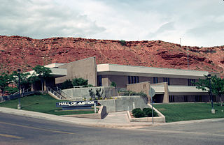
Washington County is a county in the southwestern corner of Utah, United States. As of the 2020 United States Census, the population was 180,279, making it the fifth-most populous county in Utah. Its county seat and largest city is St. George. The county was created in 1852 and organized in 1856. It was named after the first President of the United States, George Washington. A portion of the Paiute Indian Reservation is in western Washington County. Washington County comprises the St. George, UT Metropolitan Statistical Area.
Auberry is a census-designated place (CDP) in Fresno County, California, United States. The population was 2,369 at the 2010 census, up from 2,053 at the 2000 census. Auberry is located on Little Sandy Creek 9.5 miles (15 km) west of Shaver Lake Heights, at an elevation of 2,018 feet (615 m).
Price is a city in the U.S. state of Utah and the county seat of Carbon County. The city is home to Utah State University Eastern, as well as the USU Eastern Prehistoric Museum. Price is located within short distances of both Nine Mile Canyon and the Manti-La Sal National Forest.
Wellington is a city in Carbon County, Utah, United States. The population was 1,676 at the 2010 census. The community was settled in 1878 by a band of thirteen Mormons led by Jefferson Tidwell. The town was named for Justus Wellington Seeley, Jr., of the Emery County Court. Many residents commute to nearby Price for their jobs, or work in one of the various coal mines in the area.
Myton is a city in Duchesne County, Utah, United States. Established in 1905, Myton had a population of 569 at the 2010 census.
Kanarraville is a town in Iron County, Utah, United States. The population was 355 at the 2010 census.
Levan is a town in Juab County, Utah, United States. As of the 2020 census it had a population of 862.
Hinckley is a town in Millard County, Utah, United States, in the middle of the Sevier Desert. Irrigation water from the Sevier River, passing nearby, has been used to turn Hinckley into a farming oasis. The mountains that are common in Utah are seen only in the distance, and beyond the reach of the river, a severe desert prevails. The population was 696 at the 2010 census.
Ephraim is a city in Sanpete County, Utah, United States. The population was 5,611 at the 2020 census, making it the largest city in Sanpete County. It is the location of Snow College and is located along U.S. Route 89.
Aurora is a city in north-central Sevier County, Utah, United States. The population was 1,016 at the 2010 census.
Vernon is a town in southeastern Tooele County, Utah, United States.
Goshen is a town in Utah County, Utah, United States. It is part of the Provo–Orem Metropolitan Statistical Area. The population was 921 at the 2010 census.
Highland is a city in Utah County, Utah, United States. It is approximately 30 miles (48 km) south of Salt Lake City and is part of the Provo–Orem Metropolitan Statistical Area. According to the 2010 census the population was 15,523, a 90.0% increase over the 2000 figure of 8,172.
Hurricane is a city in Washington County, Utah, United States. Its population was 20,036 as of the 2020 United States Census estimates. The Hurricane valley makes up the easternmost part of the St. George Metropolitan area and is becoming a tourist gateway town to Zion National Park. Hurricane is known for its historic peach and pecan orchards, open space, green fields and small-town charm, although like much of southwestern Utah, the Hurricane valley continues to experience significant population growth.
New Harmony is a town in northern Washington County, Utah, United States. The population was 207 at the 2010 census.
Rockville is a town in Washington County, Utah, United States. It is located along the Virgin River near the mouth of Zion Canyon. The city lies just outside the park boundary for Zion National Park; the park entrance is located approximately 5 miles (8 km) northeast of the town.
Virgin is a town in Washington County, Utah, United States. The population was 596 at the 2010 census. The first settlement at Virgin was made in 1858. It is located along the Virgin River, and not far from Zion National Park. The elevation is 3,606 feet (1,099 m). It lies on State Route 9.
Uintah is a city in Weber County, Utah, United States. The population was 1,322 at the 2010 census. It is part of the Ogden–Clearfield, Utah Metropolitan Statistical Area. Although Uintah was a town in 2000, it has since been classified as a fifth-class city by state law.
Teays Valley is a census-designated place in Putnam County, West Virginia, United States. The population was 14,350 at the 2020 census. Located about 18 miles (29 km) west of Charleston and 28 miles (45 km) east of Huntington, it is part of the Huntington–Ashland metropolitan area.
Worland is a city in Washakie County, Wyoming, United States. The population was 5,487 at the 2010 census. It is the county seat of Washakie County. It is located within the Big Horn Basin and along the Big Horn River in northwestern Wyoming.