Vilas County is a county in the state of Wisconsin, United States. As of the 2020 census, the population was 23,047. Its county seat is Eagle River. The county partly overlaps the reservation of the Lac du Flambeau Band of Lake Superior Chippewa.

Ontonagon County is a county in the Upper Peninsula of the U.S. state of Michigan. As of the 2020 census, the population was 5,816, making it Michigan's third-least populous county. The county seat is Ontonagon. The county was set off in 1843, and organized in 1848. Its territory had been organized as part of Chippewa and Mackinac counties. With increasing population in the area, more counties were organized. After Ontonagon was organized, it was split to create Gogebic County. It is also the westernmost county in United States that lies within the Eastern Time Zone.

Gogebic County is a county in the Upper Peninsula of the U.S. state of Michigan. As of the 2020 census, the population was 14,380. The county seat is Bessemer. Gogebic County is the westernmost county in Michigan, and is one of four Michigan counties within the Central Time Zone. Gogebic County borders Wisconsin to the south, and has a shoreline on Lake Superior to the north.
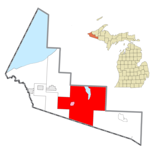
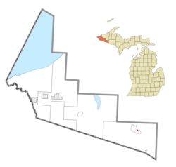
Marenisco Township is a civil township of Gogebic County in the U.S. state of Michigan. The population was 455 at the 2020 census, a significant decrease from 1,727 at the 2010 census.

Watersmeet Township is a civil township of Gogebic County in the Upper Peninsula of the U.S. state of Michigan. The population was 1,456 in 2020. Chippewa students made up half of the student body and winning high school basketball team in the early 2000s. It was featured in the 2007 documentary Nimrod Nation, shown on The Sundance Channel.

Land o' Lakes is a town in Vilas County, Wisconsin, United States. The population was 861 at the 2010 census. The unincorporated community of Land o' Lakes is located in the town.

Phelps is a town in Vilas County, Wisconsin, United States. The population was 1,238 in 2020. The unincorporated community of Phelps is located in the town.

The L'Anse Indian Reservation is the land base of the federally recognized Keweenaw Bay Indian Community of the historic Lake Superior Band of Chippewa Indians.. The reservation is located primarily in two non-contiguous sections on either side of the Keweenaw Bay in Baraga County in the Upper Peninsula of the U.S. state of Michigan. The Keweenaw Bay Community also manages the separate Ontonagon Indian Reservation.

The Lac du Flambeau Band of Lake Superior Chippewa is a federally recognized Ojibwa Native American tribe. It had 3,415 enrolled members as of 2010. The Lac du Flambeau Indian Reservation lies mostly in the Town of Lac du Flambeau in south-western Vilas County, and in the Town of Sherman in south-eastern Iron County in the U.S. state of Wisconsin. It has a land area of 107.1 square miles (277.4 km2) and a 2020 census resident population of 3,518 persons. Its major settlement is the unincorporated Lac du Flambeau, which had a population of 1,845 persons.

Marenisco is an unincorporated community and census-designated place (CDP) in Marenisco Township, Gogebic County, Michigan, in the United States. As of the 2010 census, the CDP had a population of 254, out of a total population in the township of 1,727. The name of the community and the township was formed by combining the first three letters from Mary Enid Scott, the wife of E. H. Scott, a timber producer.

Watersmeet is an unincorporated community and census-designated place (CDP) in Watersmeet Township, Michigan. As of the 2010 census, the CDP had a population of 428, out of a total population in the township of 1,417. The community was platted in 1884, designated as a station of the Milwaukee Lake Shore and Western Railroad.
Bois Forte Indian Reservation is an Indian reservation formed for the Bois Forte Band of Chippewa.
The Fond du Lac Indian Reservation is an Indian reservation in northern Minnesota near Cloquet in Carlton and Saint Louis counties. Off-reservation holdings are located across the state in Douglas County, in the northwest corner of Wisconsin. The total land area of these tribal lands is 154.49 square miles (400.1 km2). It is the land-base for the Fond du Lac Band of Lake Superior Chippewa. Before the establishment of this reservation, the Fond du Lac Band of Lake Superior Chippewa were located at the head of Lake Superior, closer to the mouth of the Saint Louis River, where Duluth has developed.
Mille Lacs Indian Reservation is the popular name for the land-base for the Mille Lacs Band of Ojibwe in Central Minnesota, about 100 miles (160 km) north of Minneapolis-St. Paul. The contemporary Mille Lacs Band reservation has significant land holdings in Mille Lacs, Pine, Aitkin and Crow Wing counties, as well as other land holdings in Kanabec, Morrison, and Otter Tail Counties. Mille Lacs Indian Reservation is also the name of a formal Indian reservation established in 1855. It is one of the two formal reservations on which the contemporary Mille Lacs Band retains land holdings. The contemporary Mille Lacs band includes several aboriginal Ojibwe bands and villages, whose members reside in communities throughout central Minnesota.
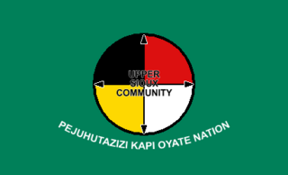
The Upper Sioux Indian Reservation, or Pezihutazizi in Dakota, is the reservation of the Upper Sioux Community, a federally recognized tribe of the Dakota people, that includes the Mdewakanton.

The Lac Courte Oreilles Tribe is one of six federally recognized bands of Ojibwe people located in present-day Wisconsin. It had 7,275 enrolled members as of 2010. The band is based at the Lac Courte Oreilles Indian Reservation in northwestern Wisconsin, which surrounds Lac Courte Oreilles. The main reservation's land is in west-central Sawyer County, but two small plots of off-reservation trust land are located in Rusk, Burnett, and Washburn counties. The reservation was established in 1854 by the second Treaty of La Pointe.
Lac Vieux Desert is a lake in the United States divided between Gogebic County, Michigan, and Vilas County, Wisconsin. Fed primarily by springs in the surrounding swamps, it is the source of the Wisconsin River, which flows out of its southwest corner. The lake contains a number of small islands, especially in its northeastern lobe, including Draper Island, in Michigan, and Duck Island, in Wisconsin.

The Hannahville Indian Community is a federally recognized Potawatomi tribe residing in Michigan's Upper Peninsula, approximately 15 miles (24 km) west of Escanaba on a 8.5755-square-mile (22.210 km2) reservation. The reservation, at 45°46′59″N87°25′23″W, lies mostly in Harris Township in eastern Menominee County, but a small part is located in northeastern Gourley Township, also in Menominee County, and another in Bark River Township in adjacent southwestern Delta County.

The Ottawa National Forest is a national forest that covers 993,010 acres (401,860 ha) in the Upper Peninsula of the U.S. state of Michigan. It includes much of Gogebic and Ontonagon counties, as well as slices of Iron, Houghton, Baraga, and Marquette counties. The forest is under the jurisdiction of the U.S. Forest Service.

Lac Vieux Desert Band of Lake Superior Chippewa is a band of the Lake Superior Chippewa, many of whom reside on the Lac Vieux Desert Indian Reservation, located near Watersmeet, Michigan. It is approximately 45 miles southeast of Ironwood, Michigan in Gogebic County.