Lake Waikaremoana

Last updated

Lake Waikaremoana
New Zealand, Great Walk Lake Waikaremoana (1).JPG
Lake Waikaremoana (winter 2015)
Lake Waikaremoana
NZ-NI plain map.png
Disc Plain red.svg
Lake Waikaremoana
Location Wairoa District, Hawke's Bay Region, North Island
Coordinates 38°46′S177°05′E / 38.767°S 177.083°E / -38.767; 177.083
Primary outflows Waikaretaheke River
Basin  countriesNew Zealand
Surface area54 km2 (21 sq mi)
Max. depth256 m (840 ft)
Shore length1102.3 km (63.6 mi)
Surface elevation600 m (2,000 ft)
Settlements Āniwaniwa
1 Shore length is not a well-defined measure.

Lake Waikaremoana is located in Te Urewera in the North Island of New Zealand, 60 kilometres northwest of Wairoa and 80 kilometres west-southwest of Gisborne. It covers an area of 54 km2 (21 sq mi). From the Māori Waikaremoana translates as 'sea of rippling waters'. [1]

Contents

The lake lies within the tribal boundaries of Ngāi Tūhoe, Ngāti Ruapani and Ngāti Kahungunu ki Te Wairoa. The hamlet of Aniwaniwa and the Waikaremoana Holiday Park are located on the lakeshore, along SH38 (from Wai-O-Tapu via Murupara to Wairoa), which connects the lake to the central North Island (Rotorua) and Gisborne. There is a Department of Conservation office at Aniwaniwa. Several walks start here, including a short stroll to Āniwaniwa Falls.

The village of Onepoto is located on the lake's southern shores, close to the lake's old overflow channel and the intake of the Waikaremoana hydroelectric power scheme. The name Onepoto means short beach , and refers to the small bay to the north of the village with a beach only 60 metres long. [2]

Lake Waikaremoana is a holiday destination for people who use the lake for fishing, tramping and other recreational activities. The Lake Waikaremoana Track, one of New Zealand's "Great Walks", is a three- to four-day tramp which follows approximately half of the lake's circumference. The track can be walked independently, or as part of a guided group. There are huts dotted on the walk which require booking to use. Camping is permitted unless you are more than 500 metres from the track.

The climate of the area is temperate In the summer and cool during the winters, snowfalls occur a few times a year in the region.

Numbers of visitors to the area are limited to some extent as a result of the extensive unsealed road that must be taken to reach it. This makes Lake Waikaremoana significantly less congested with tourists than the other nine Great Walks in New Zealand. The smaller Lake Waikareiti lies four kilometres to the northeast.

Geography, natural history and climate

Waikaremoana, the North Island's deepest lake (256 m deep), has its surface at 600 metres above sea level. A huge landslide dam about 250 metres high formed the lake around 2,200 years ago. [3] Before the landslip was sealed, around 1950, much of the lake outflow flowed through the landslip rather than out of an overflow at a low point in the slip. [3]

Other geographical features include Panekiri Bluff and Puketukutuku Peninsula, which is the site of a kiwi-conservation programme. Surrounded by mountains clad with native forest which has never been logged, Waikaremoana retains ecological importance. Many native bird-species scarce in most other parts of the North Island occur in the area. A possum-hunting programme operates in the area to help protect the forest. Numerous understory species grow within the forested area of the catchment basin, crown fern (Lomaria discolor), for example. [4] Since at least the early 1900s lake-bottom molluscs have been studied by Colenso (1811-1899) and others. [5]

The climate of Lake Waikaremoana is temperate during the summer months and cool in the winter where snow events are not unheard of. Heavy rains affect the region, especially about late winter and early spring. The weather in the area is very changeable, trampers in the region need to be on the look out for dangerous weather conditions.

Hydroelectric power scheme

Fisherman on the lake shore New Zealand, Great Walk Lake Waikaremoana (7).JPG
Fisherman on the lake shore

The Waikaremoana Hydroelectric Power Scheme is a rare example of a hydroelectric power station being built on a natural landslide dam. [6] [ page needed ] Another example is the Tortum Dam in Turkey. [ citation needed ]

Modifying the natural dam

The stability of the natural dam has been the subject of intense engineering review, both at the time of construction and subsequently. Construction of an outlet tunnel through the slip, which commenced in 1935, required extensive grouting around the control structures and throughout tunnel construction. Work was suspended at the end of 1936 because Bob Semple, the newly elected Minister for Public Works, wanted the tunnelling project reconsidered for "risk, cost and value". A new tunnelling scheme was devised in 1941 based on what had been learned from initial exploratory tunnelling and work recommenced in 1943 and continued for about 5 years because of continual problems with dewatering the tunnels. After the tunnels and intake headworks had been completed the natural dam was sealed for leaks on the lake side by removing submerged timber, a task that took a year and then applying 40,000 cubic metres of crushed rock and clay-like pumice in 6 layers, then covering those layers with a top layer of larger rock and spalls to protect the material from wave action. This sealing reduced the natural flow by about 80%. The sealing of the lake was only done after tunnelling was completed otherwise it would have caused the lake level to rise and make tunnelling more difficult. As it was, the lake level had to be lowered by temporary syphons to enable the construction of the headworks and make sealing of the natural dam easier. [3]

Power stations

Although the Waikaretaheke River carries a flow of about 17 m³/s from Lake Waikaremoana, the head of water through the 3 power stations, Kaitawa, Tuai, and Piripaua is around 450 metres, allowing the stations to potentially generate 138 megawatts all up. The 250m head of water for the Kaitawa station is the highest for a power station in New Zealand and among the highest in the world. [3]

See also

Related Research Articles

The East Cape War, sometimes also called the East Coast War, was a series of conflicts fought in the North Island of New Zealand from April 1865 to October 1866 between colonial and Māori military forces. At least five separate campaigns were fought in the area during a period of relative peace in the long-running 19th century New Zealand Wars.

<span class="mw-page-title-main">New Zealand tramping tracks</span>

In New Zealand, long distance walking or hiking for at least one overnight stay is known as tramping. There are a number of walkways in New Zealand, however most of these are relatively short and can be walked in a day or less. Many are also an easy walk, with well formed footpaths. However, some tracks require an overnight stay either because of the rugged country or the length of the track.

<span class="mw-page-title-main">Fiordland National Park</span> National park on South Island of New Zealand

Fiordland National Park is a national park in the south-west corner of South Island of New Zealand. It is the largest of the 13 national parks in New Zealand, with an area covering 12,607 km2 (4,868 sq mi), and a major part of the Te Wāhipounamu a UNESCO World Heritage Site established in 1990. The park is administered by the Department of Conservation. The southern ranges of the Southern Alps cover most of Fiordland National Park, combined with the deep glacier-carved valleys.

<span class="mw-page-title-main">Te Urewera National Park</span> Former National park of New Zealand

Te Urewera National Park was a national park near the east coast of New Zealand's North Island, established as such in 1954 and disestablished in 2014, when it was replaced by a new legal entity and protected area named Te Urewera. The park covered an area of approximately 2,127 km2 and was located in the north of the Hawke's Bay region of the North Island. It was the largest of four national parks in the North Island and the most isolated rainforest in the region.

<span class="mw-page-title-main">Rangitaiki River</span> River in New Zealand

The Rangitaiki River is the longest river in the Bay of Plenty region in New Zealand's North Island. It is 155 kilometres (96 mi) long, and rises inland from northern Hawkes Bay to the east of the Kaingaroa Forest. The Rangitaiki catchment covers an area of 3005 km2. It flows in a generally northeastward direction, passing through the town of Murupara and skirting close to the western edge of Te Urewera National Park before turning northwards, flowing past Edgecumbe and into the Bay of Plenty close to Thornton.

<span class="mw-page-title-main">Ruatāhuna</span> Place in Bay of Plenty, New Zealand

Ruatāhuna is a small town in the remote country of Te Urewera, in the northeast of New Zealand's North Island. It is 90 kilometres directly west of Gisborne, and 18 kilometres northwest of Lake Waikaremoana. By road, it is 50 kilometres south-east of Murupara, and 110 kilometres north-west of Wairoa. It is on the upper reaches of the Whakatāne River, and surrounded on three sides by the Te Urewera protected area, formerly the Te Urewera National Park. The road that runs from Murupara through Ruatahuna to Āniwaniwa on Lake Waikaremoana, a large part of which is unsealed, used to be designated as part of State Highway 38. It is a subdivision of the Galatea-Murupara ward of the Whakatāne District.

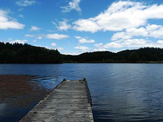
Lake Waikareiti, also spelt Lake Waikare Iti, is located in Te Urewera National Park in the North Island of New Zealand. A number of hiking trails are found within the catchment basin of the lake.

<span class="mw-page-title-main">Te Urewera</span>

Te Urewera is an area of mostly forested, sparsely populated rugged hill country in the North Island of New Zealand, a large part of which is within a protected area designated in 2014, that was formerly Te Urewera National Park.

<span class="mw-page-title-main">New Zealand Great Walks</span> Set of tramping tracks

The New Zealand Great Walks are a set of popular tramping tracks developed and maintained by the Department of Conservation. They are New Zealand's premier tracks, through areas of some of the best scenery in the country, ranging from coastlines with beaches to dense rain forests and alpine terrain. The tracks are maintained to a high standard, making it easier for visitors to explore some of the most scenic parts of New Zealand's backcountry.

<span class="mw-page-title-main">Lake Waikaremoana Great Walk</span> Hiking trail in New Zealands North Island

The Lake Waikaremoana Great Walk is a 44-kilometre (27 mi) tramping track which follows the southern and western coast of Lake Waikaremoana in the North Island of New Zealand. Passing through several types of forest, and grassland, the track often provides views over the lake. It is classified as one of New Zealand's Great Walks, and is located in the former Te Urewera National Park.

<span class="mw-page-title-main">Tungatinah Power Station</span> Power station in Tasmania, Australia

The Tungatinah Power Station is a conventional hydroelectric power station located in the Central Highlands region of Tasmania, Australia. The power station is situated on the Upper River Derwent catchment and is owned and operated by Hydro Tasmania.

Tiniroto is a small farming and forestry community on the “inland” road from Gisborne to Wairoa in the eastern part of the North Island of New Zealand.

<span class="mw-page-title-main">Wairoa River (Hawke's Bay)</span> River in New Zealand

The Wairoa River of the Hawke's Bay region in New Zealand runs south for 65 kilometres from the inland east coast region of the North Island, west of Gisborne, before flowing into northern Hawke Bay at the town of Wairoa.

A landslide dam or barrier lake is the natural damming of a river by some kind of landslide, such as a debris flow, rock avalanche or volcanic eruption. If the damming landslide is caused by an earthquake, it may also be called a quake lake. Some landslide dams are as high as the largest existing artificial dam.

Waiapu was a New Zealand parliamentary electorate in the Gisborne – East Coast Region of New Zealand, from 1893 to 1908.

<span class="mw-page-title-main">Hydroelectric power in New Zealand</span>

Hydroelectric power in New Zealand has been a part of the country's energy system for over 100 years and continues to provide more than half of the country's electricity needs. Hydroelectricity is the primary source of renewable energy in New Zealand. Power is generated the most in the South Island and is used most in the North Island.

<span class="mw-page-title-main">State Highway 38 (New Zealand)</span> Road in New Zealand

State Highway 38 is a road in the North Island of New Zealand that starts from SH 5 near Waiotapu, and ends at Wairoa, where it connects to SH 2. It is the shortest connection from the central North Island (Rotorua) to the East Coast (Gisborne), but it is not often used as such. Large parts of the road are narrow and winding, and about 74 kilometres (46 mi) of the road is unsealed. Travel on this highway takes roughly four hours.

<span class="mw-page-title-main">Lake Āniwaniwa</span> Lake in Bay of Plenty region, New Zealand

Lake Āniwaniwa is a small man-made lake on the Rangitaiki River, in the Bay of Plenty region of New Zealand. The lake is situated 13 km north of the town of Murupara, and about 16 km upstream of the Matahina Dam. The lake was created as a result of the construction of a 10 m high dam, part of the Aniwhenua hydroelectric scheme.

<span class="mw-page-title-main">Lake Gault</span> Small glacial lake in South Westland, New Zealand

Lake Gault is a small glacial lake in South Westland, New Zealand, near the township of Fox Glacier. A walking track from Lake Matheson leads to the lake, which is surrounded by mature native forest. A small hydro-electric power plant was constructed piping water from the lake to power a gold mining dredge at Gillespies Beach. Endangered Ōkārito kiwi (rowi) have been released into the wild around Lake Gault.

References

Line notes

  1. "1000 Māori place names". New Zealand Ministry for Culture and Heritage. 6 August 2019.
  2. Wises New Zealand Guide, 7th edition 1979
  3. 1 2 3 4 Offer, R.E. (Robert) (1997). Walls for Water: Pioneer Dam Building in New Zealand. Palmerston North: The Dunmore Press Ltd. pp. 191–200. ISBN   0-86469-313-3.
  4. C. Michael Hogan. 2009
  5. Royal Society of New Zealand. 1905
  6. Offer, R.E. (Robert) (1997). Walls for Water: Pioneer Dam Building in New Zealand. Palmerston North: The Dunmore Press Ltd. ISBN   978-0-86469-313-6.
Lake Waikaremoana.jpg
View of Lake Waikaremoana from Panekiri Bluff