Landmark

Last updated

An 18th-century painting of a ship with Table Mountain in the background, used by navigators as the landmark to sail around southern tip of Africa. Hodges cape-good-hope.jpg
An 18th-century painting of a ship with Table Mountain in the background, used by navigators as the landmark to sail around southern tip of Africa.

A landmark is a recognizable [1] natural or artificial feature used for navigation, a feature that stands out from its near environment and is often visible from long distances.

Contents

In modern day use, the term can also be applied to smaller structures or features, that have become local or national symbols.

Etymology

The Statue of Liberty (formally Liberty Enlightening the World), a famous landmark of New York City and United States, greets the newly arrived immigrants, located near Ellis Island where millions of immigrants first touched U.S. soil. Welcome to the land of freedom.png
The Statue of Liberty (formally Liberty Enlightening the World), a famous landmark of New York City and United States, greets the newly arrived immigrants, located near Ellis Island where millions of immigrants first touched U.S. soil.

In old English the word landmearc (from land + mearc (mark)) was used to describe a boundary marker, an "object set up to mark the boundaries of a kingdom, estate, etc.". [2] Starting from around 1560, this understanding of "landmark" was replaced by a more general one. A landmark became a "conspicuous object in a landscape".

A landmark literally meant a geographic feature used by explorers and others to find their way back or through an area. [3] For example, the Table Mountain near Cape Town, South Africa was used as a landmark to help sailors to navigate around the southern tip of Africa during the Age of Exploration. Artificial structures are also sometimes built to assist sailors in navigation. The Lighthouse of Alexandria and the Colossus of Rhodes are ancient structures built to lead ships to the port. In modern usage, a landmark includes anything that is easily recognizable, such as a monument, building, or other structure. In American English it is the main term used to designate places that might be of interest to tourists, due to notable physical features or historical significance. Landmarks in the British English sense are often used for casual navigation, such as giving directions. This is done in American English as well.[ citation needed ]

In urban studies as well as in geography, a landmark is furthermore defined as an external point of reference that helps orientation in a familiar or unfamiliar environment. [4] Landmarks are often used in verbal route instructions ("Turn left at the big church and then right over the bridge.")

Types

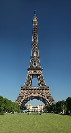
The Eiffel Tower - tallest in the world from 1889 to 1930 and a famous Paris landmark Tour Eiffel Wikimedia Commons.jpg
The Eiffel Tower - tallest in the world from 1889 to 1930 and a famous Paris landmark

Landmarks are usually classified as either natural landmarks or human-made landmarks, both are originally used to support navigation on finding directions. A variant is a seamark or daymark , a structure usually built intentionally to aid sailors navigating featureless coasts.

Natural

Natural landmarks can be characteristic features, such as mountains or plateaus. Examples of natural landmarks are Mount Everest in the Himalayas, Table Mountain in South Africa, Mount Ararat in Turkey, Uluru in Australia, Mount Fuji in Japan and the Grand Canyon in the United States. Trees might also serve as local landmarks, such as jubilee oaks or conifers. Some landmark trees may be named, such as Queen's Oak, Hanging Oak and Centennial Tree. Bases of fallen trees, known in this context as rootstocks, are used as navigational aids on high-resolution maps and in the sport of orienteering. [5] Because most woods have many fallen trees, generally only very large rootstocks are mapped.

Human made

In the modern sense, landmarks are usually referred to as monuments or prominent distinctive buildings, used as the symbol of a certain area, city, or nation. Some examples are the Statue of Unity in Narmada, the White House in Washington, D.C., the Statue of Liberty & One World Trade Center in New York City, the Eiffel Tower in Paris, Saint Basil's Cathedral in Moscow, the Lotte World Tower in Seoul, the Colosseum in Rome, Big Ben in London, the Tsūtenkaku in Osaka, the Forbidden City in Beijing, Christ the Redeemer in Rio de Janeiro, Bratislava Castle in Bratislava, Helsinki Cathedral in Helsinki, the Space Needle in Seattle, the Sydney Harbour Bridge or the Sydney Opera House (both in Sydney), the Brandenburg Gate in Berlin, the Château Frontenac in Quebec (city), Place Stanislas in Nancy, the CN Tower in Toronto, the Palace of Culture and Science in Warsaw, the Atomium in Brussels, Gateway Arch in St Louis, and the Moai in Easter Island. Church spires and mosque minarets are often very tall and visible from many miles around, and thus often serve as built landmarks. Also town hall towers and belfries often have a landmark character.

See also

Related Research Articles

<span class="mw-page-title-main">Cairn</span> Human-made pile of stones or burial monument

A cairn is a human-made pile of stones raised for a purpose, usually as a marker or as a burial mound. The word cairn comes from the Scottish Gaelic: càrn.

<span class="mw-page-title-main">Orienteering</span> Group of sports that requires navigational skills

Orienteering is a group of sports that involve using a map and compass to navigate from point to point in diverse and usually unfamiliar terrain whilst moving at speed. Participants are given a topographical map, usually a specially prepared orienteering map, which they use to find control points. Originally a training exercise in land navigation for military officers, orienteering has developed many variations. Among these, the oldest and the most popular is foot orienteering. For the purposes of this article, foot orienteering serves as a point of departure for discussion of all other variations, but almost any sport that involves racing against a clock and requires navigation with a map is a type of orienteering.

A waypoint is an intermediate point or place on a route or line of travel, a stopping point or point at which course is changed, the first use of the term tracing to 1880. In modern terms, it most often refers to coordinates which specify one's position on the globe at the end of each "leg" (stage) of an air flight or sea passage, the generation and checking of which are generally done computationally.

<span class="mw-page-title-main">Tower</span> Structure with height greater than width

A tower is a tall structure, taller than it is wide, often by a significant factor. Towers are distinguished from masts by their lack of guy-wires and are therefore, along with tall buildings, self-supporting structures.

Piloting or pilotage is the process of navigating on water or in the air using fixed points of reference on the sea or on land, usually with reference to a nautical chart or aeronautical chart to obtain a fix of the position of the vessel or aircraft with respect to a desired course or location. Horizontal fixes of position from known reference points may be obtained by sight or by radar. Vertical position may be obtained by depth sounder to determine depth of the water body below a vessel or by altimeter to determine an aircraft's altitude, from which its distance above the ground can be deduced. Piloting a vessel is usually practiced close to shore or on inland waterways. Pilotage of an aircraft is practiced under visual meteorological conditions for flight.

<span class="mw-page-title-main">Sea mark</span> Maritime navigation aid

A sea mark, also seamark and navigation mark, is a form of aid to navigation and pilotage that identifies the approximate position of a maritime channel, hazard, or administrative area to allow boats, ships, and seaplanes to navigate safely.

<span class="mw-page-title-main">Trail blazing</span> Practice of marking footpaths by leaving signs that indicate the route

Trail blazing or way marking is the practice of marking paths in outdoor recreational areas with signs or markings that follow each other at certain, though not necessarily exactly defined, distances and mark the direction of the trail.

<span class="mw-page-title-main">Wayfinding</span> Ways in which people navigate from place to place

Wayfinding encompasses all of the ways in which people orient themselves in physical space and navigate from place to place. Wayfinding software is a self-service computer program that helps users to find a location, usually used indoors and installed on interactive kiosks or smartphones.

<span class="mw-page-title-main">Axis mundi</span> The world center in some religions and philosophies, as the connection between Heaven and Earth

In astronomy, axis mundi is the Latin term for the axis of Earth between the celestial poles.

<span class="mw-page-title-main">Observation tower</span> Architectural structure

An observation tower is a structure used to view events from a long distance and to create a full 360 degree range of vision to conduct long distance observations. Observation towers are usually at least 20 metres (66 ft) tall and are made from stone, iron, and wood. Many modern towers are also used as TV towers, restaurants, or churches. The towers first appeared in the ancient world, as long ago as the Babylonian Empire.

<span class="mw-page-title-main">Laurel wreath</span> Wreath made of branches and leaves of the bay laurel

A laurel wreath is a round wreath made of connected branches and leaves of the bay laurel, an aromatic broadleaf evergreen, or later from spineless butcher's broom or cherry laurel. It is a symbol of triumph and is worn as a chaplet around the head, or as a garland around the neck.

<span class="mw-page-title-main">Diver navigation</span> Underwater navigation by scuba divers

Diver navigation, termed "underwater navigation" by scuba divers, is a set of techniques—including observing natural features, the use of a compass, and surface observations—that divers use to navigate underwater. Free-divers do not spend enough time underwater for navigation to be important, and surface supplied divers are limited in the distance they can travel by the length of their umbilicals and are usually directed from the surface control point. On those occasions when they need to navigate they can use the same methods used by scuba divers.

<span class="mw-page-title-main">Fire lookout tower</span> Building to house a person who watches for wildfires

A fire lookout tower, fire tower, or lookout tower is a tower that provides housing and protection for a person known as a "fire lookout", whose duty it is to search for wildfires in the wilderness. It is a small building, usually on the summit of a mountain or other high vantage point to maximize viewing distance and range, known as view shed. From this vantage point the fire lookout can see smoke that may develop, determine the location by using a device known as an Osborne Fire Finder, and call for wildfire suppression crews. Lookouts also report weather changes and plot the location of lightning strikes during storms. The location of the strike is monitored for a period of days afterwards, in case of ignition.

<span class="mw-page-title-main">Daymark</span> Daytime aid to navigation

A daymark is a navigational aid for sailors and pilots, distinctively marked to maximize its visibility in daylight.

<span class="mw-page-title-main">Mounted orienteering</span>

Mounted orienteering is the practice of orienteering while riding a horse or other riding animal.

<span class="mw-page-title-main">Ski orienteering</span> Winter sport combining cross-country skiing with orienteering

Ski orienteering (SkiO) is a cross-country skiing endurance winter racing sport and one of the four orienteering disciplines recognized by the IOF. A successful ski orienteer combines high physical endurance, strength and excellent technical skiing skills with the ability to navigate and make the best route choices while skiing at a high speed.

<span class="mw-page-title-main">Orienteering map</span>

An orienteering map is a map specially prepared for use in orienteering events. It is a large-scale topographic map with extra markings to help the participant navigate through the course.

<span class="mw-page-title-main">Control point (orienteering)</span> Waypoint in adventure sports

A control point is a marked waypoint used in orienteering and related sports such as rogaining and adventure racing. It is located in the competition area; marked both on an orienteering map and in the terrain, and described on a control description sheet. The control point must be identifiable on the map and on the ground. A control point has three components: a high visibility item, known as a flag or kite; an identifier, known as a control code; and a recording mechanism for contestants to record proof that they visited the control point. The control point is usually temporary, except on a permanent orienteering course.

<span class="mw-page-title-main">Mountain bike orienteering</span>

Mountain bike orienteering is an orienteering endurance racing sport on a mountain bike where navigation is done along trails and tracks. Compared with foot orienteering, competitors usually are not permitted to leave the trail and track network. Navigation tactics are similar to ski-orienteering, where the major focus is route choice while navigating. The main difference compared to ski-orienteering is that navigation is done at a higher pace, because the bike can reach higher speeds. As the biker reaches higher speeds, map reading becomes more challenging.

A rootstock is part of a plant, often an underground part, from which new above-ground growth can be produced.

References

  1. "LANDMARK | meaning in the Cambridge English Dictionary". dictionary.cambridge.org. Retrieved 2 August 2020.
  2. "Online Etymology Dictionary". Etymonline.com. Retrieved 25 January 2016.
  3. "Landmarker".
  4. Lynch, Kevin. "The image of the city". MIT Press, 1960, p. 48
  5. International Specification for Control Descriptions. International Orienteering Federation. 2018.