British Columbia Ferry Services Inc., operating as BC Ferries (BCF), is a former provincial Crown corporation, now operating as an independently managed, publicly owned Canadian company. BC Ferries provides all major passenger and vehicle ferry services for coastal and island communities in the Canadian province of British Columbia. Set up in 1960 to provide a similar service to that provided by the Black Ball Line and the Canadian Pacific Railway, which were affected by job action at the time, BC Ferries has become the largest passenger ferry line in North America, operating a fleet of 41 vessels with a total passenger and crew capacity of over 27,000, serving 47 locations on the B.C. coast.
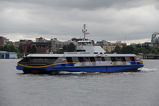
The SeaBus is a passenger-only ferry service in Metro Vancouver, British Columbia, Canada. It crosses Burrard Inlet to connect the cities of Vancouver and North Vancouver. Owned by TransLink and operated by the Coast Mountain Bus Company, the SeaBus forms an important part of the region's integrated public transportation system. In 2022, the SeaBus had a ridership of 4,245,700, or about 16,900 per weekday as of the third quarter of 2023.
British Columbia Highway 101, also known as the Sunshine Coast Highway, is the main north–south thoroughfare on the Sunshine Coast, British Columbia, Canada.

The C-class ferries are a class of five double-ended roll-on/roll-off ferries operated by BC Ferries in the Strait of Georgia in British Columbia, constructed between 1976 and 1981. When the vessels were first built, they were the largest ships of their kind in the world. The C-class ferries are 139.29 m (457.0 ft) long, with a car capacity of 316, and a crew and passenger capacity of 1494 persons. Each vessel's two MaK 12M551AK engines produce 11,860 HP, which provides a maximum service speed of 20.5 knots.

MV Queen of Coquitlam is a C-class ferry in the BC Ferries fleet, launched in 1976. She first operated on BC Ferries' Horseshoe Bay to Departure Bay route. For most of her life, she has been a replacement/relief vessel on all the major routes serving Metro Vancouver. She is named for the city of Coquitlam.
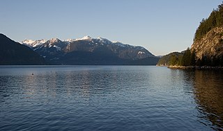
Howe Sound is a roughly triangular sound, that joins a network of fjords situated immediately northwest of Vancouver, British Columbia, Canada. It was designated as a UNESCO Biosphere Reserve in 2021.

Plumper Cove Marine Provincial Park is a provincial park in British Columbia, Canada. The park is located on Keats Island in Howe Sound, northwest of Vancouver, British Columbia.

MV Queen of Surrey is a double-ended C-class roll-on/roll-off ferry in the BC Ferries fleet. The ship was launched in 1980 and entered service in 1981. The ferry normally operates on BC Ferries' Horseshoe Bay to Langdale route. She is named for the city of Surrey. On May 12, 2003, Queen of Surrey suffered an engine fire that disabled the ferry in Howe Sound. No one was injured and the ship was returned to service. In 2004, the ferry was involved in a collision with a tugboat, and in 2019 she struck a fixed structure at the Langdale terminal. The 2019 crash lead to passengers being stranded on the vessel for over ten hours.
Gambier Island is an island located in Howe Sound near Vancouver, British Columbia. It is about 17,049 acres in size and is located about 10 kilometres north of the Horseshoe Bay community and ferry terminal in westernmost West Vancouver.

Langdale is a small residential community in British Columbia, Canada, located within the territory of the Squamish Nation, and part of West Howe Sound, Electoral Area F within the Sunshine Coast Regional District (SCRD).
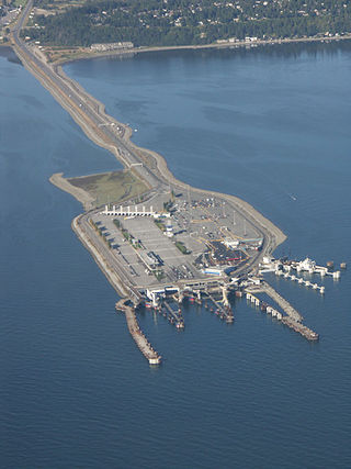
Tsawwassen is a ferry terminal and a major transportation facility in Delta, British Columbia, part of the BC Ferries system and Highway 17. Positioned less than 500 metres (1,600 ft) from the 49th parallel along the Canada–United States border, it is located at the southwestern end of a 2-kilometre (1 mi) causeway that juts out into the Strait of Georgia off the mainland at the community of Tsawwassen. With an approximate size of 23 hectares, it is the largest ferry terminal in North America.

Swartz Bay is a 22.7 ha (56.1-acre) ferry terminal and a major transportation facility at Swartz Bay in North Saanich, British Columbia. It is located 32 km (20 mi) north of Victoria on Vancouver Island. The terminal is part of the BC Ferries system, as well as part of Highway 17.

Keats Island is an inhabited island located in Howe Sound near Vancouver, British Columbia. Around eighty people live on Keats Island year-round.

MV Malaspina Sky is an Intermediate-class ferry in the BC Ferries fleet built in 2008.

Horseshoe Bay is a major ferry terminal owned and operated by BC Ferries in British Columbia, Canada. Located in the community of Horseshoe Bay, a neighbourhood of West Vancouver, the terminal provides a vehicle ferry link from the Lower Mainland to Vancouver Island, the Sunshine Coast, and to Bowen Island, a small island in the southern part of Howe Sound.

Duke Point is a major ferry terminal owned and operated by BC Ferries that provides ferry service across the Strait of Georgia to Tsawwassen. The ferry terminal is located at Duke Point in Nanaimo and is the only major terminal in the BC Ferries system without a public transit connection.
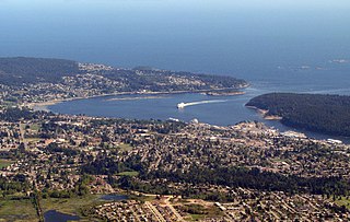
Departure Bay is a major ferry terminal in Nanaimo, British Columbia, owned and operated by BC Ferries that provides ferry service across the Strait of Georgia to Horseshoe Bay in West Vancouver. The terminal is located at the southern end of Departure Bay.

Bear Cove is a northern Vancouver Island ferry port in British Columbia, Canada. The location on the Queen Charlotte Strait, near the district municipality of Port Hardy in the Regional District of Mount Waddington, provides connections to British Columbia's Central and Northern coasts. The tidal range of the Queen Charlotte Strait is normally between 2 and 6 metres (7–20 ft). The ferry terminal is the northern terminus of Highway 19.

Westview is a ferry terminal in Powell River, British Columbia, Canada. It is located on Malaspina Strait, part of the Strait of Georgia, on the northern Sunshine Coast and provides connections to Texada Island and Vancouver Island. The ferry port is connected to Highway 101 via a short access road.

Nanaimo Harbour, highly associated with and commonly referred to as the "Gabriola Island Ferry", is a ferry terminal owned and operated by BC Ferries in British Columbia that goes from downtown Nanaimo across the Northumberland Channel to Descanso Bay on Gabriola Island. The route is serviced by two ferries, the MV Island Gwawis and the MV Island Kwigwis, which can hold up to 47 cars and 450 passengers with a total travel time of about 20 to 25 minutes.
