A biome is a distinct geographical region with specific climate, vegetation, and animal life. It consists of a biological community that has formed in response to its physical environment and regional climate. Biomes may span more than one continent. A biome encompasses multiple ecosystems within its boundaries. It can also comprise a variety of habitats.
The Global 200 is the list of ecoregions identified by the World Wide Fund for Nature (WWF), the global conservation organization, as priorities for conservation. According to WWF, an ecoregion is defined as a "relatively large unit of land or water containing a characteristic set of natural communities that share a large majority of their species dynamics, and environmental conditions". For example, based on their levels of endemism, Madagascar gets multiple listings, ancient Lake Baikal gets one, and the North American Great Lakes get none.

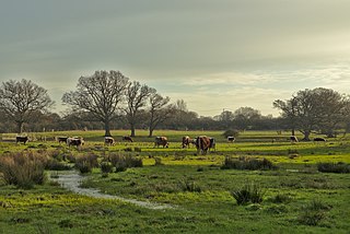
A grassland is an area where the vegetation is dominated by grasses (Poaceae). However, sedge (Cyperaceae) and rush (Juncaceae) can also be found along with variable proportions of legumes, like clover, and other herbs. Grasslands occur naturally on all continents except Antarctica and are found in most ecoregions of the Earth. Furthermore, grasslands are one of the largest biomes on Earth and dominate the landscape worldwide. There are different types of grasslands: natural grasslands, semi-natural grasslands, and agricultural grasslands. They cover 31–69% of the Earth's land area.

A savanna or savannah is a mixed woodland-grassland ecosystem characterised by the trees being sufficiently widely spaced so that the canopy does not close. The open canopy allows sufficient light to reach the ground to support an unbroken herbaceous layer consisting primarily of grasses. According to Britannica, there exists four savanna forms; savanna woodland where trees and shrubs form a light canopy, tree savanna with scattered trees and shrubs, shrub savanna with distributed shrubs, and grass savanna where trees and shrubs are mostly nonexistent.

Rangelands are grasslands, shrublands, woodlands, wetlands, and deserts that are grazed by domestic livestock or wild animals. Types of rangelands include tallgrass and shortgrass prairies, desert grasslands and shrublands, woodlands, savannas, chaparrals, steppes, and tundras. Rangelands do not include forests lacking grazable understory vegetation, barren desert, farmland, or land covered by solid rock, concrete and/or glaciers.

The Last Glacial Maximum (LGM), also referred to as the Last Glacial Coldest Period, was the most recent time during the Last Glacial Period where ice sheets were at their greatest extent 26,000 and 20,000 years ago. Ice sheets covered much of Northern North America, Northern Europe, and Asia and profoundly affected Earth's climate by causing a major expansion of deserts, along with a large drop in sea levels.

The Holarctic realm is a biogeographic realm that comprises the majority of habitats found throughout the continents in the Northern Hemisphere. It corresponds to the floristic Boreal Kingdom. It includes both the Nearctic zoogeographical region, and Alfred Wallace's Palearctic zoogeographical region.
In biology, a refugium is a location which supports an isolated or relict population of a once more widespread species. This isolation (allopatry) can be due to climatic changes, geography, or human activities such as deforestation and overhunting.

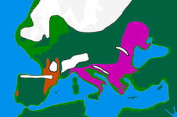
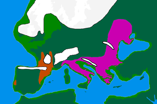
During the Last Glacial Maximum, the mammoth steppe, also known as steppe-tundra, was once the Earth's most extensive biome. It stretched east-to-west, from the Iberian Peninsula in the west of Europe, across Eurasia to North America, through Beringia and Canada; from north-to-south, the steppe reached from the arctic islands southward to China. The mammoth steppe was cold and dry, and relatively featureless, though topography and geography varied considerably throughout. Some areas featured rivers which, through erosion, naturally created gorges, gulleys, or small glens. The continual glacial recession and advancement over millennia contributed more to the formation of larger valleys and different geographical features. Overall, however, the steppe is known to be flat and expansive grassland. The vegetation was dominated by palatable, high-productivity grasses, herbs and willow shrubs.
The Late Glacial Interstadial (LGI) c. 14,670 to c. 12,890 BP, also called the Bølling–Allerød interstadial, represents the first pronounced warming since the end of the Last Glacial Maximum (LGM). Human populations, which had previously been forced into refuge areas, gradually begin to repopulate the Northern Hemisphere's Eurasian landmass.

A forest steppe is a temperate-climate ecotone and habitat type composed of grassland interspersed with areas of woodland or forest.

The Holdridge life zones system is a global bioclimatic scheme for the classification of land areas. It was first published by Leslie Holdridge in 1947, and updated in 1967. It is a relatively simple system based on few empirical data, giving objective criteria. A basic assumption of the system is that both soil and the climax vegetation can be mapped once the climate is known.

Montane ecosystems are found on the slopes of mountains. The alpine climate in these regions strongly affects the ecosystem because temperatures fall as elevation increases, causing the ecosystem to stratify. This stratification is a crucial factor in shaping plant community, biodiversity, metabolic processes and ecosystem dynamics for montane ecosystems. Dense montane forests are common at moderate elevations, due to moderate temperatures and high rainfall. At higher elevations, the climate is harsher, with lower temperatures and higher winds, preventing the growth of trees and causing the plant community to transition to montane grasslands and shrublands or alpine tundra. Due to the unique climate conditions of montane ecosystems, they contain increased numbers of endemic species. Montane ecosystems also exhibit variation in ecosystem services, which include carbon storage and water supply.
The northern and southern hemispheres of the earth have a dynamic history of advancing and retreating ice sheets. The glacial and interglacial periods are linked to regular eccentricities in the Earth's orbit and correspond to approximately 100 kyr cycles. The advancing, or glacial periods can cause a massive displacement of flora and fauna as it drives them away from the poles, with the most recent glacial maximum having occurred about 20,000 years ago.,
Vegetation classification is the process of classifying and mapping the vegetation over an area of the Earth's surface. Vegetation classification is often performed by state based agencies as part of land use, resource and environmental management. Many different methods of vegetation classification have been used. In general, there has been a shift from structural classification used by forestry for the mapping of timber resources, to floristic community mapping for biodiversity management. Whereas older forestry-based schemes considered factors such as height, species and density of the woody canopy, floristic community mapping shifts the emphasis onto ecological factors such as climate, soil type and floristic associations. Classification mapping is usually now done using geographic information systems (GIS) software.
A glacial refugium is a geographic region which made possible the survival of flora and fauna during ice ages and allowed for post-glacial re-colonization. Different types of glacial refugia can be distinguished, namely nunatak, peripheral, and lowland. Glacial refugia have been suggested as a major cause of floral and faunal distribution patterns in both temperate and tropical latitudes. With respect to disjunct populations of modern-day species, especially in birds, doubt has been cast on the validity of such inferences, as much of the differentiation between populations observed today may have occurred before or after their restriction to refugia. In contrast, isolated geographic locales that host one or more critically endangered species are generally uncontested as bona fide glacial refugia.

Changing climate conditions are amplified in polar regions and northern high-latitude areas are projected to warm at twice the rate of the global average. These modifications result in ecosystem interactions and feedbacks that can augment or mitigate climatic changes. These interactions may have been important through the large climate fluctuations since the glacial period. Therefore it is useful to review the past dynamics of vegetation and climate to place recent observed changes in the Arctic into context. This article focuses on northern Alaska where there has been much research on this theme.
The wood-pasture hypothesis is a scientific hypothesis positing that open and semi-open pastures and wood-pastures formed the predominant type of landscape in post-glacial temperate Europe, rather than the common belief of primeval forests. The hypothesis proposes that such a landscape would be formed and maintained by large wild herbivores. Although others, including landscape ecologist Oliver Rackham, had previously expressed similar ideas, it was the Dutch researcher Frans Vera, who, in his 2000 book Grazing Ecology and Forest History, first developed a comprehensive framework for such ideas and formulated them into a theorem. Vera's proposals, although highly controversial, came at a time when the role grazers played in woodlands was increasingly being reconsidered, and are credited for ushering in a period of increased reassessment and interdisciplinary research in European conservation theory and practice. Although Vera largely focused his research on the European situation, his findings could also be applied to other temperate ecological regions worldwide, especially the broadleaved ones.