Lauriston Castle, Aberdeenshire

Last updated

Lauriston Castle
St Cyrus, Scotland
NO761666
Lauriston Castle Aberdeenshire 1.JPG
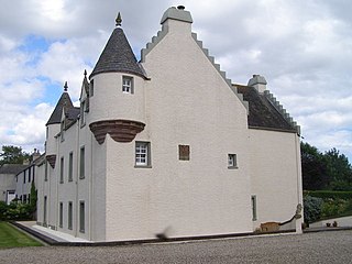
Lauriston Castle from the south
TypeCourtyard castle with later additions
Site information
OwnerPrivate
Open to
the public
Not open to public
Site history
Built13th century onwards
In use13th century onwards

Lauriston Castle stands on a clifftop site near the Aberdeenshire village of St Cyrus and just over a mile inland from the North Sea coast of Scotland. Once a royal fortress, it can claim to be one of the oldest privately owned and inhabited castles in the region. It is a Category C listed building. [1]

By tradition, it was the stronghold of Giric, Grig or Gregory the Great, one of the last of the Pictish kings (AD 878–889). The site of his church of Ecclesgreig (Eglise Grig) is nearby and he gave his Latin name, Ciricius, to St. Cyrus. [2]

Lauriston’s first charter is dated 1243 and it soon developed into a classic courtyard castle which was savagely fought over during Scotland's Wars of Independence and strengthened by King Edward III in 1336 as part of the chain of strongholds which he hoped would prevent a French landing in support of the Scots.

One of the corner towers on the edge of the cliff was incorporated into a typical laird’s house in the 1500s. In turn, this house was absorbed into a very large Georgian mansion of Palladian design, dated 1765–89.

For nearly 450 years Lauriston was held by the Stratons, whose arms of 1292 are among the earliest recorded in Scotland. [3] The eloquent Declaration of Arbroath, the famous letter of 1320 to Pope John XXII, sealed by the nation’s earls and barons, has as its final signatory the name of Alexander Straton.

Another Straton, the “noble knicht o’ Lauriston”, fell at the Battle of Harlaw in 1411, and shortly afterwards his son was involved in the affair of the Sheriff’s Kettle. The barons of the Mearns had been complaining about the high-handed behaviour of John Melville of Glenbervie, Sheriff of Kincardineshire, and King James’s Regent, the Duke of Albany, exclaimed in exasperation that he would not mind if they "biled the loon and suppit the bree". Taking this as royal licence, a group of barons lured Melville to a hunting party, tipped him into a cauldron or kettle of boiling water and, to seal the conspiracy, supped the broth. [4]

The Stratons continued, however, to prosper at Lauriston, even surviving the events of 1534, when David Straton fell out with the Church over payment of tithes on the salmon fishery. He objected to giving every tenth fish to the Abbot of Arbroath and told “his servants to cast the tenth fish into the sea againe", saying that God could catch his own. For this evasion of Church taxes he was taken to Edinburgh and condemned to death, thus becoming one of Scotland's first Protestant martyrs. [5]

In 1695, the Stratons were forced to sell Lauriston. Under the charter to the new owner, Court of Session Judge, Sir James Falconer of Phesdo, the estate became a burgh of barony, with a freeport at Miltonhaven. [6] [7] The name of the barony was also changed to Miltonhaven, but storms in the 1790s swept away both the port and village, leaving Lauriston to be known as “The Drown’d Barony”. Over the following century, the policies were developed in fashionable Picturesque style, with waterfalls, walks and a two-acre walled garden.

Following its use as RAF barracks during World War II, part of the mansion was demolished, and according to Nigel Tranter, the castle had “fallen on evil days indeed”. [8] [9]

Lauriston's Great Hall and Doocot Tower were rebuilt in the late 1980s by William and Dorothy Newlands of Lauriston to plans drawn up by architect Ian Begg. [10] The doocot received a Glenfiddich Living Scotland Award in 1992.

Related Research Articles

<span class="mw-page-title-main">William the Lion</span> King of Scotland from 1165 to 1214

William the Lion, sometimes styled William I and also known by the nickname Garbh, 'the Rough',, reigned as King of Scots from 1165 to 1214. His 48-year-long reign was the second longest in Scottish history, and the longest for a Scottish monarch before the Union of the Crowns in 1603.

<span class="mw-page-title-main">Clan Campbell</span> Highland Scottish clan

Clan Campbell is a Highland Scottish clan, historically one of the largest and most powerful of the Highland clans. The Clan Campbell lands are in Argyll and within their lands lies Ben Cruachan. The chief of the clan became Earl of Argyll and later Duke of Argyll.

<span class="mw-page-title-main">Clan Arbuthnott</span> Lowland Scottish clan

Clan Arbuthnott is a Lowland Scottish clan.

<span class="mw-page-title-main">George Heriot's School</span> School in Edinburgh, Scotland

George Heriot's School is a private primary and secondary day school on Lauriston Place in the Lauriston area of Edinburgh, Scotland. In the early 21st century, it has more than 1600 pupils, 155 teaching staff, and 80 non-teaching staff. It was established in 1628 as George Heriot's Hospital, by bequest of the royal goldsmith George Heriot, and opened in 1659. It is governed by George Heriot's Trust, a Scottish charity.

<span class="mw-page-title-main">Monboddo House</span> Historic structure in Scotland

Monboddo House is a historically famous mansion in The Mearns, Scotland. The structure was generally associated with the Burnett of Leys family. The property itself was owned by the Barclay family from the 13th century, at which time a tower house structure was erected. In 1593, the Laird was James Strachan, and thence it passed into the Irvine family and thereafter the Burnetts of Leys. There is a notable datestone adornment on the structure with the arms of Irvine impaling the arms of Douglas with initials R.E. and I.E. and dated 1635, representing the 17th-century couple who reconstructed the house, Robert Ervine and Ilizabeth Ervine. Monboddo House, with its crow-stepped gable design, is situated in the Howe of Mearns near the village of Auchenblae approximately nine miles (14 km) from the North Sea. The original landholding of the Monboddo Estate was approximately 200 square kilometres (77 sq mi).

<span class="mw-page-title-main">Clan Leslie</span> Lowland Scottish clan

Clan Leslie is a Lowland Scottish clan. The progenitor of the Clan, Bartolf, was a nobleman from Hungary, who came to Scotland in 1067. He built a castle at Lesselyn, from which the clan name derives.

<span class="mw-page-title-main">Clan Guthrie</span> Scottish clan

Clan Guthrie is a Scottish clan.

<span class="mw-page-title-main">Clan Ogilvy</span> Highland Scottish clan

Clan Ogilvy, also known as Clan Ogilvie, is a Highland Scottish clan. Originating from Angus, Scotland, the progenitor of the Clan received a barony from King William the Lion in 1163. In 1491, King James IV elevated Sir James Ogilvy as Lord Ogilvy of Airlie.

<span class="mw-page-title-main">Clan Forrester</span> Lowland Scottish clan

The Forresters are an ancient and noble clan of the Scottish Lowlands.

<span class="mw-page-title-main">Clan Strachan</span> Scottish clan

Clan Strachan is a Scottish clan originating from the barony of Strachan, in Aberdeenshire. The clan does not have a chief, therefore it is considered by Court of the Lord Lyon and the Stand Council of Scottish Chiefs as an Armigerous clan.

Clan Straiton, also called Straton or Stratton, is a Lowland Scottish clan. The clan does not currently have a chief therefore it is considered an Armigerous clan.

<span class="mw-page-title-main">Clan Swinton</span> Lowland Scottish clan

Clan Swinton is a Scottish clan of the Scottish Lowlands.

<span class="mw-page-title-main">Finavon Castle</span>

Finavon Castle lies on the River South Esk, about a quarter of a mile south of Milton of Finavon village and five miles to the north-east of Forfar in Angus, Scotland. The name is applied both to a ruined 17th-century castle, as well as the 19th-century mansion house 130m to the west.

A moot hill or mons placiti is a hill or mound historically used as an assembly or meeting place, as a moot hall is a meeting or assembly building, also traditionally to decide local issues. In early medieval Britain, such hills were used for "moots", meetings of local people to settle local business. Among other things, proclamations might be read; decisions might be taken; court cases might be settled at a moot. Although some moot hills were naturally occurring features or had been created long before as burial mounds, others were purpose-built.

Kilmaurs Place, The Place or Kilmaurs House, is an old mansion house and the ruins of Kilmaurs Tower grid reference NS41234112 are partly incorporated, Kilmaurs, East Ayrshire, Scotland. The house stands on a prominence above the Carmel Water and has a commanding view of the surrounding area. Once the seat of the Cunningham Earls of Glencairn it ceased to be the main residence after 1484 when Finlaystone became the family seat. Not to be confused with Kilmaurs Castle that stood on the lands of Jocksthorn Farm.

<span class="mw-page-title-main">Cartsburn</span>

The barony of Cartsburn in the Baronage of Scotland was created for Thomas Crawfurd of Cartsburn in 1669, when the lands of Cartsburn in the Parish of Easter Greenock in the Shire of Renfrew were erected in liberam baroniam, as a free barony held of the Prince and Great Steward of Scotland. The estate of Cartsburn, also known as Crawfurdsburn, incorporated the lands of Cartsdyke and part of the lands of Easter Greenock Castle. The Barony of Cartsburn is a feudal Barony of Scotland. The seat of the Barony was the House of Cartsburn, built in the 17th century near Greenock, Renfrewshire.

<span class="mw-page-title-main">Ninestane Rig</span>

Ninestane Rig is a small stone circle in Scotland near the English border. Located in Roxburghshire, near to Hermitage Castle, it was probably made between 2000 BC and 1250 BC, during the Late Neolithic or early Bronze Age. It is a scheduled monument and is part of a group with two other nearby ancient sites, these being Buck Stone standing stone and another standing stone at Greystone Hill. Settlements appear to have developed in the vicinity of these earlier ritual features in late prehistory and probably earlier.

The Sheriff of Kincardine, also known as The Mearns, was historically a royal appointment, held at pleasure, which carried the responsibility for enforcing justice in Kincardine, Scotland. Prior to 1748 most sheriffdoms were held on a hereditary basis. From that date, following the Jacobite uprising of 1745, the hereditary sheriffs were replaced by salaried sheriff-deputes, qualified advocates who were members of the Scottish Bar.

<span class="mw-page-title-main">Cavers Castle</span> Ruined tower house in Scottish Borders, Scotland, UK

Cavers Castle, also known as Cavers House, is a ruined tower house located at Cavers, Scottish Borders, Scotland. Cavers Castle was a much extended tower house of the Douglas family dating back to the 15th or 16th century, and built upon the site of an earlier stronghold of the Balliols. It was repeatedly attacked during the 16th century wars with England, and substantially remodelled in the 17th century to form a mansion house, itself extended and remodelled in baronial style by Peddie and McKay in the 1890s. It was eventually deroofed and partially demolished in the 1950s, and was sold most recently in 2019. There are developing plans to restore the building, which is a listed building.

References

  1. Historic Environment Scotland. "Lauriston Castle (Category C Listed Building) (LB16324)" . Retrieved 12 April 2019.
  2. History of Scotland, Duncan Keith, 1886.
  3. Scottish Arms, R.R. Stodart, 1881.
  4. Minstrelsy of the Scottish Border, Sir Walter Scott, 1803/4.
  5. The Martyrs of Angus and Mearns, J.Moffat Scott, 1885.
  6. The Records of the Parliaments of Scotland to 1707, K.M. Brown et al eds (St Andrews, 2007-2009), 1695/5/294. http://www.rps.ac.uk/trans/1695/5/294
  7. A Vision of Britain Through Time, Great Britain Historical GIS Project, http://www.visionofbritain.org.uk/unit/10361084
  8. The Fortified House in Scotland (Vol.4), Nigel Tranter, 1986.
  9. Portrait of a Parish, Duncan Fraser, 1979.
  10. Deeside and the Mearns, An Illustrated Architectural Guide, Jane Geddes, 2001, Rutland Press (Royal Incorporation of Architects in Scotland).

56°47′23″N2°23′44″W / 56.7896°N 2.3955°W / 56.7896; -2.3955