Layerthorpe

Last updated

Layerthorpe
York MMB 52.jpg
View of Foss Islands Chimney
North Yorkshire UK location map (2023).svg
Red pog.svg
Layerthorpe
Location within North Yorkshire
OS grid reference SE617521
Unitary authority
Ceremonial county
Region
Country England
Sovereign state United Kingdom
Post town YORK
Postcode district YO31
Police North Yorkshire
Fire North Yorkshire
Ambulance Yorkshire
UK Parliament
List of places
UK
England
Yorkshire
53°57′43″N1°03′36″W / 53.962°N 1.060°W / 53.962; -1.060

Layerthorpe is a part of the city of York in, North Yorkshire, England. It is outside the city walls of York. The road through Layerthorpe from the bridge over the River Foss to Heworth is also shares the same name.

Contents

Origin of the name

York historian Francis Drake suggested in his Eboracum (1736) that the first part of the name referred to a resting-place (or "lair") used by deer on the edge of the Forest of Galtres. The second part ("thorpe") is a placename suffix used within the Danelaw for small settlements adjacent to larger ones. The earliest known reference (in a charter of 1184–9) calls the area (then a village) "Leirthorp".

History

Octagonal brick chimney from the refuse destructor Foss Islands chimney - geograph.org.uk - 766094.jpg
Octagonal brick chimney from the refuse destructor
Layerthorpe gas holder (now demolished) Cycle Track Layerthorpe York.jpg
Layerthorpe gas holder (now demolished)

After William the Conqueror created a dam in the River Foss in 1069 to create a moat around York Castle, the river flooded in the Layerthorpe area, forming a large lake that would become known as the "King's Pool" (or "King's Fishpool"). The King's Pool became an integral part of the city's defences during the Middle Ages – this explains the absence of defensive wall in the area today – and was well known for its abundance of fish.

The fourteenth-century Layerthorpe Bridge, a crossing of the Foss, adjacent to the King's Pool, was once attached to a postern in the city wall, known as Layerthorpe Postern. In 1829, the bridge was rebuilt, and the Postern and a short section of wall were demolished. In 1926, the bridge was widened again, and in the 1990s it was completely rebuilt on a different alignment.

Layerthorpe bridge led to the area of Layerthorpe on the road, now called Layerthorpe, which runs from York to the suburb of Heworth. There was a medieval church (St. Mary's, Layerthorpe), which was built about fifty yards from the bridge in the fourteenth century or earlier. The church was closed in 1549, and the parish was united with that of St. Cuthbert's, Peasholme Green, in 1586. The church has disappeared, although its foundations were temporarily uncovered in 1920.

Meanwhile, the King's Pool declined, as silt from upriver collected and there was not enough water coming down to move it on. In the eighteenth century, the waters were so low that marshy islands had begun to appear, giving the area the additional name of Foss Islands, and during the summer months the river smelled foul and was mostly dry and stagnant. At the end of the eighteenth century, the Foss was canalised and the Pool disappeared. In 1854, the area was drained and Foss Islands Road (now part of the York Inner Ring Road) was constructed between Layerthorpe Bridge and Walmgate Bar.

In 1824, the York Gas Light Company began production on a site between Layerthorpe and Monkgate. This was expanded in 1885, and a siding from the Foss Islands Branch Line was constructed to serve it. The Branch Line had been opened in 1880 to serve the cattle-market at Walmgate Bar and to provide facilities for freight traffic, including deliveries of coal and, later, sand for bottle-making, on the eastern side of the city.

York Power Station Cooling Tower York Power Station Cooling Tower - geograph.org.uk - 1615419.jpg
York Power Station Cooling Tower

On Foss Islands Road, just south of Layerthorpe Bridge, York Corporation built a power station and refuse destructor in the 1890s, again with sidings off the Branch Line. The 55 metres octagonal brick chimney from the refuse destructor has been preserved and was listed as Grade II in 1983. [1]

York (Layerthorpe) railway station, the northern terminus of the Derwent Valley Light Railway (DVLR) which connected with the Foss Islands Branch, opened in 1913. It was located on Hallfield Road.

Layerthorpe today

Morrisons Supermarket Morrisons supermarket - geograph.org.uk - 1130235.jpg
Morrisons Supermarket
Travelodge Layerthorpe Travelodge Layerthorpe York.jpg
Travelodge Layerthorpe
Storage Facility Inner Space Layerthorpe York.jpg
Storage Facility

All the railway lines in the Layerthorpe area had been closed by 1989, and the route of the DVLR and part of the Branch Line is now a footpath and cycle-path. The Branch Line's sidings and the Corporation's premises have been replaced by a variety of industrial and retail units (and increasingly, residential). No trace of the railway station remains, and Hallfield Road, a through-route to the A1079 since 2007, contains much recent housing. New buildings are also beginning to appear on the gasworks site.

Related Research Articles

<span class="mw-page-title-main">River Foss</span> River in North Yorkshire, England

The River Foss is in North Yorkshire, England. It is a tributary of the River Ouse. It rises in the Foss Crooks Woods near Oulston Reservoir close to the village of Yearsley and runs south through the Vale of York to the Ouse in the centre of York. The name most likely comes from the Latin word Fossa, meaning ditch. It is mentioned in the Domesday Book. The York district was settled by Norwegian and Danish people, so parts of the place names could be old Norse. Referring to the etymological dictionary "Etymologisk ordbog", ISBN 82-905-2016-6 deals with the common Danish and Norwegian languages – roots of words and the original meaning. The old Norse word Fos (waterfall) means impetuous. The River Foss was dammed, and even though the elevation to the River Ouse is small, a waterfall was formed. This may have led to the name Fos which became Foss.

<span class="mw-page-title-main">Foss Dyke</span> Canal that connects the River Trent to Lincoln

The Foss Dyke, or Fossdyke, connects the River Trent at Torksey to Lincoln, the county town of Lincolnshire, and may be the oldest canal in England that is still in use. It is usually thought to have been built around AD 120 by the Romans, but there is no consensus among authors. It was refurbished in 1121, during the reign of King Henry I, and responsibility for its maintenance was transferred to the city of Lincoln by King James I. Improvements made in 1671 included a navigable sluice or lock at Torksey, and warehousing and wharves were built at Brayford Pool in the centre of Lincoln.

<span class="mw-page-title-main">Duffield, Derbyshire</span> Human settlement in England

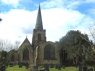
Duffield is a village in the Amber Valley district of Derbyshire, 5 miles (8.0 km) north of Derby. It is centred on the western bank of the River Derwent at the mouth of the River Ecclesbourne. It is within the Derwent Valley Mills World Heritage Area and the southern foothills of the Pennines.

<span class="mw-page-title-main">Bridges of York</span> Bridges over the Ouse and Foss in York, England

There are nine bridges across the River Ouse and eighteen smaller bridges and passages across the narrower River Foss within the city of York, England.

A postern is a secondary door or gate in a fortification such as a city wall or castle curtain wall. Posterns were often located in a concealed location which allowed the occupants to come and go inconspicuously. In the event of a siege, a postern could act as a sally port, allowing defenders to make a sortie on the besiegers. Placed in a less exposed, less visible location, they were usually relatively small, and therefore easily defensible.

<span class="mw-page-title-main">York city walls</span> Grade I listed urban defence in England

York has, since Roman times, been defended by walls of one form or another. To this day, substantial portions of the walls remain, and York has more miles of intact wall than any other city in England. They are known variously as York City Walls, the Bar Walls and the Roman walls. The walls are generally 13 feet (4m) high and 6 feet (1.8m) wide. They are the longest town walls in England.

<span class="mw-page-title-main">Siege of York</span> Siege of the English Civil War (1644)

The siege of York in 1644 was a prolonged contest for York during the First English Civil War, between the Scottish Covenanter army and the Parliamentarian armies of the Northern Association and Eastern Association, and the Royalist Army under the Marquess of Newcastle. It lasted from 22 April until 1 July when the city was relieved by Prince Rupert of the Rhine. Rupert and Newcastle were defeated the next day at the decisive Battle of Marston Moor, and the siege resumed until the city was surrendered on easy terms on 16 July.

<span class="mw-page-title-main">Strays of York</span> Public open spaces in York, England

The Strays of York is a collective name for four areas of open land, comprising in all over 800 acres (3.2 km2), within the City of York. Their individual names are Bootham Stray, Micklegate Stray, Monk Stray and Walmgate Stray.

York had around 45 parish churches in 1300. Twenty survive, in whole or in part, a number surpassed in England only by Norwich, and 12 are used for worship. This article consists of a list of medieval churches which still exist in whole or in part, and a list of medieval churches which are known to have existed in the past but have been completely demolished.

<span class="mw-page-title-main">Foss Islands branch line</span> Disused railway line in Yorkshire, England

The Foss Islands branch line was a former railway branch in the city of York. The line, about 1.75 miles (2.82 km) long, opened in 1880, connecting the York–Scarborough line of the North Eastern Railway to a large freight depot in the Foss Islands area of the city.

<span class="mw-page-title-main">York (Layerthorpe) railway station</span> Disused railway station in York, England

York (Layerthorpe) railway station was a railway station in the village of Layerthorpe in York, North Yorkshire, England.

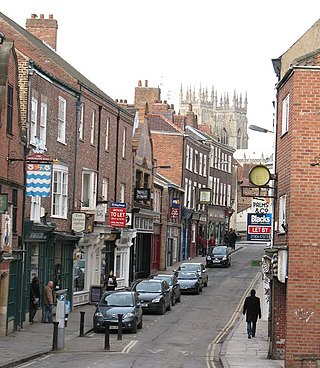
York and its district, the City of York, has many distinct localities, suburbs and villages.

Derwenthaugh Coke Works was a coking plant on the River Derwent near Swalwell in Gateshead. The works were built in 1928 on the site of the Crowley's Iron Works, which had at one time been the largest iron works in Europe. The coke works was closed and demolished in the late 1980s, and replaced by Derwenthaugh Park.

There were a number of engine sheds and railway works located in York. The large York North engine shed became the National Railway Museum in 1975.

<span class="mw-page-title-main">Piccadilly (York)</span> Street in York, England

Piccadilly is a street in the city centre of York, in England.

<span class="mw-page-title-main">Fossgate</span> Street in York, England

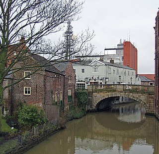
Fossgate is a street in the city centre of York, in England.

<span class="mw-page-title-main">Walmgate</span> Street in York, England

Walmgate is a street in the city centre of York, in England. During the Medieval period, the street was the site of a seafish and cattle market. Walmgate Bar was involved in the Siege of York in 1644, during the First English Civil War. During the 20th century, many of the older buildings were cleared away and newer structures put up.

<span class="mw-page-title-main">Lawrence Street (York)</span> Street in York, England

Lawrence Street is a road in York, in England, immediately south-east of the city centre.

<span class="mw-page-title-main">Peasholme Green</span> Street in York, England

Peasholme Green is a street on the eastern edge of the city centre of York, in England.

<span class="mw-page-title-main">Red Tower (York)</span> Medieval tower in York, England

The Red Tower is a medieval tower that formed part of the city defences of York, England. It is located on the city walls at Foss Islands Road, on the stretch of wall north of Walmgate Bar and is the only brick tower in the city.

References

  1. Historic England. "CHIMNEY AT WORKS AND SERVICES DEPOT OF YORK CITY COUNCIL, FOSS ISLANDS ROAD (Grade II) (1257848)". National Heritage List for England . Retrieved 16 August 2021.