
Pulau Legundi (also spelled Lagoendi) is an Indonesian island in the Sunda Strait between Java and Sumatra. It is one of the larger islands in the Strait and lies at the western end of Sumatra's Lampong Bay, in the province of Lampung.
Pulau Legundi (also spelled Lagoendi) is an Indonesian island in the Sunda Strait between Java and Sumatra. It is one of the larger islands in the Strait and lies at the western end of Sumatra's Lampong Bay, in the province of Lampung.
Although not so far from the mainland, Legundi is sparsely populated with about 80 inhabitants per square kilometer. Due to being lowly populated, agricultural cultivation has never been practiced on a large scale, which has kept intact the island's natural evergreen and semi-deciduous forests. [1] Tabuan Island is 40 kilometres (25 mi) to the west.
Due to the island's tropical nature and close proximity to the equator, seasons are not so distinct and temperatures are not so fluctuating. October tends to be both the wettest and warmest month at around 32°C, with the driest, coldest month being June at around 20°C.

Sumatra is one of the Sunda Islands of western Indonesia. It is the largest island that is entirely governed by Indonesia and the sixth-largest island in the world at 473,481 km2.

The Andaman Sea is a marginal sea of northeastern Indian Ocean bounded by the coastlines of Myanmar and Thailand along the Gulf of Martaban and west side of the Malay Peninsula, and separated from the Bay of Bengal to its west by the Andaman Islands and the Nicobar Islands. Its southernmost end is defined by Breueh Island, an island just north of Sumatra, and communicates with the Malacca Strait.

The Sunda Strait is the strait between the Indonesian islands of Java and Sumatra. It connects the Java Sea to the Indian Ocean. The name came from Sunda Kingdom, a kingdom ruling the west part of Java. It also comes from the name of the Sundanese people, the native people of West Java, with the Javanese people being found mostly in Central and East Java.

Lampung is a province of Indonesia. It is located on the southern tip of the island of Sumatra. It has a short border with the province of Bengkulu to the northwest, and a longer border with the province of South Sumatra to the north. It is the original home of the Lampung people, who speak their own language, and possess their own written script. Its capital is Bandar Lampung.

Thursday Island, colloquially known as TI, or in the indigenous language, Waiben, is an island of the Torres Strait Islands archipelago located approximately 39 kilometres north of Cape York Peninsula in the Torres Strait, Queensland, Australia. Thursday Island is also the name of the town in the south and west of the island and also the name of the locality which contains the island within the Shire of Torres. The town of Rose Hill is located on the north-eastern tip of the island.

Singapore is a very small, heavily urbanised, island city-state in Southeast Asia, located at the end of the Malayan Peninsula between Malaysia and Indonesia. Singapore has a total land area of 724.2 square kilometres (279.6 sq mi).
Kuraman Island, alternative name Keraman Island, is an outlying island in the Federal Territory of Labuan, Malaysia located on the northern mouth of Brunei Bay. It is sparsely populated and is popular with expatriates, divers and those who travel between Labuan and Brunei. Its land area measures 147 hectares. Together with the much smaller islands Pulau Rusukan Besar and Pulau Rusukan Kecil it forms the Labuan Marine Park.

Bagansiapiapi or simply known as Bagan is a city in Riau province on the island of Sumatra, Indonesia. The city is the capital of Rokan Hilir Regency in the Riau Province and is located on the east coast of Sumatra, on the Rokan River delta across the strait west of Malacca and near Dumai.

Penang Island, is the main constituent island of the Malaysian state of Penang. Located at the Malacca Strait, off the northwestern coast of Peninsular Malaysia, it is separated from the mainland by the Penang Strait. The island is home to nearly half of Penang's population; the city of George Town, which covers the island and the five outlying islets, is Malaysia's second largest city by population.

The silvery pigeon, also known as silvery wood-pigeon or grey wood-pigeon is a species of pigeon found in Indonesia and Malaysia. It was thought to be extinct but wild populations rediscovered in 2008 near Masokut Island might represent this species, and photographs from Simeulue confirm its existence there.

Gelugor is a southern suburb of George Town in Penang, Malaysia. Named after a plant species, Gelugor lies along the eastern seaboard of Penang Island, between Jelutong and Sungai Dua, and nearly 5 km (3.1 mi) south of the city centre.

The Banyak Islands are a group of inhabited islands located between Simeulue and Nias off the western coast of Sumatra in Indonesia's Aceh Province. Surveys of the area approximate around 71 islands and additional mangrove stands in shallow off-shore areas, although locals count 99 islands. The largest island in the group is Tuangku, with the principal town of Haloban. Two other major islands located either side of Tuangku are Bangkaru and Ujung Batu. Tuangku is separated from Bangkaru by a fault line.

Anyer, also known as Anjer or Angier, is a coastal town in Banten, formerly West Java, Indonesia, 82 miles (100 km) west of Jakarta and 15 kilometers (9 mi) south of Merak. A significant coastal town late 18th-century, Anyer faces the Sunda Strait.

Weh Island, often known as Sabang after the largest city, is a small active volcanic island to the northwest of Sumatra, 45 minutes by fast regular ship or 2 hours by ferry from mainland, Banda Aceh. It was originally connected to the Sumatran mainland and became separated by sea after the volcano's last eruption in the Pleistocene era. The island is situated in the Andaman Sea. The largest city on the island, Sabang, is the northernmost outpost of Indonesia.

Rupat is an island in the Strait of Malacca, and forms part of Bengkalis Regency within Riau Province of Indonesia. It lies just off the eastern coast of Sumatra, across from Dumai city, from which it is separated by the Rupat Strait. Its area is 1,490 km². With a population of 43,570 at the 2010 Census, the island is sparsely populated, with a population density of 29¼ per km². Rupat was one of thousands of abandoned islands, but now the population is growing year after year. It makes them expand the area for the settlement.
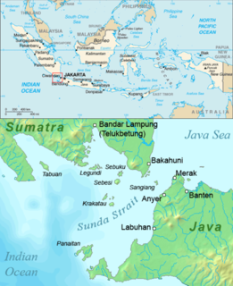
Panaitan is an island in the Sunda Strait, between Java and Sumatra, and in the Indonesian province of Banten. It is the largest island in the strait, and is located near the westernmost tip of Java. Like the nearby Krakatoa, it too is volcanic in origin, although there are no known historic eruptions. The name 'Prince's Island' apparently is because the island was considered the property of Javan princes. Administratively, the island is a part of Pandeglang Regency.

Sebuku is an island in the Sunda Strait between Java and Sumatra. It is one of the larger islands in the strait and lies just 2.5 kilometres (1.6 mi) to the north of Sebesi and 2.3 kilometres (1.4 mi) south of Sumatra. It is administratively part of South Lampung Regency, Lampung.

Tabuan Island is an island of southern Sumatra, under the jurisdiction of Lampung province.