Lira, Uganda

Last updated
Lira
Lira Uganda 2010 01 04.JPG
Uganda location map.svg
Red pog.svg
Lira
Location in Uganda
Coordinates: 02°14′50″N32°54′00″E / 2.24722°N 32.90000°E / 2.24722; 32.90000
Country Flag of Uganda.svg Uganda
Region Northern Region of Uganda
Sub-region Lango sub-region
District Lira District
Founded1919
Town Council1962
Municipality1985
City2020
Government
   Mayor Sam Atul [1]
Elevation
3,488 ft (1,063 m)
Population
 (2014 Census)
  Total99,059 [2]

Lira is a city in the Northern Region of Uganda. It is the main municipal, administrative, and commercial centre of Lira District. [3]

Contents

History

Lira was one of the last towns in Uganda held by loyalists of Idi Amin during the Uganda–Tanzania War (1978–1979). A force consisting of the Tanzania People's Defence Force's 201st Brigade and the Uganda National Liberation Front's Kikosi Maalum attacked Lira on 15 May 1979, ousting the Amin loyalists after a short battle. The clash at Lira was the last important battle of the Uganda–Tanzania War, as the remnants of Amin's army completely disintegrated thereafter. [4]

Location

Lira is approximately 100 kilometres (62 mi), by road, southeast of Gulu, the largest city in the Northern Region of Uganda, along the highway between Gulu and Mbale. [5] This is approximately 124 kilometres (77 mi) northwest of Soroti, the nearest city to the south. [6]

Lira City is located approximately 337 kilometres (209 mi), by road, north of the city of Kampala, the capital and largest city in the country. [7] The coordinates of Lira City are 2°14'50.0"N 32°54'00.0"E (Latitude:02.2472; Longitude:32.9000). [8] The city lies at an average elevation of 1,063 metres (3,488 ft), above sea level. [9]

Population

The 2002 national census estimated the population of Lira at 80,900. In 2010, the Uganda Bureau of Statistics (UBOS) estimated the population at 105,100. In 2011, UBOS estimated the mid-year population at 108,600. [10] The 2014 census put the population at 99,059. [2] The Night Population of Lira City Population is projected (Midyear 2020) from the 2014 National Population and Housing Census (NPHC) is 249,900. The day population is projected at 500,000.

A man selling jackfruit along the road in Lira, Uganda A man selling jackfruit along the road in Lira, Uganda.jpg
A man selling jackfruit along the road in Lira, Uganda

Transport

Lira is served by a railway station of the Uganda Railways network. [11] The city is also served by a public civilian airport, Lira Airport, administered by the Civil Aviation Authority of Uganda.

Power line

An 80 kilometres (50 mi) 132 kilovolt electricity line from the Karuma Power Station is under construction to a substation in Lira, under the supervision of Intec Gopa International Energy Consultants GmbH of Germany. [12]

Points of interest

The following additional points of interest lie within the town limits or close to the edges of the city:

Notable people

See also

Related Research Articles

<span class="mw-page-title-main">Soroti</span> Ugandan town

Soroti is a city in Eastern Region of Uganda. It is the main city, commercial, and administrative center in Soroti District, one of the nine administrative districts in the Teso sub-region. Soroti city was immediately approved for operationalization ahead of schedule by the Parliament of Uganda in the Financial Year 2020/2021.

<span class="mw-page-title-main">Tororo</span> Place in Eastern Region of Uganda, Uganda

Tororo is a town in the Eastern Region of Uganda. It is the main municipal, administrative, and commercial center of Tororo District.

<span class="mw-page-title-main">Moroto Town</span> Place in Northern Region, Uganda

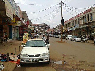
Moroto is a town in Moroto District in the Northern Region of Uganda. The town serves as the location of the district headquarters.

<span class="mw-page-title-main">Masaka</span> Place in Buganda Region, Uganda

Masaka is a district and a city in the Buganda Region in southern Uganda, west of Lake Victoria. The city is the headquarters of Masaka District.

<span class="mw-page-title-main">Apac</span> Ugandan town

Apac is a town in Apac District in the Northern Region of Uganda. It is the 'chief town' of the district and the district headquarters are located there. The district is named after the town.

Yumbe is a town in the Northern Region of Uganda. It is the district headquarters of Yumbe District.

Moyo, is the main municipal, administrative, and commercial center of Moyo District in the Northern Region of Uganda. The district headquarters are located here.

Aboke is a town in the Kole District of the Northern Region of Uganda. It was the location of the Aboke abductions in October 1996.

Nebbi is a town in the Nebbi District of the Northern Region of Uganda. It is the site of the district headquarters.

Lira Regional Referral Hospital, commonly known as Lira Hospital, is a hospital in Lira in the Northern Region of Uganda. It is the referral hospital for the districts of Amolatar, Apac, Dokolo, Lira, Kole, and Oyam.

<span class="mw-page-title-main">Mukono Town</span> Urban centre in Uganda

Mukono Town is a municipality in Mukono District in the Central Region of Uganda. The town is administered by the Mukono Town Council. The district headquarters are located in this town.

Wobulenzi is a municipality in Katikamu sub-county, in Luweero District in the Central Region of Uganda.

Amolatar is a town in Northern Uganda. It is the main municipal, administrative and commercial centre of Amolatar District. The district is named after the town.

Dokolo is a town in the Northern Region of Uganda. It is the main municipal, administrative, and commercial centre of Dokolo District.

Abim is a town in the Northern Region of Uganda. It is the chief municipal, administrative, and commercial center of Abim District. The district is named after the town.

Alebtong, is a town in the Northern Region of Uganda. It is the chief municipal, administrative, and commercial centre of Alebtong District. The district is named after the town.

Katunguru, is a settlement in Rubirizi District, Ankole sub-region, in the Western Region of Uganda. The name also applies to Katunguru Sub-county and Katunguru Parish, where the settlement is located.

The Soroti–Dokolo–Lira Road is a road in Uganda, connecting the towns of Soroti in Soroti District, Dokolo in Dokolo District, and Lira in Lira District.

Lira University (LU) is a university in Uganda. It is one of the eleven public universities and degree-awarding institutions in the country.

The Battle of Lira was one of the last battles in the Uganda–Tanzania War, fought between Tanzania and its Uganda National Liberation Front (UNLF) allies, and Uganda Army troops loyal to Idi Amin on 15 May 1979. The Tanzanian-led forces easily routed Lira's garrison of Amin loyalists, and then intercepted and destroyed one retreating column of Uganda Army soldiers near the town.

References

  1. Denis Ogwal (July 20, 2017). "Lira Municipal Development Forum Elects New Executive". New Vision. Retrieved June 9, 2018. ...among the development programs that the committee is mandated to monitor is the implementation of Uganda Support Municipal Infrastructural Development (USMID) program.
  2. 1 2 UBOS (27 August 2014). "The Population of The Regions of the Republic of Uganda And All Cities And Towns of More Than 15,000 Inhabitants". Citypopulation.de Quoting Uganda Bureau of Statistics (UBOS). Retrieved 21 February 2015.
  3. Draku, Franklin (22 May 2019). "Cabinet Elevates 15 Municipalities To Cities". Daily Monitor . Kampala. Retrieved 23 May 2019.
  4. Cooper & Fontanellaz 2015, pp. 37, 39.
  5. Google (19 January 2021). "Distance Between Gulu, Uganda And Lira, Uganda" (Map). Google Maps . Google. Retrieved 19 January 2021.
  6. Google (19 January 2021). "Distance Between Lira, Uganda And Soroti, Uganda" (Map). Google Maps . Google. Retrieved 19 January 2021.
  7. Google (19 January 2021). "Distance Between Kampala City Centre, Kampala, Uganda And Lira City Centre, Lira, Uganda" (Map). Google Maps . Google. Retrieved 19 January 2021.
  8. Google (19 January 2021). "Location of Lira City, Northern Region, Uganda" (Map). Google Maps . Google. Retrieved 19 January 2021.
  9. Floodmap (2018). "Elevation of Lira, Uganda". Floodmap.net. Retrieved 2 November 2019.
  10. UBOS. "Estimated Population of Lira In 2002, 2010 And 2011" (PDF). Uganda Bureau of Statistics (UBOS). Archived from the original (PDF) on 7 July 2014. Retrieved 3 June 2014.
  11. Cissy Makumbi, Cissy (28 October 2013). "Museveni Opens Gulu Railway Line". Daily Monitor . Retrieved 3 June 2014.
  12. Odyek, John (13 August 2015). "UETCL Signs €5.2 Million (USh20.5 Billion) Deal With German Company". New Vision . Kampala. Retrieved 13 August 2015.
  13. Schlein, Lisa (14 December 2014). "Ugandan Entrepreneur Creates Education Opportunity for Girls". Washington, DC: Voice of America . Retrieved 23 May 2019.
  14. Angoda Emmanuel. "School Report Cards System: What Works In Lira Town College & Northern Uganda". Lira, Uganda: AngodaEmma.Wordpress.com. Retrieved 23 May 2019.

Works cited

02°14′50″N32°54′00″E / 2.24722°N 32.90000°E / 2.24722; 32.90000