Related Research Articles
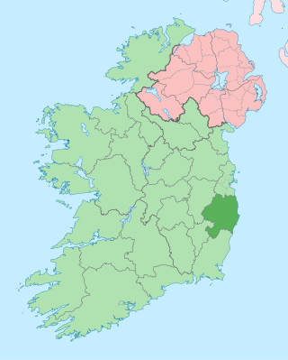
County Wicklow is a county in Ireland. The last of the traditional 32 counties, having been formed as late as 1606, it is part of the Eastern and Midland Region and the province of Leinster. It is bordered by the Irish Sea to the east and the counties of Wexford to the south, Carlow to the southwest, Kildare to the west, and South Dublin and Dún Laoghaire–Rathdown to the north.

County Donegal is a county of Ireland in the province of Ulster and in the Northern and Western Region. It is named after the town of Donegal in the south of the county. It has also been known as County Tyrconnell or Tirconaill, after the historic territory. Donegal County Council is the local council and Lifford is the county town.

County Cork is the largest and the southernmost county of Ireland, named after the city of Cork, the state's second-largest city. It is in the province of Munster and the Southern Region. Its largest market towns are Mallow, Macroom, Midleton, and Skibbereen. As of 2022, the county had a population of 584,156, making it the third-most populous county in Ireland. Cork County Council is the local authority for the county, while Cork City Council governs the city of Cork and its environs. Notable Corkonians include Michael Collins, Jack Lynch, Roy Keane, Sonia O'Sullivan, Cillian Murphy, and Graham Norton.

County Waterford is a county in Ireland. It is in the province of Munster and is part of the Southern Region. It is named after the city of Waterford. Waterford City and County Council is the local authority for the county. The population of the county at large, including the city, was 127,363 according to the 2022 census. The county is based on the historic Gaelic territory of the Déise. There is an Irish-speaking area, Gaeltacht na nDéise, in the southwest of the county.
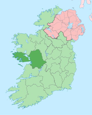
County Galway is a county in Ireland. It is in the Northern and Western Region, taking up the south of the province of Connacht. The county population was 276,451 at the 2022 census.
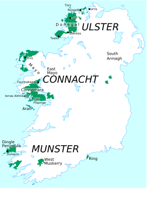
Gaeltacht are the districts of Ireland, individually or collectively, where the Irish government recognises that the Irish language is the predominant vernacular, or language of the home. The Gaeltacht districts were first officially recognised during the 1920s in the early years of the Irish Free State, following the Gaelic revival, as part of a government policy aimed at restoring the Irish language.

Ireland is an island in Northern Europe in the north Atlantic Ocean. The island lies on the European continental shelf, part of the Eurasian Plate. The island's main geographical features include low central plains surrounded by coastal mountains. The highest peak is Carrauntoohil, which is 1,039 metres (3,409 ft) above sea level. The western coastline is rugged, with many islands, peninsulas, headlands and bays. The island is bisected by the River Shannon, which at 360.5 km (224 mi) with a 102.1 km (63 mi) estuary is the longest river in Ireland and flows south from County Cavan in Ulster to meet the Atlantic just south of Limerick. There are a number of sizeable lakes along Ireland's rivers, of which Lough Neagh is the largest.

Central Canada is a Canadian region consisting of Ontario and Quebec, the largest and most populous provinces of the country. Geographically, they are not at the centre of Canada but instead overlap with Eastern Canada toward the east. Because of their large populations, Ontario and Quebec have traditionally held a significant amount of political power in Canada, leading to some amount of resentment from other regions of the country. Before Confederation, the term "Canada" specifically referred to Central Canada. Today, the term "Central Canada" is less often used than the names of the individual provinces.
Local government in Northern Ireland is divided among 11 districts. Councils in Northern Ireland do not carry out the same range of functions as those in the rest of the United Kingdom; for example they have no responsibility for education, road-building or housing. Their functions include planning, waste and recycling services, leisure and community services, building control and local economic and cultural development. The collection of rates is handled centrally by the Land and Property Services agency of the Northern Ireland Executive.
Ballincollig is a suburban town within the administrative area of Cork city in Ireland. It is located on the western side of Cork city, beside the River Lee on the R608 regional road. In 2016 it was the largest town in County Cork, at which time the Ballincollig Electoral Division had a population of 18,621 people. It is located beyond the green belt from the suburbs of Bishopstown and Wilton. Historically home to the Ballincollig Royal Gunpowder Mills which is now a Regional Park, the town has seen much growth in recent years as a satellite of Cork City. Ballincollig is within the Cork North-West Dáil constituency.
Airdrie is a city in Alberta, Canada, within the Calgary Region. It is located north of Calgary within the Calgary–Edmonton Corridor at the intersection of Queen Elizabeth II Highway and Highway 567.

Beaumont is a city in Leduc County within the Edmonton Metropolitan Region of Alberta, Canada. It is located at the intersection of Highway 625 and Highway 814, adjacent to the City of Edmonton and 6.0 kilometres (3.7 mi) northeast of the City of Leduc. The Nisku Industrial Park and the Edmonton International Airport are located 4.0 kilometres (2.5 mi) to the west and 8.0 kilometres (5.0 mi) to the southwest respectively.
An electoral division is a legally defined administrative area in the Republic of Ireland, generally comprising multiple townlands, and formerly a subdivision of urban and rural districts. Until 1996, EDs were known as district electoral divisions in the 29 county council areas and wards in the five county boroughs. Until 1972, DEDs also existed in Northern Ireland. The predecessor poor law electoral divisions were introduced throughout the island of Ireland in the 1830s. The divisions were used as local-government electoral areas until 1919 in what is now the Republic and until 1972 in Northern Ireland.

The South-West is a strategic planning area within the Southern Region in Ireland. It is a NUTS Level III statistical region of Ireland. It includes the city of Cork and the counties of Cork and Kerry. The South-West region spans 12,120 km2 (4,680 sq mi), roughly 16% of the total area of the state and according to the 2022 census has a population of 736,489.

Northern Ireland is divided into six counties, namely: Antrim, Armagh, Down, Fermanagh, Londonderry and Tyrone. Six largely rural administrative counties based on these were among the eight primary local government areas of Northern Ireland from its 1921 creation until 1973. The other two local government areas were the urban county boroughs of Derry and Belfast.

Cork is the second largest city in the Republic of Ireland, third largest on the island of Ireland, and largest in the province of Munster. At the 2022 census, it had a population of 222,526.
In Ireland, the term city has somewhat differing meanings in Northern Ireland and the Republic of Ireland.

The Mid-West is a strategic planning area within the Southern Region in Ireland. It is a NUTS Level III statistical region of Ireland. It consists of the counties of Clare and Tipperary, and the city and county of Limerick. Limerick City is the economic centre of the region. It spans 10,511 km2, 14.95% of the total area of the state and as of the 2022 census, it had a population of 505,369.
References
- ↑ "Report of the Expert Advisory Group on Local Government Arrangements in Cork". gov.ie. Department of Housing, Local Government and Heritage. Retrieved 28 October 2023.
Area (Cork County: 7,467.91 km2 / Cork City: 39.61 km2
- ↑ "County Profiles – Galway". Western Development Commission. Archived from the original on 2 June 2021. Retrieved 2 June 2021.
- ↑ "County Profiles – Mayo". Western Development Commission. Archived from the original on 2 June 2021. Retrieved 2 June 2021.
- ↑ "County Profiles – Donegal". Western Development Commission. Archived from the original on 2 June 2021. Retrieved 2 June 2021.
- ↑ County Kerry
- ↑ County Tipperary
- ↑ County Clare
- ↑ Northern Ireland General Register Office (1975). "Table 1: Area, Buildings for Habitation and Population, 1971". Census of Population 1971; Summary Tables (PDF). Belfast: HMSO. p. 1. Retrieved 28 August 2019.
- 1 2 3 4 "Areas, regions, and land divisions". Public Records Office of Northern Ireland. Archived from the original on 24 August 2015.
- ↑ County Limerick
- ↑ County Roscommon
- ↑ County Wexford
- ↑ County Meath
- ↑ County Kilkenny
- ↑ County Wicklow
- ↑ County Offaly
- ↑ County Cavan
- ↑ County Waterford
- ↑ County Westmeath
- ↑ County Sligo
- ↑ County Laois
- ↑ County Kildare
- ↑ County Fermanagh
- ↑ County Leitrim
- ↑ County Monaghan
- ↑ County Longford
- ↑ County Dublin
- ↑ County Carlow
- ↑ County Louth