Hernando de Soto's party was passing through a village at the confluence of the Mississippi River and Arkansas River on March 18. The ensuing flood only allowed passage by canoe and inundated fields surrounding the town.[2]
The largest flood ever recorded on the Missouri River and Upper Mississippi River in terms of discharge. This flood was particularly devastating since the region had few if any levees at the time. Among the hardest hit were the Wyandot who lost 100 people in the diseases that occurred after the flood. The flood also is the highest recorded for the Mississippi River at St. Louis. After the flood, Congress in 1849 passed the Swamp Act providing land grants to build stronger levees.[6]
The flood occurred after record-setting rainfalls across the U.S. Midwest and Plains from May to August, 1851. The State of Iowa experienced significant flooding extending to the Lower Mississippi River basin. Historical evidence suggest flooding occurred in the eastern Plains, from Nebraska to the Red River basin, but these areas were sparsely settled by white settlers in 1851. Heavy rainfall also occurred in the Ohio River basin. In June, major flooding on the Mississippi River was experienced.[4][5]
Heavy spring rains caused the Mississippi River to overflow, breaching levees and flooding enormous swathes of the Lower Mississippi Valley. The flooding began in February and only began to recede on May 20. According to the New Orleans Daily Picayune of May 3, thirty-one of Louisiana's fifty-three parishes (home to some 375,000 people) were entirely or partially underwater. The Picayune also reported that breaches at Hushpakana[sic.] and Bolivar, Mississippi, had "transformed the Yazoo Valley into an inland lake."[7] Mayor Louis A. Wiltz of New Orleans published a circular on May 30 addressed to "the Mayors of thirty-four large American cities" seeking contributions of cash and provisions for relief efforts. In the circular, the Flood of 1874 was described as the highest on record. It also included the observations of former U.S. Surveyor General for Louisiana William J. McCulloh, who estimated that a total of 12,565,060 acres had been flooded across Louisiana (8,065,000), Mississippi (2,500,000), and Arkansas (2,000,000).[8]
Flood of 1882
Intense spring rain storms beginning on February 19, 1882, led to a rapid rise of the Ohio River and flooding along the river from Cincinnati to St. Louis. The effects were much more devastating in the Lower Mississippi Valley, with an estimated 20,000 people made homeless in Arkansas alone. Such was the devastation that, in its wake, Southern Democrats and Midwestern Republicans in Congress hailing from those states afflicted by the flooding made common cause to increase appropriations for the Rivers and Harbor Act to $19 million, $5.4 million of which was earmarked for internal improvements and federal aid to the flooded areas. While not opposed to internal improvements on principle, President Chester A. Arthur nonetheless vetoed the Act on August 1, 1882. Congress overrode his veto the following day.[9]
Flood of 1891
Major flooding in the spring of 1891 on both the Ohio and Mississippi River, causing crevasses (bank and levee failures) in multiple locations of the lower Mississippi River valley, including Robertsonville, Mississippi; Concord, Louisiana; Carrollton (New Orleans), Louisiana; and Amesville (Marrero), Louisiana.[10] The most devastating of these levee failures was the one located on Ames Farm in Amesville, near present-day Barataria Blvd. Caused by a farmer that dug a "rice flume" to water crops, the breach started on March 16, 1891[11] and rapidly opened over the course of several days and weeks, expanding to approximately 1,000 feet in width accompanied by a river stage of 14.4 feet. At its peak, the crevasse was estimated to flow approximately 100,000 cubic feet per second.[10] The inundation of land stretched across several Louisiana Parishes, causing floodwater to flow directly towards neighboring Gretna and Plaquemines Parish, while upstream the backwater caused noticeable rises in streams as far as Thibodaux and Raceland on Bayou Lafourche. The flooding was catastrophic, causing losses to most planted crops in the region and disrupting freight and passenger rail service on the West Bank of the river for several months.
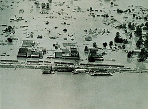
The 1927 flood was the greatest flood in modern history on the lower Mississippi River. In the summer of 1926 until the spring of 1927, heavy rains fell in eastern Kansas, Oklahoma, and the Ohio Valley. The White and Little Red rivers broke through the levees in Arkansas in February, flooding over 400km2 (99,000 acres) with 3 to 5m (9.8 to 16.4ft) of water.[12] The first levee break along the Mississippi River occurred a few miles south of Elaine, Arkansas, on March 29.[2]
Over the next six weeks, numerous levees broke along the Mississippi River from Illinois to Louisiana, which inundated numerous towns in the Mississippi Valley. The break at Mounds Landing near Greenville, Mississippi, was the single greatest crevasse to ever occur along the Mississippi River. It flooded an area 80km (50mi) wide and 160km (99mi) long with up to 6 metres (20ft) of water. Heavy spring rains caused a second major flood in the same region that June. In all, 73,500km2 (28,400sqmi) which were home to more than 931,000 people were inundated. To avoid flooding the city of New Orleans, the governor of Louisiana allowed engineers to create the Poydras cut, which saved the city but led to the flooding of St. Bernard and Plaquemines parishes instead. Millions of acres across seven states were flooded. Evacuees totaled 500,000. Economic losses were estimated at US$1 billion (1927 dollars), which was equivalent to almost one-third of the federal budget at that time. [13]
The Ohio River flood of $500 million. The Birds Point-New Madrid Floodway was operated for the first time to reduce river stages along the Lower Ohio River and the reach of the Mississippi River adjacent to the floodway. The Bonnet Carre Spillway was opened for the first time and had 285 of the 350 bays opened for 48 days. New Orleans crested at 19.29 feet (5.88m) on Feb 28th.[5]
Flood of 1945
Flooding between March and May resulted in Baton Rouge reaching its second highest recorded crest at 45.18 feet (13.77m) on April 29. The Bonnet Carre Spillway was opened for the second time for 57 days.[5]
Flood of 1965
The spring 1965 flood on the Upper Mississippi is still the flood of record for from about 100 miles north of Minneapolis, Minnesota, to Hannibal, Missouri.[14] The crests of that April exceeded previous records by several feet at many river gauge sites. Those record crests still exceed the second highest crest by a foot or more at many of those same sites. This flood caused $225 million in damage to public and private properties, with $173 million of that occurring along the main stem of the Mississippi River mid April through early May.[15]
The Mississippi Flood of 1973 occurred between March and May 1973 on the lower Mississippi River.[5] The flood resulted in the largest volume of water to flow down the Mississippi since the Great Mississippi Flood of 1927. Both the Bonnet Carre Spillway and the Morganza Spillway were employed. The Bonnet Carre was fully opened between April 7 and June 14 for a record 75 days. The 1973 flood was the first time the Morganza Spillway was opened: from April 19 through June 13.
Flood of 1975
In April, 225 bays of the Bonnet Carre Spillway were opened for 15 days, the shortest duration on record. Reserve, Louisiana, had a crest of 24 feet (7.3m) on April 14. the 8th highest on record.[5]
Flood of 1979
April, all 350 bays of the Bonnet Carre Spillway were opened for 45 days. Red River Landing crested at 59.19 feet (18.04m) on April 23.[5]
Lower Mississippi Flood of 1983
The flood between May and June was the second most severe flood in the lower Mississippi Basin since 1927. Red River Landing, Louisiana, reached the 4th highest crest of record at 60.52 feet (18.45m) on June 5 and was flooded for 115 days. All bays of the Bonnet Carre Spillway were opened for 35 days.[5]
Great Flood of 1993, with the Mississippi River out of its banks in Festus, Missouri.
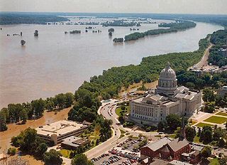
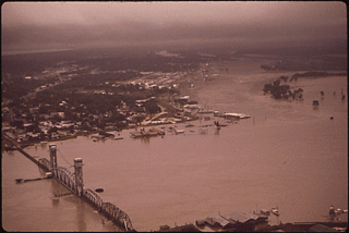
Great Mississippi and Missouri Rivers Flood of 1993
The flood occurred on the Mississippi and Missouri rivers and their tributaries between April and October 1993. The flooded area totaled around 30,000 square miles (80,000km2)[16] and was the worst since the Great Mississippi Flood of 1927 as measured by duration, square miles inundated, persons displaced, crop and property damage and number of record river levels.
Flood of 2002
In April, Red River Landing reached 58.60ft (17.86m), the 8th highest crest on record.[5][17]
Between April 11 and May 12, heavy rain in the Mississippi River Valley necessitated the opening of the Bonnet Carre Spillway for the first time in 11 years. 160 bays were opened for 31 days. Red River Landing crested at 60.68 feet (18.50m) on April 24, the 3rd highest on record .[5]
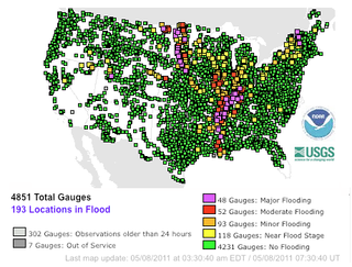
The Mississippi River floods in April and May 2011 were among the largest and most damaging along the U.S. waterway in the past century, rivalling major floods in 1927 and 1993. In April 2011, two major storm systems dumped record rainfall on the Mississippi River watershed. Rising from springtime snowmelt, the river and many of its tributaries began to swell to record levels by the beginning of May. Areas along the Mississippi itself experiencing flooding include Illinois, Iowa, Missouri, Kentucky, Tennessee, Arkansas, Mississippi, and Louisiana. U.S. President Barack Obama declared the western counties of Kentucky, Tennessee, and Mississippi federal disaster areas.[18] The Birds Point-New Madrid Floodway was operated for a second time to reduce river stages along the Lower Ohio River and the reach of the Mississippi River adjacent to the floodway. For the second time in 38 years, the Morganza Spillway has been opened, deliberately flooding 4,600 square miles (12,000km2) of rural Louisiana to save most of Baton Rouge and New Orleans.[19]
Flood of 2014
The Upper Mississippi River flooded in the summer of 2014 as the result of record rainfall in Minnesota, Iowa, Wisconsin and Illinois.[20]
2017 flooding
The middle portion of the Mississippi approached historical record flooding. The National Weather Service anticipated a 48.5ft. crest at Cape Girardeau, Missouri on May 5, 2017, which was within 6 inches of the January 2, 2016, crest of 48.86ft.[21]
The Great flood of the Missouri and Mississippi Rivers 2019
The Mississippi river floods to levels similar to the 1993 Great Mississippi and Missouri Floods in Davenport, Iowa. 4 people have been reported dead as of May 3, 2019.[22]
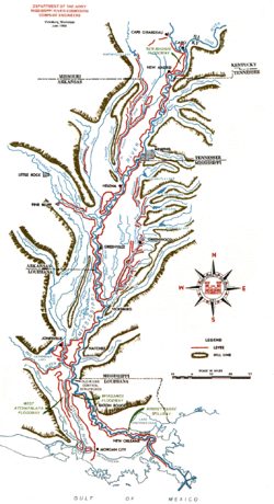
The Mississippi River is the primary river, and second-longest river, of the largest drainage basin in the United States. From its traditional source of Lake Itasca in northern Minnesota, it flows generally south for 2,340 miles (3,766 km) to the Mississippi River Delta in the Gulf of Mexico. With its many tributaries, the Mississippi's watershed drains all or parts of 32 U.S. states and two Canadian provinces between the Rocky and Appalachian mountains. The main stem is entirely within the United States; the total drainage basin is 1,151,000 sq mi (2,980,000 km2), of which only about one percent is in Canada. The Mississippi ranks as the thirteenth-largest river by discharge in the world. The river either borders or passes through the states of Minnesota, Wisconsin, Iowa, Illinois, Missouri, Kentucky, Tennessee, Arkansas, Mississippi, and Louisiana.
Montz is a census-designated place (CDP) in St. Charles Parish, Louisiana, United States. It first appeared in the 2000 census with a population of 1,120. The 2020 census indicates a population of 2,106.
St. Charles Parish is a parish located in the U.S. state of Louisiana. At the 2020 census, its population was 52,549. The parish seat is Hahnville and the most populous community is Luling.
The Great Mississippi Flood of 1927 was the most destructive river flood in the history of the United States, with 27,000 square miles (70,000 km2) inundated in depths of up to 30 feet (9 m) over the course of several months in early 1927. The period cost of the damage has been estimated to be between $246 million and $1 billion, which ranges from $4.2–$17.3 billion in 2023 dollars.
The Jefferson Highway was an automobile highway stretching through the central United States from New Orleans, Louisiana, to Winnipeg, Manitoba in Canada. The Jefferson Highway was replaced with the new numbered US Highway system in the late 1920s. Portions of the highway are still named Jefferson Highway, for example: the portions that run through Jefferson Parish, Louisiana; East Baton Rouge Parish, Louisiana; Lee's Summit, Missouri; Osseo, Minnesota; and Wadena, Minnesota.
The Great Flood of 1993 was a flood that occurred in the Midwestern United States, along the Mississippi and Missouri rivers and their tributaries, from April to October 1993.
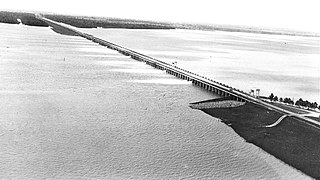
Bird's Point is an unincorporated community in Mississippi County, Missouri, United States. It lies on an island or former island in the Mississippi River, near the confluence of the Ohio and Mississippi Rivers and is situated directly across from Cairo, Illinois. This is the point where the U.S. Route 60 bridge connects with Cairo.
Drainage in New Orleans, Louisiana, has been a major concern since the founding of the city in the early 18th century, remaining an important factor in the history of New Orleans today. The central portion of metropolitan New Orleans is fairly unusual in that it is almost completely surrounded by water: Lake Pontchartrain to the north, Lake Borgne to the east, wetlands to the east and west, and the Mississippi River to the south. Half of the land area between these bodies of water is at or below sea level, and no longer has a natural outlet for flowing surface water. As such, virtually all rainfall occurring within this area must be removed through either evapotranspiration or pumping. Thus, flood threats to metropolitan New Orleans include the Mississippi River, Lake Pontchartrain, canals throughout the city, and natural rainfall. Artificial levees have been built to keep out rising river and lake waters but have had the negative effect of keeping rainfall in, and have failed on numerous occasions.
The Bonnet Carré Spillway is a flood control operation in the Lower Mississippi Valley. Located in St. Charles Parish, Louisiana, about 12 miles (19 km) west of New Orleans, it allows floodwaters from the Mississippi River to flow into Lake Pontchartrain and thence into the Gulf of Mexico. The spillway was constructed between 1929 and 1931, following the Great Mississippi Flood of 1927, and has been designated as a National Historic Civil Engineering Landmark by the American Society of Civil Engineers.
The Atchafalaya Basin, or Atchafalaya Swamp, is the largest wetland and swamp in the United States. Located in south central Louisiana, it is a combination of wetlands and river delta area where the Atchafalaya River and the Gulf of Mexico converge. The river stretches from near Simmesport in the north through parts of eight parishes to the Morgan City southern area.
Bonnet Carré may refer to:
The Bonnet Carré Crevasse (1871) was one of several levee breaches in the Bonnet Carré area in the mid-to-late 19th century. Bonnet Carré was approximately 31 miles (50 km) from New Orleans, Louisiana.
The Morganza Spillway or Morganza Control Structure is a flood-control structure in the U.S. state of Louisiana. It is located along the western bank of the Lower Mississippi River at river mile 280, near Morganza in Pointe Coupee Parish. The spillway stands between the Mississippi and the Morganza Floodway, which leads to the Atchafalaya Basin and the Atchafalaya River in south-central Louisiana. Its purpose is to divert water from the Mississippi River during major flood events by flooding the Atchafalaya Basin, including the Atchafalaya River and the Atchafalaya Swamp. The spillway and adjacent levees also help prevent the Mississippi from changing its present course through the major port cities of Baton Rouge and New Orleans to a new course down the Atchafalaya River to the Gulf of Mexico. The Morganza Spillway, operated by the U.S. Army Corps of Engineers, was opened during the 1973 and 2011 Mississippi River floods.
Caernarvon is an unincorporated community in St. Bernard Parish, Louisiana, United States. The name of the community is from a plantation originally located here. The plantation's name is widely believed to be from a similarly named town and castle in Wales. Names of antebellum plantations in the American South were often reflective of European roots and aspirations of grandeur; two upriver Mississippi River plantations, Nottoway near White Castle, Louisiana, and Sans Souci near Osceola, Arkansas, are two examples of this tradition.
Major floods along the Mississippi River in April and May 2011 were among the largest and most damaging recorded along the U.S. waterway in the past century, comparable in extent to the Great Mississippi Flood of 1927 and Great Flood of 1993. In April 2011, two large storm systems deposited record levels of rainfall on the Mississippi River drainage basin. When that additional water combined with the springtime snowmelt, the river and many of its tributaries began to swell to record levels by the beginning of May. Flooding occurred in Illinois, Missouri, Kentucky, Tennessee, Arkansas, Mississippi, and Louisiana.
The Birds Point-New Madrid Floodway is a flood control component of the Mississippi River and Tributaries Project located on the west bank of the Mississippi River in southeast Missouri just below the confluence of the Ohio and Mississippi Rivers. The construction of the floodway was authorized by the Flood Control Act of 1928 and later modified by the Flood Control Act of 1965. Its purpose is to divert water from the Mississippi River during major flood events and lower the flood stages upstream, notably at Cairo, Illinois.
The project design flood is a hypothetical "maximum probable" flood of the Mississippi River used by the United States Army Corps of Engineers to aid in the design and execution of flood protection in the Mississippi Valley.
The Mississippi flood of 1973 occurred between March and May 1973 on the lower Mississippi River. The flooding was the third most severe along the U.S.'s Mississippi River during the 20th century.
The West Atchafalaya Floodway is a flood control structure of the Mississippi River and Tributaries Project located in the Lower Atchafalaya Basin in south-central Louisiana. It has a project design flood flow capacity of 250,000 cu ft/s (7,100 m3/s).
Flooding in the Mississippi River Basin during the winter, spring, and summer of 2019 caused at least 12 deaths and economic losses in 19 states totaling in excess of $20 billion. Estimated damages in the Midwestern United States alone had reached $12.5 billion by April 2019. Flood damages totaling $6.2 billion were reported in the 11 states bordering the Mississippi River. In addition to property and crop losses and infrastructure damages, commercial navigation on the Mississippi River was interrupted repeatedly by high currents, low bridge clearances, and closed locks. This delayed shipments of agricultural commodities, adding to the economic stress of crop losses caused by flooding. As of late April 2019, shipments of corn to export terminals in Louisiana were 31% lower than in same period in 2018.
This page is based on this Wikipedia article Text is available under the CC BY-SA 4.0 license; additional terms may apply. Images, videos and audio are available under their respective licenses.