Related Research Articles

Orangeburg County is a county located in the U.S. state of South Carolina. As of the 2020 census, the population was 84,223. Its county seat is Orangeburg. The county was created in 1769.

Georgetown County is a county located in the U.S. state of South Carolina. As of the 2020 census, the population was 63,404. Its county seat is Georgetown. The county was founded in 1769. It is named for George III of the United Kingdom.

The Waccamaw River is a river, approximately 140 miles (225 km) long, in southeastern North Carolina and eastern South Carolina in the United States. It drains an area of approximately 1,110 square miles (2886 km²) in the coastal plain along the eastern border between the two states into the Atlantic Ocean. Along its upper course, it is a slow-moving, blackwater river surrounded by vast wetlands, passable only by shallow-draft watercraft such as canoe. Along its lower course, it is lined by sandy banks and old plantation houses, providing an important navigation channel with a unique geography, flowing roughly parallel to the coast.

The Francis Marion National Forest is located north of Charleston, South Carolina. It is named for revolutionary war hero Francis Marion, who was known to the British as the Swamp Fox. It lies entirely within the Middle Atlantic coastal forests ecoregion. The park is also entirely in the Subtropical coniferous forest.
The Fort Mill Ridge Wildlife Management Area is located on 217 acres (0.88 km2) two miles (3 km) southwest of Romney in Hampshire County, West Virginia. Fort Mill Ridge WMA is owned by the West Virginia Division of Natural Resources. The Fort Mill Ridge Civil War Trenches are located at the top of the Fort Mill Ridge access road.
The Pee Dee Area Council is a Boy Scouts organization located in northeastern South Carolina.

Waccamaw National Wildlife Refuge, established in 1997, is a recent addition to the United States National Wildlife Refuge system. It is located in parts of northeastern Georgetown County, South Carolina, southern Horry, and southeastern Marion counties, and contains lands adjacent to the Pee Dee River, the Little Pee Dee River, and the Waccamaw River near their confluence. Currently the size of the refuge is 22,931 acres (92.80 km2) but plans call for the total refuge to be over 50,000 acres (200 km2).

The High Hills of Santee, sometimes known as the High Hills of the Santee, is a long, narrow hilly region in the western part of Sumter County, South Carolina. It has been called "one of the state's most famous areas". The High Hills of Santee region lies north of the Santee River and east of the Wateree River, one of the two rivers that join to form the Santee. It extends north almost to the Kershaw county line and northeasterly to include the former summer resort town of Bradford Springs. Since 1902 the town has been included in Lee County.

Situated along the Pee Dee River, Pee Dee National Wildlife Refuge contains 8,443 acres (34.17 km2) in Anson and Richmond Counties, North Carolina. The refuge was established to provide wintering habitat for migratory waterfowl. The refuge was established in October 1963 to provide habitat for geese and other waterfowl.

The Yadkin–Pee Dee River Basin is a large river basin in the eastern United States, covering around 7,221 square miles, making it the second largest in the state of North Carolina. Its headwaters rise near Blowing Rock, North Carolina, and the basin drains to the Atlantic Ocean in Winyah Bay, east of Georgetown, South Carolina.

The Southeastern mixed forests are an ecoregion of the temperate broadleaf and mixed forest biome, in the lower portion of the Eastern United States.

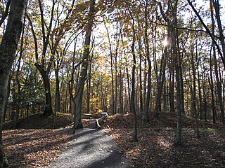
Poinsett State Park is located in Sumter County in the U.S. state of South Carolina. The park is best known for its botanical oddities, combining the flora of the Blue Ridge Mountains foothills and Piedmont of Upstate South Carolina, the xeric Sandhills and the Atlantic coastal plain. In Poinsett State Park one can see mountain laurels draped with Spanish moss. The park, which has been called "weird and beautiful", is named after amateur botanist and South Carolina native Joel Roberts Poinsett, the first American ambassador to Mexico and popularizer of the poinsettia. There is a $3 charge for admission to Poinsett State Park and there are small fees for overnight camping and cabin rentals. The park is surrounded by the Manchester State Forest, and both provide access to the Palmetto Trail, linked hiking and mountain bike trails, and Manchester State Forest offers equestrian trails.

Botany Bay Plantation Wildlife Management Area is a state preserve on Edisto Island, South Carolina. Botany Bay Plantation was formed in the 1930s from the merger of the Colonial-era Sea Cloud Plantation and Bleak Hall Plantation. In 1977, it was bequeathed to the state as a wildlife preserve; it was opened to the public in 2008. The preserve includes a number of registered historic sites, including two listed in the National Register of Historic Places: a set of three surviving 1840s outbuildings from Bleak Hall Plantation, and the prehistoric Fig Island shell rings.

Big Woods Wildlife Management Area is a 4,173-acre (16.89 km2) Wildlife Management Area (WMA) in Sussex County, Virginia. It comprises two tracts of land; the 2,208-acre (8.94 km2) main tract, located immediately adjacent Big Woods State Forest, and the 1,965-acre (7.95 km2) Parker's Branch tract, located nearby.
West Bay Wildlife Management Area, also known as West Bay WMA, is a 59,189-acre tract of protected area near Elizabeth in Allen Parish, Louisiana. The WMA is managed by the Louisiana Department of Wildlife and Fisheries (LDWF) from land owned by Boise Paper Solutions, Roy O. Martin Lumber Company, Forest Investments Associates, and Weyerhaeuser.
Peason Ridge Wildlife Management Area, also referred to as Peason Ridge WMA, is a 74,309-acre tract of protected area located in the Parishes of Natchitoches, Sabine, and Vernon, in the state of Louisiana. The WMA is managed by the Louisiana Department of Wildlife and Fisheries (LDWF).
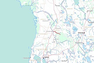
The Little Withlacoochee River is a 16-mile long river with its headwaters starting in the Richloam Wildlife Management Area in Sumter County, Florida. The Little Withlacoochee River ends near River Junction Campground just east of Silver Lake in the Croom Wildlife Management Area. It makes up a portion of the Hernando-Sumter County border. Its drainage basin covers 145 mi² (376 km²) of Hernando County and Sumter County.

The protected areas of North Carolina cover roughly 3.8 million acres, making up 11% of the total land in the state. 86.5% of this protected land is publicly owned and is managed by different federal and state level authorities and receive varying levels of protection. Some areas are managed as wilderness while others are operated with acceptable commercial exploitation. The remainder of the land is privately owned, but willingly entered into conservation easement management agreements, or are owned by various nonprofit conservation groups such as the National Audubon Society and The Nature Conservancy. North Carolina contains 1 National Park, and various other federally owned protected land including 2 National Seashores, 5 National Forests, 12 Wildlife Refuges, and the southern half of the Blue Ridge Parkway. North Carolina has an extensive state park system of 42 open units, 35 of which are state parks, 4 that are recreation areas, and 3 staffed state natural areas, along with other designated units managed by the North Carolina Department of Natural and Cultural Resources.
References
- ↑ "South Carolina Department of Natural Resources". www2.dnr.sc.gov. Retrieved 2023-01-17.