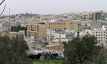
Ramallah is a Palestinian city in the central West Bank or Ramallah Bank, that serves as the de facto administrative capital of the State of Palestine. It is situated on the Judaean Mountains, 10 km north of Jerusalem, at an average elevation of 872 meters (2,861 ft) above sea level, adjacent to al-Bireh.

The Palestinian territories are the two regions of the former British Mandate for Palestine that have been occupied by Israel since the Six-Day War of 1967, namely the West Bank and the Gaza Strip. The International Court of Justice (ICJ) has referred to the West Bank, including East Jerusalem, as "the Occupied Palestinian Territory", and this term was used as the legal definition by the ICJ in its advisory opinion of July 2004. The term occupied Palestinian territory was used by the United Nations and other international organizations between October 1999 and December 2012 to refer to areas controlled by the Palestinian National Authority, but from 2012, when Palestine was admitted as one of its non-member observer states, the United Nations started using exclusively the name State of Palestine. The European Union (EU) also uses the term "occupied Palestinian territory". The government of Israel and its supporters use the label "disputed territories" instead.

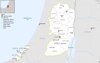
Palestine, officially the State of Palestine, is a country in the southern Levant region of West Asia. It encompasses two disconnected territories — the West Bank and the Gaza Strip, collectively known as the Palestinian territories — within the larger region of Palestine. The country shares its borders with Israel to north, west and south, Jordan to the east and Egypt to the southwest. It has a combined land area of 6,020 square kilometres (2,320 sq mi) while its population exceeds five million people. Its proclaimed capital is Jerusalem while Ramallah serves as its administrative center and Rafah is currently its largest city. Arabic is the official language. The majority of Palestinians practice Islam while Christianity also has a significant presence.

Beit Jala is a Palestinian Christian town in the Bethlehem Governorate of Palestine, in the West Bank. Beit Jala is located 10 km (6.2 mi)10 km south of Jerusalem, on the western side of the Hebron road, opposite Bethlehem, at 825 meters (2,707 ft) altitude. In 2017, Beit Jala had 13,484 inhabitants according to the Palestinian Central Bureau of Statistics. About 80% of the population were Christians and about 20% Muslims.
Beit Hanoun or Beit Hanun is a Palestinian city on the northeast edge of the Gaza Strip. According to the Palestinian Central Bureau of Statistics, the town had a population of 52,237 in 2017. From mid-2007 until late 2023, it was administered by the Hamas administration. Beit Hanoun has been entirely depopulated, and virtually all its structures have either been destroyed or rendered unusable due to extreme damage following the Israel-Hamas war. The remains of Beit Hanoun are located by the Nahal-Hanun stream, 6 kilometers (3.7 mi) away from the Israeli town of Sderot.

Municipal elections were held between December 2004 and December 2005, to elect members of local councils in the Palestinian Territories. The elections were approved by President Yasser Arafat of the Palestinian National Authority (PNA), before his death on 11 November 2004. They were administered by the Higher Committee for Local Elections (HCLE), a body established under the authority of the Ministry for Local Government, an institution of the Palestinian National Authority.

Demographic features of the population of the area commonly described as Palestinian territories includes information on ethnicity, education level, health of the populace, economic status, religious affiliations and other aspects of that population.
The Coordinator of Government Activities in the Territories is a unit in the Israeli Ministry of Defense that engages in coordinating civilian issues between the Government of Israel, the Israel Defense Forces, international organizations, diplomats, and the Palestinian Authority. It is the main organ remaining of the mostly defunct Israeli Civil Administration, which had governed the West Bank and the Gaza Strip between 1981 and 1994.

Highway 60 or is a south–north intercity road in Israel and the Palestinian West Bank that stretches from Beersheba to Nazareth.

The Ramallah and al-Bireh Governorate is one of 16 governorates of Palestine. It covers a large part of the central West Bank, on the northern border of the Jerusalem Governorate. Its district capital or muhfaza (seat) is the city of al-Bireh.

Beit Ummar is a Palestinian town located eleven kilometers northwest of Hebron in the Hebron Governorate of the State of Palestine. According to the Palestinian Central Bureau of Statistics, in 2017, the town had a population of 16,977 inhabitants. Over 4,800 residents of the town are under the age of 18. Since the Second Intifada, unemployment ranges between 60 and 80 percent due mostly to the inability of residents to work in Israel and a depression in the Palestinian economy. A part of the city straddles Road 60 and due to this, several propositions of house demolition have occurred.
Bani Zeid is a Palestinian town in the Ramallah and al-Bireh Governorate of Palestine, in the north-central West Bank, located 27 kilometers (17 mi) northwest of Ramallah, about 45 kilometers northwest of Jerusalem and about 6 kilometers (3.7 mi) southwest of Salfit. A town of over 6,000 inhabitants, Bani Zeid was founded when the villages of Deir Ghassaneh and Beit Rima merged to form a municipality in 1966 during the Jordanian rule.
Qatanna is a Palestinian town in the central West Bank part of the Jerusalem Governorate, located 12 km. northwest of Jerusalem. According to the Palestinian Central Bureau of Statistics, the town had a population of 6,981 inhabitants in 2017. Primary health care for the town is level 2.

Beit Sira is a Palestinian village in the central West Bank, located 22 kilometers west of Ramallah and is a part of the Ramallah and al-Bireh Governorate. The village is situated along the Green Line. During the 1948 Arab-Israeli War, around 4,000 dunams of its land became a part of the "No-Man's Land" strip between the north-central West Bank and Israel. Currently Beit Sira's jurisdiction is 3,120 dunams, of which 441 dunams are built-up areas and the remainder is open spaces for future construction or agricultural land.

Tourism in the Palestinian territories is tourism in East Jerusalem, the West Bank, and the Gaza Strip. In 2010, 4.6 million people visited the Palestinian territories, compared to 2.6 million in 2009. Of that number, 2.2 million were foreign tourists while 2.7 million were domestic. In the last quarter of 2012 over 150,000 guests stayed in West Bank hotels; 40% were European and 9% were from the United States and Canada. Major travel guides write that "the West Bank is not the easiest place in which to travel but the effort is richly rewarded."
The 2011–2012 Palestinian protests were a series of protests in the Palestinian National Authority and the Hamas-ruled Gaza Strip, staged by various Palestinian groups as part of the wider Arab Spring. The protests were aimed to protest against the Palestinian government, as well as supporting the popular uprisings in Tunisia, Egypt and Syria. The first phase of protests took place during 2011 and the second phase in 2012.
At-Tira is a Palestinian village in the Ramallah and al-Bireh Governorate in the northern West Bank.