List of countries that border only one other country

Last updated

This is a list of countries that have a land border with only one other country. Some on this list have a maritime border with additional countries. Some countries, which are not listed here, have no land border but do have a maritime border with a single other country, such as Sri Lanka.

Contents

There are generally three arrangements by which a country would have a single land border:

Territory leased or ceded by one country to another for perpetual use, but not in sovereignty, such as Guantanamo Bay Naval Base in Cuba, or memorials, such as the American Cemetery in France, do not constitute true territorial borders because the land occupied remains a formal part of the host country.

This list is based on the Correlates of War Direct Contiguity data set, with maritime causeways and bridges not being counted. [1]

Countries bordering only one other country

Landlocked

CountryNeighbourBorder lengthNotes
kmmi
Flag of Lesotho.svg  Lesotho Flag of South Africa.svg  South Africa 909565Lesotho is an enclave which is entirely surrounded by South Africa.
Flag of San Marino.svg  San Marino Flag of Italy.svg  Italy 3924San Marino is an enclave entirely surrounded by Italy.
Flag of the Vatican City (2023-present).svg  Vatican City 3.22.0The Vatican City is an enclave entirely surrounded by Rome, Italy.

With coast

CountryNeighbourBorder lengthNotes
kmmi
Flag of Brunei.svg  Brunei Flag of Malaysia.svg  Malaysia 381237Borders the Malaysian state of Sarawak on the island of Borneo.
Flag of the Dominican Republic.svg  Dominican Republic Flag of Haiti.svg  Haiti 360220On the island of Hispaniola
Flag of The Gambia.svg  The Gambia Flag of Senegal.svg  Senegal 740460The Republic of the Gambia is bordered to the north, south and east by Senegal.
Flag of Haiti.svg  Haiti Flag of the Dominican Republic.svg  Dominican Republic 360220On the island of Hispaniola
Flag of Ireland.svg  Republic of Ireland Flag of the United Kingdom.svg  United Kingdom 360220The Republic of Ireland borders the United Kingdom's Northern Ireland region on the island of Ireland.
Flag of Monaco.svg  Monaco Flag of France.svg  France 4.42.7
Flag of Papua New Guinea.svg  Papua New Guinea Flag of Indonesia.svg  Indonesia 820510On the island of New Guinea
Flag of Portugal.svg  Portugal Flag of Spain.svg  Spain 1,214754
Flag of Qatar.svg  Qatar Flag of Saudi Arabia.svg  Saudi Arabia 6037The planned Qatar–Bahrain Causeway would connect Qatar to Bahrain.
Flag of South Korea.svg  South Korea Flag of North Korea.svg  North Korea 238148On the Korean Peninsula, at the Demarcation Line. The two countries are separated by a 4 km wide Demilitarized Zone. Both Koreas claim the Korean Peninsula.
Flag of East Timor.svg  Timor-Leste Flag of Indonesia.svg  Indonesia 228142On the island of Timor.
Flag of the United Kingdom.svg  United Kingdom Flag of Ireland.svg  Republic of Ireland 360220On the island of Ireland. The British Overseas Territories of Gibraltar and Akrotiri and Dhekelia border Spain and Cyprus respectively, but these territories are not part of the United Kingdom proper (see #Dependent territories section).

Causeways, bridges, and tunnels

Passport Island, the site of the land border between Bahrain and Saudi Arabia, is seen at the far left. Each nation has a border checkpoint on the island on opposite sides of the border. Manama bahrain.jpg
Passport Island, the site of the land border between Bahrain and Saudi Arabia, is seen at the far left. Each nation has a border checkpoint on the island on opposite sides of the border.

Often called fixed crossings or fixed links, transportation corridors constructed to cross bodies of water without any intermittent connections such as ferries or ships may be between different states. These may be considered artificial "persistent" borderpoints for land vehicles or pedestrians, but are not typically considered land borders given their need for continuous operation and maintenance, as well as their ease of volume control or closure by either state. Two countries are islands and have no land borders, but maintain fixed borderpoints with other nations.

CountryLand neighbourBorderpoint neighbourNotes
Flag of the United Kingdom.svg  United Kingdom Flag of Ireland.svg  Republic of Ireland Flag of France.svg  France In addition to its border with Ireland, has a fixed link with France in the Channel Tunnel.
Flag of Bahrain.svg  Bahrain None, Since Bahrain is an island.Flag of Saudi Arabia.svg  Saudi Arabia Although an island nation with no natural land borders, Bahrain maintains persistent connection to Saudi Arabia by the King Fahd Causeway at Passport Island.
Flag of Singapore.svg  Singapore None, Since Singapore is cut off by a strait. (Specifically, the Strait of Johor.)Flag of Malaysia.svg  Malaysia Although an island nation with no natural land borders, Singapore maintains persistent connections to Malaysia by the Johor Causeway and the Malaysia–Singapore Second Link.
Flag of Liechtenstein.svg  Liechtenstein Flag of Austria.svg  Austria Flag of Switzerland (Pantone).svg   Switzerland In addition to its land border with Austria, Liechtenstein has five bridges crossing the river Rhine to Switzerland.

Dependent territories

In some cases, a dependent territory of one nation borders another nation.

TerritorySovereigntyNeighbourBorder lengthNotes
km
Flag of the United Kingdom.svg  Akrotiri and Dhekelia Flag of the United Kingdom.svg  United Kingdom Flag of Cyprus.svg  Cyprus 108British sovereign base areas, border the Republic of Cyprus. Dhekelia also borders the Turkish Republic of Northern Cyprus, but the latter is recognised only by Turkey.
Flag of Gibraltar.svg  Gibraltar Flag of the United Kingdom.svg  United Kingdom Flag of Spain.svg  Spain 1.2A British overseas territory, occupies a small peninsula and has a 1.2 km (0.75 mi) land border with Spain. Spain claims some of Gibraltar as its own territory.
Flag of New Zealand.svg  Ross Dependency Flag of New Zealand.svg  New Zealand Flag of Australia (converted).svg  Australia New Zealand's (largely unrecognised) territorial claim in Antarctica borders only the Australian Antarctic Territory and the unclaimed Marie Byrd Land. (It also touches other claims at the South Pole.)

Integral parts of sovereign states

In most cases, an integral part of a larger country shares a border with another nation.

TerritorySovereigntyNeighbourBorder lengthNotes
Flag of Aland.svg  Åland Flag of Finland.svg  Finland Flag of Sweden.svg  Sweden 528,60 mAutonomous region of Finland. Åland had a dispute in Market Island.
Flag of the French Southern and Antarctic Lands.svg  French Southern and Antarctic Lands Flag of France.svg  France Flag of Australia (converted).svg  Australia 5.533.470,05 m Adélie Land, France's (largely unrecognised) claim in Antarctica borders only the Australian Antarctic Territory. (It also touches other claims at the South Pole.)
Flag of Greenland.svg  Greenland Flag of Denmark (state).svg  Kingdom of Denmark Flag of Canada (Pantone).svg  Canada 1,280 mA constituent country of the Kingdom of Denmark, Greenland had a border dispute with Canada regarding uninhabited Hans Island. The island is located in the centre of the Kennedy Channel of Nares Strait (between Canada's Ellesmere Island and northern Greenland), which constitutes the agreed maritime border. On June 11, 2022, both countries signed an agreement to split the island, which will come into effect as soon as the parliaments of Canada, Denmark, Greenland, and Nunavut ratify it. [2]
Flag of France.svg  Saint Martin Flag of France.svg  France Flag of the Netherlands.svg  Kingdom of the Netherlands 16The island is split between two island territories: the northern half, Saint-Martin, is a French overseas collectivity; the southern half, Sint Maarten, is a constituent country of the Kingdom of the Netherlands.
Flag of Sint Maarten.svg  Sint Maarten Flag of the Netherlands.svg  Kingdom of the Netherlands Flag of France.svg  France

Historical

Many countries historically had only one neighbour. Some no longer exist while others now have either no land borders or borders with more than one nation due to border changes.

See also

Related Research Articles

<span class="mw-page-title-main">Colony</span> Territory governed by another country

A colony is a territory subject to a form of foreign rule. Though dominated by the foreign colonizers, the rule remains separate to the original country of the colonizers, the metropolitan state, which together have often been organized as colonial empires, particularly with the development of modern imperialism and its colonialism. This coloniality and possibly colonial administrative separation, while often blurred, makes colonies neither annexed or integrated territories nor client states. Colonies contemporarily are identified and organized as not sufficiently self-governed dependent territories. Other past colonies have become either sufficiently incorporated and self-governed, or independent, with some to a varying degree dominated by remaining colonial settler societies or neocolonialism.

<span class="mw-page-title-main">Provinces and territories of Canada</span> Top-level subdivisions of Canada

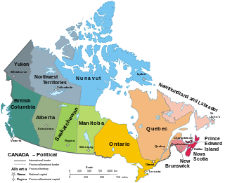
Canada has ten provinces and three territories that are sub-national administrative divisions under the jurisdiction of the Canadian Constitution. In the 1867 Canadian Confederation, three provinces of British North America—New Brunswick, Nova Scotia, and the Province of Canada —united to form a federation, becoming a fully independent country over the next century. Over its history, Canada's international borders have changed several times as it has added territories and provinces, making it the world's second-largest country by area.

<span class="mw-page-title-main">Bophuthatswana</span> Former bantustan in South Africa (1977–94)

Bophuthatswana, officially the Republic of Bophuthatswana, was a Bantustan that was declared (nominally) independent by the apartheid regime of South Africa in 1977. However, like the other Bantustans of Ciskei, Transkei and Venda, its independence was not recognized by any country other than South Africa.

<span class="mw-page-title-main">Bantustan</span> Territory created by the Apartheid regime of South Africa

A Bantustan was a territory that the National Party administration of South Africa set aside for black inhabitants of South Africa and South West Africa, as a part of its policy of apartheid.

<span class="mw-page-title-main">British North America</span> Former British imperial territories

British North America comprised the colonial territories of the British Empire in North America from 1783 onwards. English colonisation of North America began in the 16th century in Newfoundland, then further south at Roanoke and Jamestown, Virginia, and more substantially with the founding of the Thirteen Colonies along the Atlantic coast of North America.

Mainland is defined as "relating to or forming the main part of a country or continent, not including the islands around it [regardless of status under territorial jurisdiction by an entity]." The term is often politically, economically and/or demographically more significant than politically associated remote territories, such as exclaves or oceanic islands situated outside the continental shelf.

<span class="mw-page-title-main">Exclusive economic zone</span> Adjacent sea zone in which a state has special rights

An exclusive economic zone (EEZ), as prescribed by the 1982 United Nations Convention on the Law of the Sea, is an area of the sea in which a sovereign state has exclusive rights regarding the exploration and use of marine resources, including energy production from water and wind.

<span class="mw-page-title-main">Colonial empire</span> Overseas possessions of a nation-state

A colonial empire is a collective of territories, either contiguous with the imperial center or located overseas, settled by the population of a certain state and governed by that state.

<span class="mw-page-title-main">Enclave and exclave</span> Territory (or part of one) entirely surrounded by the territory of one other state

An enclave is a territory that is entirely surrounded by the territory of only one other state or entity. Such territory can be a small territory as part of a larger one. Enclaves may also exist within territorial waters. Enclave is sometimes used improperly to denote a territory that is only partly surrounded by another state. Many enclaves are also exclaves, but some are not, for example Vatican City and San Marino and Lesotho are completely enclaved sovereign states.

<span class="mw-page-title-main">Vhembe District Municipality</span> District municipality in Limpopo, South Africa

The Vhembe District Municipality is one of the 5 districts of the Limpopo province of South Africa. It is the northernmost district of the country and shares its northern border with the Beitbridge District in Zimbabwe and on the east with the Gaza Province in Mozambique. Vhembe consists of all the territories that were part of the former Venda Bantustan; however, two large densely populated districts of the former Tsonga homeland of Gazankulu, in particular, Hlanganani and Malamulele, were also incorporated into the municipality, hence the ethnic diversity of the district. The seat is Thohoyandou, the capital of the former Venda Bantustan. According to the 2011 census, the majority of the municipality's 800,000 inhabitants spoke TshiVenda as their mother language, while 400,000 spoke Xitsonga as their home language. However, the Tsonga people form the majority south of the Levubu River, while the Venda are the minority south of Levubu at 15%. The Sepedi speakers number 27,000. The district code is DC34.

<span class="mw-page-title-main">Geography of the African Union</span>

The African Union covers almost the entirety of continental Africa and several off-shore islands. Consequently, it is wildly diverse, including the world's largest hot desert, huge jungles and savannas, and the world's longest river.

<span class="mw-page-title-main">Former colonies and territories in Canada</span>

A number of states and polities formerly claimed colonies and territories in Canada prior to the evolution of the current provinces and territories under the federal system. North America prior to colonization was occupied by a variety of indigenous groups consisting of band societies typical of the sparsely populated North, to loose confederacies made up of numerous hunting bands from a variety of ethnic groups, to more structured confederacies of sedentary farming villages, to stratified hereditary structures centred on a fishing economy. The colonization of Canada by Europeans began in the 10th century, when Norsemen explored and, ultimately unsuccessfully, attempted to settle areas of the northeastern fringes of North America. Early permanent European settlements in what is now Canada included the late 16th and 17th century French colonies of Acadia and Canada, the English colonies of Newfoundland (island) and Rupert's Land, the Scottish colonies of Nova Scotia and Port Royal.

<span class="mw-page-title-main">Exclusive economic zone of North Korea</span> North Korean maritime boundary

The exclusive economic zone of North Korea stretches 200 nautical miles from its basepoints in both the Yellow Sea and the Sea of Japan. The exclusive economic zone (EEZ) was declared in 1977 after North Korea had contested the validity of the Northern Limit Lines (NLL) set up after the Korean War as maritime borders. The EEZ has not been codified in law and North Korea has never specified its coordinates, making it difficult to determine its specific scope.

<span class="mw-page-title-main">Palestinian enclaves</span> Fragmentation of the West Bank over time

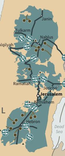
The Palestinian enclaves are areas in the West Bank designated for Palestinians under a variety of unsuccessful U.S. and Israeli-led proposals to end the Israeli–Palestinian conflict. The enclaves are often compared to the nominally self-governing black homelands created in apartheid-era South Africa, and are thus referred to as bantustans. They have been referred to figuratively as the Palestinian archipelago, among other terms. The de facto status in 2024 is that Israel controls all area outside these enclaves.

References

  1. "Direct Contiguity Data, 1816-2016. Version 3.2". Correlates of War Project. Retrieved 12 December 2017.
  2. Austen, Ian (2022-06-14). "Canada and Denmark End Their Arctic Whisky War" . The New York Times . Retrieved 2022-09-13.